Hickman County, Tennessee
| Hickman County, Tennessee | |
|---|---|
 Hickman County Courthouse in Centerville | |
|
Location in the U.S. state of Tennessee | |
 Tennessee's location in the U.S. | |
| Founded | 1807 |
| Named for | Edwin Hickman, explorer[1] |
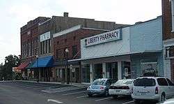
| Seat | Centerville |
| Largest town | Centerville |
| Area | |
| • Total | 613 sq mi (1,588 km2) |
| • Land | 612 sq mi (1,585 km2) |
| • Water | 0.1 sq mi (0 km2), 0.02% |
| Population | |
| • (2010) | 24,690 |
| • Density | 40/sq mi (20/km2) |
| Congressional district | 7th |
| Time zone | Central: UTC−6/−5 |
| Website |
hickmanco |
Hickman County is a county located in the U.S. state of Tennessee. As of the 2010 census, the population was 24,690.[2] Its county seat is Centerville.[3]
Hickman County is part of the Nashville–Davidson–Murfreesboro–Franklin, TN Metropolitan Statistical Area.
History
Hickman County was named for Edwin Hickman, an explorer and surveyor who was killed in an Indian attack at Defeated Creek[4] in 1791.
The county was established in 1807, and named for Hickman at the suggestion of Robert Weakley, a legislator who had been a member of Hickman's surveying party.[1] The original county was vast, extending to the southern border of the state. Hickman County was reduced in extent when it partially contributed to the formations of four counties: Wayne and Lawrence Counties in 1817, Perry County in 1819, and Lewis County in 1843.
Hickman and the Duck River valley was originally claimed by the Chickasaw people of western Tennessee and northern Mississippi. Among its first white settlers was John Gordon, the famous "Captain of the Spies" who later fought at Horseshoe Bend and at Pensacola under Andrew Jackson.
Gordon acquired land in Chickasaw territory in what is now Hickman County on the banks of the Duck River, where, in a partnership with Chief William "Chooshemataha" Colbert, he operated a ferry and Indian trading post for settlers traveling on the Natchez Trace.[5]
The trace was a war-path later made into a federal road for settlers moving from Tennessee to the lower Mississippi territory. The Chickasaw ceded the land to Tennessee in 1805 and Gordon kept the estate, moving his family there in 1812 and eventually amassing a plantation of over 1500 acres. The Gordon House still stands by the Duck River today, now maintained by the Natchez Trace National Parkway. Throughout the 19th century, the county's industry revolved around iron furnaces, which made use of the county's natural supply of high-quality iron ore.[1]
Early furnaces included Napier's furnace near Aetna, which was destroyed by Union soldiers during the Civil War, and furnaces built by the Standard Coal Company in the 1880s.[1]
Hickman natives include songwriter Beth Slater Whitson and Grand Ole Opry personality Minnie Pearl.[1] William F. Lyell was a corporal in the United States Army during the Korean War. He was posthumously awarded the Medal of Honor for his actions on August 31, 1951.
The county is the subject of the Johnny Cash song "Saturday Night In Hickman County", and the Hickman community of Grinder's Switch is indirectly mentioned in the song, "The South's Gonna Do It Again", by the Charlie Daniels Band (one line refers to the band Grinderswitch, and their song "Right On Time").
Geography
According to the U.S. Census Bureau, the county has a total area of 613 square miles (1,590 km2), of which 612 square miles (1,590 km2) is land and 0.1 square miles (0.26 km2) (0.02%) is water.[6] The Duck River, the Piney River, and many creeks, large and small, run through Hickman County.
Adjacent counties
- Dickson County (north)
- Williamson County (east)
- Maury County (southeast)
- Lewis County (south)
- Perry County (west)
- Humphreys County (northwest)
National protected area
- Natchez Trace Parkway (part)
State protected areas
- Beaver Dam Creek Wildlife Management Area
- MTSU Wildlife Management Area
- John Noel State Natural Area
Demographics
| Historical population | |||
|---|---|---|---|
| Census | Pop. | %± | |
| 1810 | 2,583 | — | |
| 1820 | 6,080 | 135.4% | |
| 1830 | 8,119 | 33.5% | |
| 1840 | 8,618 | 6.1% | |
| 1850 | 9,397 | 9.0% | |
| 1860 | 9,312 | −0.9% | |
| 1870 | 9,856 | 5.8% | |
| 1880 | 12,095 | 22.7% | |
| 1890 | 14,499 | 19.9% | |
| 1900 | 16,367 | 12.9% | |
| 1910 | 16,527 | 1.0% | |
| 1920 | 16,216 | −1.9% | |
| 1930 | 13,613 | −16.1% | |
| 1940 | 14,873 | 9.3% | |
| 1950 | 13,353 | −10.2% | |
| 1960 | 11,862 | −11.2% | |
| 1970 | 12,096 | 2.0% | |
| 1980 | 15,151 | 25.3% | |
| 1990 | 16,754 | 10.6% | |
| 2000 | 22,295 | 33.1% | |
| 2010 | 24,690 | 10.7% | |
| Est. 2016 | 24,295 | [7] | −1.6% |
| U.S. Decennial Census[8] 1790–1960[9] 1900–1990[10] 1990–2000[11] 2010–2014[2] | |||
As of the census[13] of 2000, there were 22,295 people, 8,081 households, and 5,955 families residing in the county. The population density was 36 people per square mile (14/km²). There were 8,904 housing units at an average density of 14 per square mile (6/km²). The racial makeup of the county was 93.71% White, 4.53% Black or African American, 0.48% Native American, 0.08% Asian, 0.01% Pacific Islander, 0.29% from other races, and 0.90% from two or more races. 1.00% of the population were Hispanic or Latino of any race.
There were 8,081 households out of which 33.90% had children under the age of 18 living with them, 59.40% were married couples living together, 9.60% had a female householder with no husband present, and 26.30% were non-families. 22.60% of all households were made up of individuals and 9.90% had someone living alone who was 65 years of age or older. The average household size was 2.59 and the average family size was 3.02.
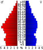
In the county, the population was spread out with 24.70% under the age of 18, 8.50% from 18 to 24, 31.00% from 25 to 44, 23.80% from 45 to 64, and 12.00% who were 65 years of age or older. The median age was 36 years. For every 100 females, there were 112.50 males. For every 100 females age 18 and over, there were 111.50 males.
The median income for a household in the county was $31,013, and the median income for a family was $36,342. Males had a median income of $29,411 versus $21,185 for females. The per capita income for the county was $14,446. About 11.60% of families and 14.30% of the population were below the poverty line, including 15.90% of those under age 18 and 18.40% of those age 65 or over.
Communities
Town
Census-designated places
Unincorporated communities
Politics
| Year | Republican | Democratic | Third Parties |
|---|---|---|---|
| 2016 | 72.9% 5,695 | 23.4% 1,824 | 3.8% 294 |
| 2012 | 62.6% 4,758 | 35.5% 2,698 | 1.9% 146 |
| 2008 | 56.3% 4,784 | 41.9% 3,563 | 1.8% 151 |
| 2004 | 50.3% 4,359 | 49.2% 4,263 | 0.6% 51 |
| 2000 | 40.1% 2,914 | 58.4% 4,239 | 1.5% 111 |
| 1996 | 31.2% 2,002 | 61.0% 3,917 | 7.8% 499 |
| 1992 | 27.1% 1,820 | 60.8% 4,093 | 12.1% 814 |
| 1988 | 45.7% 2,246 | 53.7% 2,643 | 0.6% 29 |
| 1984 | 44.4% 2,370 | 55.1% 2,941 | 0.4% 23 |
| 1980 | 36.4% 1,903 | 61.7% 3,225 | 2.0% 102 |
| 1976 | 24.1% 1,154 | 75.0% 3,590 | 0.9% 43 |
| 1972 | 56.1% 1,943 | 40.2% 1,393 | 3.8% 130 |
| 1968 | 17.3% 760 | 26.3% 1,152 | 56.4% 2,473 |
| 1964 | 26.2% 1,019 | 73.8% 2,877 | |
| 1960 | 33.2% 1,224 | 65.1% 2,401 | 1.7% 62 |
| 1956 | 29.8% 1,040 | 69.8% 2,439 | 0.5% 17 |
| 1952 | 28.4% 1,044 | 71.4% 2,625 | 0.3% 10 |
| 1948 | 16.6% 478 | 74.4% 2,140 | 9.0% 260 |
| 1944 | 21.7% 618 | 78.1% 2,223 | 0.2% 5 |
| 1940 | 18.8% 644 | 80.8% 2,776 | 0.4% 14 |
| 1936 | 16.3% 353 | 83.3% 1,804 | 0.4% 8 |
| 1932 | 17.5% 385 | 82.2% 1,812 | 0.4% 8 |
| 1928 | 33.0% 510 | 67.1% 1,038 | |
| 1924 | 25.0% 315 | 73.3% 922 | 1.7% 21 |
| 1920 | 51.6% 1,470 | 47.8% 1,362 | 0.5% 15 |
| 1916 | 40.6% 1,026 | 58.5% 1,479 | 1.0% 25 |
| 1912 | 38.1% 868 | 56.5% 1,288 | 5.4% 124 |
See also
References
- 1 2 3 4 5 Edward Dotson, "Hickman County," Tennessee Encyclopedia of History and Culture. Retrieved: 17 October 2013.
- 1 2 "State & County QuickFacts". United States Census Bureau. Archived from the original on July 11, 2011. Retrieved December 2, 2013.
- ↑ "Find a County". National Association of Counties. Archived from the original on 2011-05-31. Retrieved 2011-06-07.
- ↑ Summerlin, Cathy (February 1, 1999). Traveling Tennessee: A Complete Tour Guide to the Volunteer State from the Highlands of the Smoky Mountains to the Banks of the Mississippi River. Thomas Nelson Inc. p. 285. ISBN 978-1-4185-5968-7.
- ↑ "The Gordon House: A Home on the Natchez Trace" (PDF). National Park Service. Retrieved 2016-12-13.
- ↑ "2010 Census Gazetteer Files". United States Census Bureau. August 22, 2012. Retrieved April 5, 2015.
- ↑ "Population and Housing Unit Estimates". Retrieved June 9, 2017.
- ↑ "U.S. Decennial Census". United States Census Bureau. Archived from the original on May 12, 2015. Retrieved April 5, 2015.
- ↑ "Historical Census Browser". University of Virginia Library. Retrieved April 5, 2015.
- ↑ Forstall, Richard L., ed. (March 27, 1995). "Population of Counties by Decennial Census: 1900 to 1990". United States Census Bureau. Retrieved April 5, 2015.
- ↑ "Census 2000 PHC-T-4. Ranking Tables for Counties: 1990 and 2000" (PDF). United States Census Bureau. April 2, 2001. Retrieved April 5, 2015.
- ↑ Based on 2000 census data
- ↑ "American FactFinder". United States Census Bureau. Retrieved 2011-05-14.
- ↑ Leip, David. "Dave Leip's Atlas of U.S. Presidential Elections". uselectionatlas.org. Retrieved 2018-03-10.
External links
| Wikimedia Commons has media related to Hickman County, Tennessee. |
- Official site
- Hickman County, TNGenWeb – free genealogy resources for the county
- Hickman County at Curlie (based on DMOZ)
Places adjacent to Hickman County, Tennessee | ||||||||||
|---|---|---|---|---|---|---|---|---|---|---|
| ||||||||||
Municipalities and communities of Hickman County, Tennessee, United States | ||
|---|---|---|
| Town | ||
| CDPs | ||
| Unincorporated communities | ||
| Principal City | ||
|---|---|---|
| Other Major Cities | ||
| Counties | ||
