Lannédern
| Lannédern Lannedern | |
|---|---|
| Commune | |
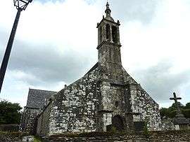 The church of Saint-Edern, in Lannédern | |
 Lannédern Location within Brittany region  Lannédern | |
| Coordinates: 48°18′05″N 3°53′46″W / 48.3014°N 3.8961°WCoordinates: 48°18′05″N 3°53′46″W / 48.3014°N 3.8961°W | |
| Country | France |
| Region | Brittany |
| Department | Finistère |
| Arrondissement | Châteaulin |
| Canton | Briec |
| Intercommunality | Région de Pleyben |
| Government | |
| • Mayor (2014–2020) | Georges Pouliquen |
| Area1 | 12.43 km2 (4.80 sq mi) |
| Population (2008)2 | 301 |
| • Density | 24/km2 (63/sq mi) |
| Time zone | UTC+1 (CET) |
| • Summer (DST) | UTC+2 (CEST) |
| INSEE/Postal code | 29115 /29190 |
| Elevation | 80–201 m (262–659 ft) |
|
1 French Land Register data, which excludes lakes, ponds, glaciers > 1 km2 (0.386 sq mi or 247 acres) and river estuaries. 2 Population without double counting: residents of multiple communes (e.g., students and military personnel) only counted once. | |
Lannédern (Breton: Lannedern) is a commune in the Finistère department of Brittany in north-western France.
Population
| Historical population | ||
|---|---|---|
| Year | Pop. | ±% |
| 1793 | 527 | — |
| 1800 | 621 | +17.8% |
| 1806 | 482 | −22.4% |
| 1821 | 606 | +25.7% |
| 1831 | 631 | +4.1% |
| 1836 | 623 | −1.3% |
| 1841 | 577 | −7.4% |
| 1846 | 663 | +14.9% |
| 1851 | 666 | +0.5% |
| 1856 | 669 | +0.5% |
| 1861 | 671 | +0.3% |
| 1866 | 616 | −8.2% |
| 1872 | 634 | +2.9% |
| 1876 | 678 | +6.9% |
| 1881 | 720 | +6.2% |
| 1886 | 766 | +6.4% |
| 1891 | 751 | −2.0% |
| 1896 | 758 | +0.9% |
| 1901 | 863 | +13.9% |
| 1906 | 831 | −3.7% |
| 1911 | 818 | −1.6% |
| 1921 | 775 | −5.3% |
| 1926 | 766 | −1.2% |
| 1931 | 713 | −6.9% |
| 1936 | 667 | −6.5% |
| 1946 | 612 | −8.2% |
| 1954 | 566 | −7.5% |
| 1962 | 531 | −6.2% |
| 1968 | 477 | −10.2% |
| 1975 | 409 | −14.3% |
| 1982 | 361 | −11.7% |
| 1990 | 309 | −14.4% |
| 1999 | 272 | −12.0% |
| 2008 | 301 | +10.7% |
See also
References
- Mayors of Finistère Association (in French);
External links
- French Ministry of Culture list for Lannédern (in French)
| Wikimedia Commons has media related to Lannédern. |
This article is issued from
Wikipedia.
The text is licensed under Creative Commons - Attribution - Sharealike.
Additional terms may apply for the media files.