Lange Glacier
| Lange Glacier | |
|---|---|
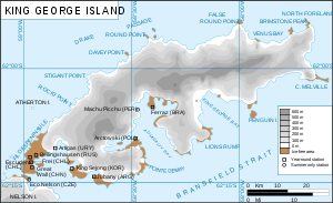 Map of King George Island | |
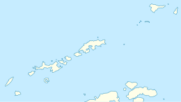
 Lange Glacier (Antarctica) Show map of Antarctica | |
| Location |
King George Island South Shetland Islands |
| Coordinates | 62°07′00″S 58°30′00″W / 62.11667°S 58.50000°W / -62.11667; -58.50000 |
| Thickness | unknown |
| Terminus | Admiralty Bay |
| Status | unknown |
Lange Glacier (62°7′S 58°30′W / 62.117°S 58.500°W / -62.117; -58.500Coordinates: 62°7′S 58°30′W / 62.117°S 58.500°W / -62.117; -58.500) is a glacier flowing into the west side of Admiralty Bay close south of Admiralen Peak, King George Island, in the South Shetland Islands, Antarctica. It was charted by the French Antarctic Expedition, 1908–10, under Jean-Baptiste Charcot, and was named by the UK Antarctic Place-Names Committee in 1960 for Alexander Lange (1860–1922), a Norwegian pioneer of modern steam whaling in the South Shetland Islands in 1905–6, and commander of the Admiralen.[1]
See also
References
- ↑ "Lange Glacier". Geographic Names Information System. United States Geological Survey. Retrieved 2013-05-29.

| Types | |||||||
|---|---|---|---|---|---|---|---|
| Anatomy | |||||||
| Processes | |||||||
| Measurements | |||||||
| Volcanic relations | |||||||
| Landforms |
| ||||||
| |||||||
This article is issued from
Wikipedia.
The text is licensed under Creative Commons - Attribution - Sharealike.
Additional terms may apply for the media files.