Usher Glacier
| Usher Glacier | |
|---|---|
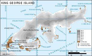 Map of King George Island | |
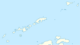
 Usher Glacier (Antarctica) Show map of Antarctica | |
| Location |
King George Island South Shetland Islands |
| Coordinates | 62°02′00″S 58°37′00″W / 62.03333°S 58.61667°W / -62.03333; -58.61667 |
| Length | 4 nmi (7 km; 5 mi) |
| Thickness | unknown |
| Terminus | north west of Stigant Point |
| Status | unknown |
Usher Glacier (62°2′S 58°37′W / 62.033°S 58.617°W / -62.033; -58.617Coordinates: 62°2′S 58°37′W / 62.033°S 58.617°W / -62.033; -58.617) is a glacier nearly 4 nautical miles (7 km) long, flowing northwest into the sea between Stigant Point and Davey Point on the north coast of King George Island, in the South Shetland Islands. Named by the United Kingdom Antarctic Place-Names Committee (UK-APC) in 1960 for J. Usher, Master of the Caraquet from Liverpool, who visited the South Shetland Islands in 1821-22.
See also
References

| Types | |||||||
|---|---|---|---|---|---|---|---|
| Anatomy | |||||||
| Processes | |||||||
| Measurements | |||||||
| Volcanic relations | |||||||
| Landforms |
| ||||||
| |||||||
This article is issued from
Wikipedia.
The text is licensed under Creative Commons - Attribution - Sharealike.
Additional terms may apply for the media files.