Ritya Glacier
| Ritya Glacier | |
|---|---|
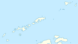
 Location of Smith Island in the South Shetland Islands | |
 Location of Ritya Glacier in Antarctica  Ritya Glacier (Antarctica) | |
| Location |
Smith Island South Shetland Islands |
| Coordinates | 62°55′15″S 62°22′30″W / 62.92083°S 62.37500°W |
| Length | 1 nautical mile (1.9 km; 1.2 mi) |
| Width | 0.8 nautical miles (1.5 km; 0.92 mi) |
| Thickness | unknown |
| Terminus | Linevo Cove |
| Status | unknown |
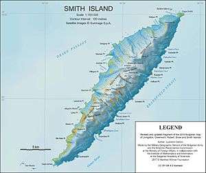
Topographic map of Smith Island.
Ritya Glacier (Bulgarian: ледник Ритя, ‘Lednik Ritya’ \'led-nik 'ri-tya\) is the steep 1.8 km long and 1.4 km wide glacier draining the southeast slopes of Imeon Range on Smith Island in the South Shetland Islands, Antarctica. It is situated northeast of Nosei Glacier, southeast of Kongur Glacier and south of Saparevo Glacier, flows southeastwards from Mount Christi and enters the head of Linevo Cove on Boyd Strait.
The glacier is named after the settlement of Ritya in Northern Bulgaria.
Location
Ritya Glacier is centred at 62°55′15″S 62°22′30″W / 62.92083°S 62.37500°WCoordinates: 62°55′15″S 62°22′30″W / 62.92083°S 62.37500°W. Bulgarian mapping in 2009 and 2010.
See also
Maps
- Chart of South Shetland including Coronation Island, &c. from the exploration of the sloop Dove in the years 1821 and 1822 by George Powell Commander of the same. Scale ca. 1:200000. London: Laurie, 1822.
- L.L. Ivanov. Antarctica: Livingston Island and Greenwich, Robert, Snow and Smith Islands. Scale 1:120000 topographic map. Troyan: Manfred Wörner Foundation, 2010. ISBN 978-954-92032-9-5 (First edition 2009. ISBN 978-954-92032-6-4)
- South Shetland Islands: Smith and Low Islands. Scale 1:150000 topographic map No. 13677. British Antarctic Survey, 2009.
- Antarctic Digital Database (ADD). Scale 1:250000 topographic map of Antarctica. Scientific Committee on Antarctic Research (SCAR). Since 1993, regularly upgraded and updated.
- L.L. Ivanov. Antarctica: Livingston Island and Smith Island. Scale 1:100000 topographic map. Manfred Wörner Foundation, 2017. ISBN 978-619-90008-3-0
References
- This article includes information from the Antarctic Place-names Commission of Bulgaria which is used with permission.
External links
- Bulgarian Antarctic Gazetteer. Antarctic Place-names Commission. (details in Bulgarian, basic data in English)
- Ritya Glacier SCAR Composite Antarctic Gazetteer

Smith Island seen from southeast.
This article is issued from
Wikipedia.
The text is licensed under Creative Commons - Attribution - Sharealike.
Additional terms may apply for the media files.