Greenwich Island
 Location of Greenwich Island in the South Shetland Islands | |
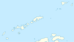 Greenwich Island Location of Greenwich Island  Greenwich Island Greenwich Island (Antarctica) | |
| Geography | |
|---|---|
| Location | Antarctica |
| Coordinates | 62°31′S 59°47′W / 62.517°S 59.783°WCoordinates: 62°31′S 59°47′W / 62.517°S 59.783°W |
| Archipelago | South Shetland Islands |
| Area | 142.7 km2 (55.1 sq mi) |
| Length | 24 km (14.9 mi) |
| Width | 5.23 km (3.25 mi) |
| Highest elevation | 625 m (2,051 ft) |
| Highest point | Momchil Peak |
| Administration | |
| Administered under the Antarctic Treaty System | |
| Demographics | |
| Population | Uninhabited |

Topographic map of Livingston Island, Greenwich, Robert, Snow and Smith Islands
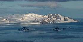
Breznik Heights, Greenwich Island from near Camp Academia, with Half Moon Island and McFarlane Strait in the foreground
Greenwich Island (variant historical names Sartorius Island, Berezina Island) is an island 24 km (15 mi) long and from 0.80 to 9.66 km (0.5 to 6 mi) (average 5.23 km or 3.25 mi) wide, lying between Robert Island and Livingston Island in the South Shetland Islands. Surface area 142.7 square kilometres (55.1 sq mi).[1] The name Greenwich Island dates back to at least 1821 and is now established in international usage.
The Chilean base Arturo Prat and the Ecuadorian base Pedro Vicente Maldonado are situated on the northeast and north coast of the island respectively.
See also
Maps
- Chart of South Shetland including Coronation Island, &c. from the exploration of the sloop Dove in the years 1821 and 1822 by George Powell Commander of the same. Scale ca. 1:200000. London: Laurie, 1822.
- L.L. Ivanov et al. Antarctica: Livingston Island and Greenwich Island, South Shetland Islands (from English Strait to Morton Strait, with illustrations and ice-cover distribution). Scale 1:100000 topographic map. Sofia: Antarctic Place-names Commission of Bulgaria, 2005.
- L.L. Ivanov. Antarctica: Livingston Island and Smith Island. Scale 1:100000 topographic map. Manfred Wörner Foundation, 2017. ISBN 978-619-90008-3-0
References
- ↑ L.L. Ivanov. Antarctica: Livingston Island and Greenwich, Robert, Snow and Smith Islands. Scale 1:120000 topographic map. Troyan: Manfred Wörner Foundation, 2010. ISBN 978-954-92032-9-5 (First edition 2009. ISBN 978-954-92032-6-4)
External links
| Wikimedia Commons has media related to Greenwich Island. |
| General |
| .svg.png) |
|---|---|---|
| Geographic regions | ||
| Waterways | ||
| Famous explorers | ||
This article is issued from
Wikipedia.
The text is licensed under Creative Commons - Attribution - Sharealike.
Additional terms may apply for the media files.