Banari Glacier
| Banari Glacier | |
|---|---|
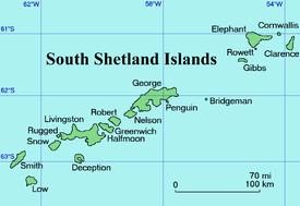 Location of Clarence Island in the South Shetland Islands | |
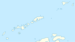 Location of Banari Glacier in Antarctica  Banari Glacier (Antarctica) | |
| Location |
Clarence Island South Shetland Islands |
| Coordinates | 61°10′35″S 54°03′50″W / 61.17639°S 54.06389°W |
| Length | 1 nautical mile (1.9 km; 1.2 mi) |
| Width | 0.6 nautical miles (1.1 km; 0.69 mi) |
| Thickness | unknown |
| Terminus | Smith Cove |
| Status | unknown |
.jpg)
Clarence Island seen from northeast with (left to right) Cape Bowles; Dobrodan Glacier and Highton Glacier surmounted by Urda Ridge; Treskavets Glacier, Orcho Glacier and Banari Glacier surmounted by Ravelin Ridge; and Cape Lloyd
Banari Glacier (Bulgarian: ледник Банари, ‘Lednik Banari’ \'led-nik ba-'na-ri\) is the 1 nautical mile (1.9 km; 1.2 mi) long and 0.6 nautical miles (1.1 km; 0.69 mi) wide glacier on the east side of Ravelin Ridge on Clarence Island in the South Shetland Islands, Antarctica situated north-northeast of Orcho Glacier. It flows northeastwards and enters Smith Cove.
The glacier is named after the settlement of Banari in Northern Bulgaria.
Location
Banari Glacier is centred at 61°10′35″S 54°03′50″W / 61.17639°S 54.06389°WCoordinates: 61°10′35″S 54°03′50″W / 61.17639°S 54.06389°W. British mapping in 1972 and 2009.
See also
Maps
- British Antarctic Territory. Scale 1:200000 topographic map. DOS 610 Series, Sheet W 61 54. Directorate of Overseas Surveys, Tolworth, UK, 1972.
- South Shetland Islands: Elephant, Clarence and Gibbs Islands. Scale 1:220000 topographic map. UK Antarctic Place-names Committee, 2009.
- Antarctic Digital Database (ADD). Scale 1:250000 topographic map of Antarctica. Scientific Committee on Antarctic Research (SCAR). Since 1993, regularly upgraded and updated.
References
- This article includes information from the Antarctic Place-names Commission of Bulgaria which is used with permission.
External links
- Bulgarian Antarctic Gazetteer. Antarctic Place-names Commission. (details in Bulgarian, basic data in English)
- Banari Glacier SCAR Composite Gazetteer of Antarctica
This article is issued from
Wikipedia.
The text is licensed under Creative Commons - Attribution - Sharealike.
Additional terms may apply for the media files.