Leti Islands
| Native name: Kepulauan Leti | |
|---|---|
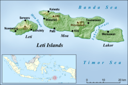 Leti Islands in the south of the Maluku Islands. | |
| Geography | |
| Location | South-east Asia |
| Archipelago | Maluku Islands |
| Major islands | Lakor, Leti, Moa |
| Administration | |
| Province | Maluku |
| Regency | Southwest Maluku |
| Demographics | |
| Languages | Indonesian, Leti |
| Additional information | |
| Time zone | |
The Leti Islands of Indonesia are part of the Maluku Islands, in southwest Maluku Province. The main islands are Moa, Leti and Lakor.
The islands cover 750 square kilometres (290 sq mi) in area and support a population of 16,664 at the 2010 Census. The most significant town is Pati, on Moa. Industries include the cultivation of rice, coconut palms and tobacco, animal husbandry, and fishing.
Leti proper, the westernmost island, has a population of 7,526. The island is a triangular mountain ridge, subtended by Koli Besar mountain in the east and the Rapat mountains in the west.
Languages
The Leti language, a member of the Austronesian languages group, is spoken on Leti.
Administration
The Leti Islands form the Leti Moa Lakor and Moa Lakor districts of the Southwest Maluku Regency within Maluku Province.
The office of the district head (camat) of Leti Moa Lakor is located in Serwaru, on the northern coast of Leti. The office of the camat of Moa Lakor is located in Weet on Moa.
See also
References
- van Engelenhoven, Aone (2004). Leti, a language of Southwest Maluku. Leiden: KITLV Press. pp. 1&ndash, 4.
External links
| Wikimedia Commons has media related to Leti Islands. |
Coordinates: 8°10′44″S 127°56′29″E / 8.178868°S 127.941284°E