Tayandu Islands
| Native name: Kepulauan Tayandu | |
|---|---|
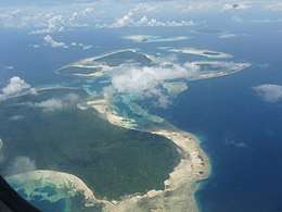 View of the Tayando Islands as seen from the air while flying between the Kai Islands and Ambon. Tayando Island plus Yamru village is in the foreground, Walir Island plus smaller Heniar (with Yamtel village) in middle distance and Taam as the largest of the isles hazily visible at the top right in the far distance. | |
| Geography | |
| Location | Southeast Asia |
| Archipelago | Maluku Islands |
| Major islands | Heniar, Tayando, Walir |
| Administration | |
| Province | Maluku |
| Additional information | |
| Time zone | |
The Tayandu or Tayando Islands (Indonesian: Kepulauan Tayando) are a group of low-lying islands just west of the larger Kai Islands of Maluku, Indonesia. The main group consists of Tayando (with villages Yamru and Ohoiel), Walir, Heniar (with village Tayando Yamtel) and several smaller isle-lets. Between Walir and Taam (further south) is Pulau Nusreen (5°42'14"S, 132°16'5"E) featuring a large sandy lagoon. Manggur is further west with Kur and Kaimeer islands north of it. Administratively they comprise a district (kecamatan) within the city of Tual.
External links
Coordinates: 5°39′07″S 132°17′22″E / 5.65194°S 132.28944°E
This article is issued from
Wikipedia.
The text is licensed under Creative Commons - Attribution - Sharealike.
Additional terms may apply for the media files.