Tanimbar Islands
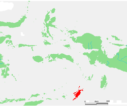
The Tanimbar Islands, also called Timur Laut, are a group of about 65 islands in the Maluku province of Indonesia, including Fordata, Larat, Maru, Molu, Nuswotar, Selaru, Selu, Seira, Wotap, Wuliaru and Yamdena. The Indonesian phrase timur laut means "east of the sea" or "northeast".
The Tanimbar Islands are administered as the Western Southeast Maluku Regency (Kabupaten Maluku Tenggara Barat in Indonesian), a regency of Maluku . The Regency covers a land area of 4,465.79 sq.km, and it had a population of 105,341 at the 2010 Census;[1] the latest official estimate (as of January 2014) was 117,341. The principal town and administrative centre lies at Saumlaki.
Geography
Geographically, the northeast islands are still part of the Lesser Sunda Islands. The Aru Islands and Kai Islands lie to the northeast, and Babar Island and Timor lie to the west. The islands separate the Banda Sea and the Arafura Sea. The total land area of the Islands is 5440 km² (2100 sq mi).
The largest of the group is Yamdena. Yamdena Island has a range of thickly forested hills along its eastern coast, while its western coast is lower. Saumlaki is the chief town, located on the south end of Yamdena. Other islands include Larat, Selaru, and Wuliaru.
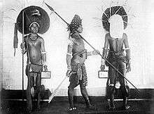
The population was 105, 341 at the 2010 Census[2], of whom about 94% are Christian, and the remainder Muslim or other.[3] The tiny island of Tanimbarkei is not part of Tanimbar, but of the Kai Islands and inhabited by less than 1000 very traditional people.
The Tanimbar Islands are part of the Banda Sea Islands moist deciduous forests ecoregion.
History
In modern history, the Tanimbar islands (as the Aru Islands) were mentioned in the 16th century maps of Lázaro Luís (1563), Bartolomeu Velho (c. 1560), Sebastião Lopes (1565), in the 1594 map of the East Indies entitled Insulce Molucoe by the Dutch cartographer Petrus Plancius, and in the map of Nova Guinea of 1600 (based on Portuguese sources). The Tanimbar Islands were sighted and possibly visited by Portuguese navigators such as Martim Afonso de Melo Jusarte around 1522–1525, who traveled around the archipelagos of Aru (with the reference "Here wintered Martin Afonso de Melo") and Tanimbar, and possibly Gomes de Sequeira in 1526.[4]
The Tanimbar Islands were part of the Dutch East Indies. During World War II the Dutch sent a detachment of thirteen men to the town of Saumlaki in the Tanimbar Islands in July 1942. Japanese ships entered the bay at Saumlaki on 30 July and small boats were used to get to the jetty. The Japanese filed in ranks on the jetty and wanted to march in close order into Saumlaki. The garrison opened fire at close range with their two light machine guns. The Japanese retreated to their boats leaving several dead on the jetty.
On 31 July an Australian contingent arriving at the jetty at Saumlaki in order to support the Dutch garrison was fired on from the shore, and the commander on board was killed. The Australians returned to Darwin. Next, the garrison came under naval gunfire, which inflicted some casualties, followed by a second attack on a wider front. Seven survivors withdrew and boarded a sailing ship and escaped to Australia.[5]
Economy
Important products are copra, tortoiseshell, and trepang (an edible sea cucumber).
Fauna
See also
Notes
- ↑ Biro Pusat Statistik, Jakarta, 2011.
- ↑ "Population by Region, Type of Document, and Sex". Badan Pusat Statistik. Retrieved 29 June 2017.
- ↑ "Population by Region and Religion". Badan Pusat Statistik. Retrieved 29 June 2017.
- ↑ Continent of Curiosities: A Journey Through Australian Natural History - Danielle Clode, Cambridge University Press, Page 26
- ↑ L, Klemen (1999–2000). "The Banda Sea Operations 1941-1942". Forgotten Campaign: The Dutch East Indies Campaign 1941-1942.
References
- L, Klemen (1999–2000). "Forgotten Campaign: The Dutch East Indies Campaign 1941-1942".
External links
| Wikimedia Commons has media related to Tanimbar Islands. |