Transport in Indonesia
Indonesia's transport system has been shaped over time by the economic resource base of an archipelago with thousands of islands, and the distribution of its more than 200 million people highly concentrated on a single island, Java.[1]
All transport modes play a role in the country’s transport system and are generally complementary rather than competitive. Road transport is predominant, with a total system length of est. 438,000 kilometres (272,000 miles) in 2008. The railway system has four unconnected networks in Java and Sumatra primarily dedicated to transport bulk commodities and long-distance passenger traffic.
Sea transport is extremely important for economic integration and for domestic and foreign trade. It is well developed, with each of the major islands having at least one significant port city. The role of inland waterways is relatively minor and is limited to certain areas of Eastern Sumatra and Kalimantan. The function of air transport is significant, particularly where land or water transport is deficient or non-existent. It is based on an extensive domestic airline network where all major cities can be reached by passenger plane.
Water transport
Merchant marine vessels

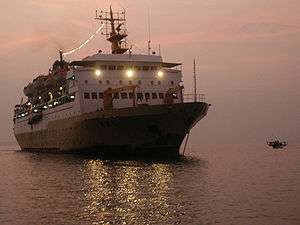
Because Indonesia encompasses a sprawling archipelago, maritime shipping provides essential links between different parts of the country. Boats in common use include large container ships, a variety of ferries, passenger ships, sailing ships, and smaller motorised vessels. Traditional wooden vessel pinisi still widely used as the inter-island freight service within Indonesian archipelago. Main pinisi traditional harbours are Sunda Kelapa in Jakarta and Paotere harbour in Makassar.
Frequent ferry services cross the straits between nearby islands, especially in the chain of islands stretching from Sumatra through Java to the Lesser Sunda Islands. On the busy crossings between Sumatra, Java, and Bali, multiple car ferries run frequently twenty-four hours per day. There are also international ferry services between across the Straits of Malacca between Sumatra and Malaysia, and between Singapore and nearby Indonesian islands, such as Batam.
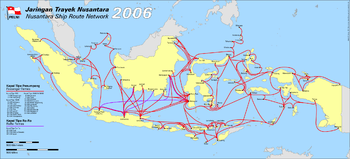
A network of passenger ships makes longer connections to more remote islands, especially in the eastern part of the archipelago. The national shipping line, Pelni, provides passenger service to ports throughout the country on a two to four week schedule. These ships generally provide the least expensive way to cover long distances between islands. Still smaller privately run boats provide service between islands.
On some islands, major rivers provide a key transportation link in the absence of good roads. On Kalimantan, longboats running on the rivers are the only way to reach many inland areas.
Waterways
Indonesia has 21,579 km of navigable waterways (As of 2005), of which about one half are on Kalimantan, and a quarter each on Sumatra and Papua. Waterways are highly needed because the rivers on these islands are not wide enough to hold medium-sized ships. In addition to this, roads and railways are not good options since Kalimantan and Papua are not like Java, which is a highly developed island.[2] With the current length of waterways, Indonesia ranked seventh on the countries with longest waterways.[3]
Ports and harbours
Major ports and harbours include Bitung, Cilacap, Cirebon, Jakarta, Kupang, Palembang, Semarang, Surabaya, and Makassar. Ports are managed by the various Indonesia Port Corporations, of which there are four, numbered I through IV. Each has jurisdiction over various regions of the country, with I in the west and IV in the east. Port of Tanjung Priok in Jakarta is the Indonesia's busiest port, handling over 5.20 million TEUs.[4] A two-phase "New Tanjung Priok" extension project is currently underway, which will triple the existing annual capacity when fully operational in 2023. In 2015, ground breaking of the strategic North Sumatra's Kuala Tanjung Port has been completed. It is expected to accommodate 500,000 TEUs per year,[5] overtaking Johor's Tanjung Pelepas Port and could even compete with the port of Singapore.[6]
Roads and highways
A wide variety of vehicles are used for transportation on Indonesia's roads. Bus services are available in most areas connected to the road network. Between major cities, especially on Sumatra, Java, and Bali, services are frequent and direct; many services are available with no stops until the final destination. In more remote areas, and between smaller towns, most services are provided with minibuses or minivans (angkut). Buses and vans are also the primary form of transportation within cities. Often, these are operated as share taxis, running semi-fixed routes.
Many cities and towns have some form of transportation for hire available as well such as taxis. There are usually also bus services of various kinds such as the Kopaja buses and the more sophisticated Transjakarta bus rapid transit system in Jakarta, the longest bus rapid transit (BRT) system in the world that boasts some 230.9 kilometres (143.5 miles) in 13 corridors and 10 cross-corridor routes[7] and carrying 430,000 passengers daily in 2016.[8] Other cities such as Yogyakarta, Palembang, Bandung, Denpasar, Pekanbaru, Semarang, Makassar, and Padang also have BRT systems in place without segregated lanes. Many cities also have motorised autorickshaws (bajaj) of various kinds. Cycle rickshaws, called becak in Indonesia, are a regular sight on city roads and provide inexpensive transportation. They have been blamed for causing traffic congestion and, consequently, banned from most parts of Jakarta in 1972.[9] Horse-drawn carts are found in some cities and towns.

Due to the increasing purchasing power of Indonesians, private cars are becoming more common especially in major cities. However the growth of the number of cars increasingly outpaces the construction of new roads, resulting in frequently crippling traffic jams in large parts in major cities especially in Jakarta, which often also happen on highways. Jakarta also has one of the worst traffic jams in the world.[10]
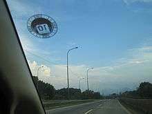
Indonesia has about 283,102 kilometres (175,911 mi) of paved highways and 213,505 kilometres (132,666 mi) of unpaved highways (As of 2011 estimate).[11] The AH2 highway is one of Indonesia's main highways. The other one is AH25 in Sumatra. Indonesia has some highways, some of them are National Routes (25, currently only in Java and (partially) Sumatera), and some of them are freeways. All the freeways are tolled (toll road). The first toll road in Indonesia is the Jagorawi Toll Road, opened in 1978.[12] The construction of toll roads has accelerated under President Joko Widodo, with 568 kilometres (353 mi) of toll roads opened during his term, more than any previous presidents.[12] The most expensive is the Cipularang Toll Road that connects Jakarta and Bandung via Cikampek and Purwakarta.
Indonesia has also been gradually introducing an Intelligent Transportation System (ITS) since 2012. ITS Indonesia was formed on 26 April 2011.[13]
National routes
National routes of Indonesia pass through most of main cities heart and designed to connect between city centers. They act as main intercity route outside the tollways. A national route has to be passable by logistic trucks, while handling the huge traffic at the same time. National routes in Java are numbered, while national routes outside Java has not been numbered. In some cities, even in crowded districts, national routes often form bypasses or ring roads (Indonesian: jalan lingkar) around the city to prevent intercity traffic entering the city center.
Ministry of Public Works is responsible to these networks, except DKI Jakarta part from Jakarta Inner Ring Road to Jakarta Outer Ring Road. A national route can be revised due to inability to handle traffic, it is usually given to the province.
Toll roads
Java
Sumatra
- Belawan-Medan-Tanjung Morawa Toll Road (Belmera Toll Road)
Planned :
- Medan-Kuala Namu International Airport-Tebing Tinggi, 80 percent of the land needed for the toll road construction is owned by state plantation which it is easy to take over, whether the remaining 20 percent is owned by local residents which it is difficult to take over due to unreasonably high prices.[14]
- Medan-Binjai Toll Road[15]
- Pekanbaru-Kandis-Duri-Dumai Toll Road[15]
- Palembang-Indralaya Toll Road[15]
- Tegineneng-Babatan Toll Road[15]
Sulawesi
- Makassar-Sultan Hasanuddin International Airport Toll Road
- Makassar Section 1,2,3,4 Toll Road
Planned:
- Manado-Bitung Toll Road[15]
Bali
The toll road between Tanjung Benoa to Airport and from Airport to Serangan, all in direct line (not curve) is 12.7 kilometres and is equipped also with motorcycle lanes. The toll road is formally opened on 23 September 2013, about a week before APEC Summit in Bali is opened.[16]
Railways

The majority of Indonesia's railways is located on Java, used for both passenger and freight transport. The railway is operated by Kereta Api Indonesia. The inter-city rail network on Java is complemented by local commuter rail services in the Jakarta metropolitan area and in Surabaya. In Jakarta, the commuter rail service (Kereta Commuter Indonesia) carries 885,000 passengers a day.[17] In addition, a mass rapid transit system is under construction in Jakarta, and light rail transit systems are currently under construction in Jakarta and Palembang.[18][19] There are four separate railway networks on Sumatra: one in Aceh, one in North Sumatra (Aceh connection proposed to be finished in 2020s), another in West Sumatra, and the final one in South Sumatra and Lampung. South Sulawesi has railway network in Barru Regency as the impact of Trans-Sulawesi Railway construction, although the network has not been used yet. [20]There are no railways in other parts of Indonesia, although new networks are being developed on Kalimantan[21] and Sulawesi.[22] The government's plan to build a high-speed rail (HSR) was announced in 2015, the first in Indonesia and Southeast Asia. It is expected to connect the capital Jakarta with Bandung, covering a distance of around 140 kilometres (87 miles). Plans were also mentioned for its possible extension to Surabaya, the country's second largest city.[23]
Pipelines
As of 2013, Indonesia has pipelines for condensate 1,064 km (661 mi), condensate/gas 150 km (93 mi), gas 11,702 km (7,271 mi), liquid petroleum gas 119 km (74 mi), oil 7,767 km (4,826 mi), oil/gas/water 77 km (48 mi), refined products 728 km (452 mi), and water 44 km (27 mi).[24]
Air transport
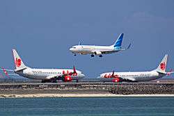
Air transport in Indonesia serves as a critical means of connecting the thousands of islands throughout the archipelago. Indonesia is the largest archipelagic country in the world, extending 5,120 km (3,181 mi) from east to west and 1,760 km (1,094 mi) from north to south,[25] comprising 13,466 islands,[26] with 922 of those permanently inhabited.[lower-alpha 1] With an estimated population of over 255 million people — making it the world's fourth-most-populous country — and also due to the growth of the middle-class, the boom of low-cost carriers in the recent decade, and overall economic growth, many domestic travellers shifted from land and sea transport to faster and more comfortable air travel.[27] Indonesia is widely regarded as an emerging market for air travel in the region. Between 2009 and 2014, the number of Indonesian air passengers increased from 27,421,235[28] to 94,504,086,[29] an increase of over threefold.[29]
However, safety issues continue to be a persistent problem in Indonesian aviation.[27] Several accidents have given Indonesia's air transport system the reputation of the least safe in the world.[30] Indonesian aviation faces numerous challenges, including poorly maintained, outdated, and often overwhelmed infrastructure, the factor of human error, bad weather, haze problems caused by plantation fires, and volcanic ash spewed by numerous volcanoes that disrupts air transportation.[31][32][33]
The Indonesian Air Force has 34,930 personnel equipped with 224 aircraft, among them 110 combat aircraft. The Indonesian Air Force possesses and operates numerous military air bases and military airstrips across the archipelago.[34]
The International Air Transport Association (IATA) has predicted that Indonesia will become the world's sixth largest air travel market by 2034.[35] Around 270 million passengers are predicted to fly from and within Indonesia by 2034.[35]
Airports

As of 2013, there are 673 airports in Indonesia, 186 of those have paved runways, and 487 have unpaved runways.[11] As of 2013, there are 76 heliports in Indonesia.[11] Jakarta's Soekarno–Hatta International Airport serves as the country's main air transportation hub as well as the nation's busiest. Since 2010, it has become the busiest airport in Southeast Asia, surpassing Suvarnabhumi and Changi airports. In 2017, it became the 17th busiest airport in the world with 62.1 million passengers.[36] Today the airport is running over capacity. After an expansion with a third terminal was completed in 2016, the total capacity of the three terminals increased to 43 million passengers a year. The first and second terminals will be revitalised in order to accommodate 67 million passengers a year.[37]
Airlines
In Indonesia, there are 22 commercial scheduled airlines that carry more than 30 passengers, and 32 commercial scheduled airlines that transport 30 or less passengers, as well as chartered airlines.[38][39] Some notable Indonesian airlines, among others, include Garuda Indonesia, the government-owned flag carrier of Indonesia, Lion Air, currently the largest private low-cost carrier airline in Indonesia, Sriwijaya Air, currently the largest medium service regional carrier in Indonesia, also the country's third largest carrier, and Indonesia AirAsia, the Indonesian branch of Malaysian-based AirAsia.[40]
Mudik

Mudik, or Pulang Kampung, is an Indonesian term for the activity where migrants or migrant workers return to their hometown or village during or before major holidays, especially Lebaran (Eid al-Fitr).[41] Although the mudik homecoming travel before Lebaran takes place in most Indonesian urban centers, the highlight is on the nation's largest urban agglomeration; Greater Jakarta, as millions of Jakartans exit the city by various means of transportation, overwhelming train stations and airports and also clogging highways, especially the Trans-Java toll road and Java's Northern Coast Road.[42] In 2017 it was estimated that the people that took annual mudik travel reached 33 million people.[43] The demand for train and airplane tickets usually spikes a month or two prior to Lebaran, prompting an unusually higher cost for tickets for highly sought days of departure. Some airlines might add extra flights or operate larger airplanes to deal with the surge in demand.[44] Indonesian train operator Kereta Api Indonesia usually offers additional train trips or introduces longer trains with more cars in order to meet the demand.[45] The private operators of intercity and interprovince buses usually charge higher ticket costs during this period. The impact is indeed tremendous as millions of buses, cars and motorcycles jam the roads and highways, causing kilometres of traffic jams each year.[46][47]
See also
Notes
References
- ↑ Legge, John D. (April 1990). "Review: Indonesia's Diversity Revisited". Indonesia. 49: 127–131. JSTOR 3351057.
- ↑ Guerin, Bill (21 July 2006). "Politics and Business Mix in Indonesia". Kerry B. Collison. Archived from the original on 10 May 2008.
- ↑ "Rank Order - Waterways". The World Factbook. Central Intelligence Agency. Retrieved 2 April 2018.
- ↑ "Top 50 World Container Ports". World Shipping Council. 2015. Archived from the original on 15 November 2017. Retrieved 15 November 2017.
- ↑ "Pelindo I Needs IDR 34 Trillion to Run Kuala Tanjung Port Project". Nusantara Maritime News. 28 May 2015. Archived from the original on 14 May 2017. Retrieved 12 January 2018.
- ↑ Amin, Khoirul (22 January 2015). "Pelindo has high hopes for Kuala Tanjung". The Jakarta Post. Archived from the original on 20 October 2016. Retrieved 20 October 2016.
- ↑ "Koridor". TransJakarta. Retrieved 15 August 2017.
- ↑ Tristia Tambun, Lenny (25 January 2017). "This Year, TransJakarta targets 185 million passengers" (in Indonesian). Berita Satu. Archived from the original on 15 August 2017. Retrieved 15 August 2017.
- ↑ Purba, David Oliver (15 January 2018). "Penghapusan Operasional Becak di Jakarta, dari 1936 hingga Kini..." Kompas (in Indonesian). Retrieved 1 April 2018.
- ↑ "Jakarta – Urban Challenges Overview – Human Cities Coalition". Human Cities Coalition. 25 January 2017. Retrieved 1 April 2018.
- 1 2 3 "Indonesia". The World Factbook. Central Intelligence Agency. Retrieved 1 April 2018.
- 1 2 Damayanti, Annisa Ulva (4 March 2018). "Potret Pembangunan Tol di Indonesia, dari Soeharto hingga Jokowi". Okezone News (in Indonesian). Retrieved 24 April 2018.
- ↑ "RI to adopt ITS gradually starting in 2012". Antara. 25 July 2011. Retrieved 1 April 2018.
- ↑ Widhiarto, Hasyim (25 April 2011). "'Made in Indonesia' airport construction may last forever". The Jakarta Post. Archived from the original on 11 May 2011.
- 1 2 3 4 5 "Profil Rencana Jalan Tol" (in Indonesian). Badan Pengatur Jalan Tol. Archived from the original on 25 May 2009.
- ↑ "Awaiting an Opening". Bali Update. 22 September 2013. Retrieved 2 April 2018.
- ↑ Diana, Lani; Sugiharto, Jobpie (11 August 2016). "KRL passengers rise by 105% in 3 years" (in Indonesian). Tempo. Archived from the original on 18 August 2017. Retrieved 18 August 2017.
- ↑ "MRT and LRT, Jakarta's New Rapid Transportation: Coming Soon". Indo Indians. 25 September 2017. Archived from the original on 17 January 2018. Retrieved 17 January 2018.
- ↑ Alexander, Hilda B. (22 October 2016). "Palembang LRT to begin operation in June 2018" (in Indonesian). Kompas. Archived from the original on 29 October 2016. Retrieved 29 October 2016.
- ↑ "Proyek KA Makassar-Parepare Tetap Lanjut, Soni: Kemenhub Tidak Proaktif Laporkan Proses Pengerjaan" [Makassar-Parepare Railway Continues, Soni: No Proactive Reports From Transport Ministry]. Fajar.co.id (in Indonesian). Retrieved 20 June 2018.
- ↑ New railway on Kalimantan
- ↑ "Menhub: Akhir 2018, Kereta Api Trans Sulawesi Capai 44 KM" (in Indonesian). Ministry of Transportation. 28 October 2017. Retrieved 25 March 2018.
- ↑ Istianur Praditya, Ilyas (25 September 2017). "Jakarta-Surabaya High-Speed Rail Project to begin in 2018". Liputan6.com (in Indonesian). Archived from the original on 27 September 2017. Retrieved 27 September 2017.
- ↑ "The World Factbook — Central Intelligence Agency". www.cia.gov. Retrieved 2018-10-02.
- ↑ Kuoni - Far East, A world of difference. Page 88. Published 1999 by Kuoni Travel & JPM Publications
- ↑ "Hanya ada 13.466 Pulau di Indonesia". National Geographic Indonesia (in Indonesian). 8 February 2012.
- 1 2 "Can Indonesia and air safety become synonymous by 2019?". aerotime.aero. Retrieved 2018-02-27.
- ↑ "Air transport, passengers carried, Indonesia 2009". The World Bank.
- 1 2 "Data: Air transport, passengers carried". The World Bank.
- ↑ "Safety woeful, admits air chief". The Sydney Morning Herald. 2 November 2007. Retrieved 1 April 2018.
- ↑ Maria Yuniar (18 September 2013). "Deregulasi Penerbangan Picu Kepadatan Bandara". Tempo (in Indonesian).
- ↑ Vaswani, Karishma (12 October 2015). "Indonesia's costly haze problem". BBC News. Retrieved 6 November 2015.
- ↑ "Indonesia volcanic ash causes new Bali airport closure". BBC News. 12 July 2015. Retrieved 26 October 2015.
- ↑ "World Air Forces 2015" (PDF). Flightglobal.com (pdf).
- 1 2 Tyler, Tony (12 March 2015). "Developing the Potential of Indonesia's Aviation Sector". International Air Transport Association (IATA). Retrieved 6 November 2015.
- ↑ "Soekarno-Hatta world's 17th busiest airport". The Jakarta Post. Archived from the original on 11 April 2018. Retrieved 11 April 2018.
- ↑ "Agar Penumpang Lebih Aman dan Nyaman di Bandara Soekarno-Hatta" (in Indonesian). Kompas. 17 November 2014. Archived from the original on 27 December 2016. Retrieved 27 December 2016.
- ↑ "Daftar Maskapai". Direktorat Jenderal Perhubungan Udara, Kementerian Perhubungan Republik Indonesia (in Indonesian).
- ↑ (in Indonesian) AOC 121 & 135 definition
- ↑ "Daftar Nama Maskapai Penerbangan yang Beroperasi di Indonesia". Bandara Soekarno-Hatta (in Indonesian). 18 February 2015. Retrieved 8 December 2015.
- ↑ Donny Syofyan (13 July 2015). "Lebaran and local pride in the annual 'mudik' custom". The Jakarta Post.
- ↑ Callistasia Anggun Wijaya (1 July 2016). "Mass exodus to begin in Jakarta this weekend". The Jakarta Post. Jakarta.
- ↑ Septian Deny. "Jumlah Pemudik 2017 Diprediksi Mencapai 33 Juta Orang". liputan6.com (in Indonesian). Retrieved 2017-12-11.
- ↑ "Airlines Ajukan 90 Extra Flight untuk Lebaran". CNBC Indonesia (in Indonesian). 25 April 2018. Retrieved 9 June 2018.
- ↑ Bempah, Ramdhan Triyadi (4 May 2018). "PT KAI Siapkan 16 Kereta Tambahan untuk Antisipasi Lonjakan Pemudik". Kompas (in Indonesian). Retrieved 9 June 2018.
- ↑ "Govt says roads ready for Lebaran exodus". The Jakarta Post. 1 September 2010. Retrieved 2 September 2010.
- ↑ Sri Lestari (7 July 2016). "Mudik gratis 'tak berhasil' kurangi jumlah pengendara sepeda motor". BBC Indonesia (in Indonesian).
| History |  | ||||||
|---|---|---|---|---|---|---|---|
| Geography |
| ||||||
| Politics | |||||||
| Economy | |||||||
| Culture |
| ||||||
Transport in Asia | |
|---|---|
| Sovereign states |
|
| States with limited recognition |
|
| Dependencies and other territories |
|
| |