List of islands of Kuwait

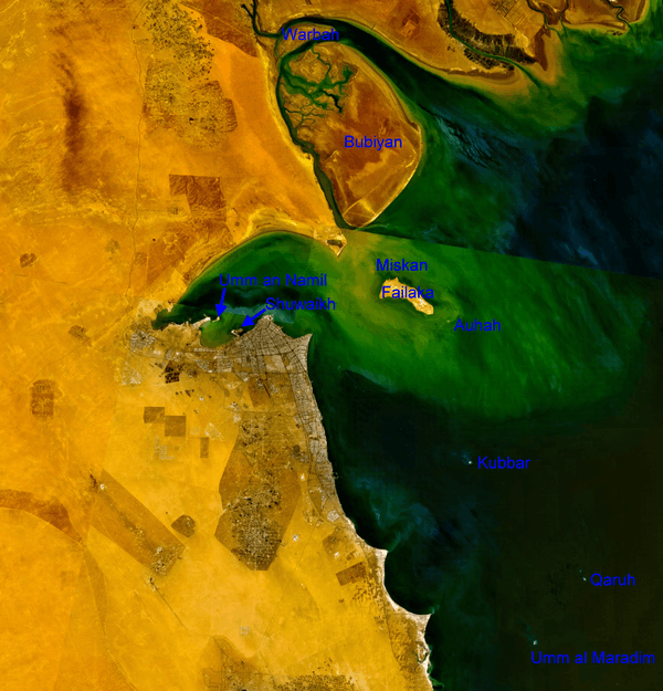
This is a list of islands of Kuwait. Kuwait has nine Islands (ten including one former island). They are indicated on the NASA satellite image and listed in the table in order from north to south:

NASA Visible Color Satellite Image with islands of Kuwait
IslandArabicArea km²Coordinates
northern mudflat islands (Al Jahra Governorate)
Warbah Islandجَزِيرَة وَرْبَة37      29°59′38″N 48°04′00″E / 29.99389°N 48.06667°E / 29.99389; 48.06667
Bubiyan Islandجَزِيرَة بُوبِيَان863      29°44′41″N 48°21′03″E / 29.74472°N 48.35083°E / 29.74472; 48.35083
Failaka with satellite islands (Al Asimah Governorate)
Miskan Islandجَزِيرَة مِسْكَان0.75  29°29′05″N 48°15′05″E / 29.48472°N 48.25139°E / 29.48472; 48.25139
Failaka Islandجَزِيرَة فَيْلَكَا20      29°26′26″N 48°20′05″E / 29.44056°N 48.33472°E / 29.44056; 48.33472
Auhah Islandجَزِيرَة عَوْهَة0.35  29°22′40″N 48°26′21″E / 29.37778°N 48.43917°E / 29.37778; 48.43917
islands of Kuwait Bay (Al Asimah Governorate)
Umm an Namil Islandجَزِيرَة أُمّ اَلنَّمْل0.30  29°22′54″N 47°52′01″E / 29.38167°N 47.86694°E / 29.38167; 47.86694
Shuwaikh Island1)جَزِيرَة قُرَيْن0.01229°21′16″N 47°54′35″E / 29.35444°N 47.90972°E / 29.35444; 47.90972
southern islands (Al Ahmadi Governorate)
Kubbar Islandجَزِيرَة كُبَّر0.11  29°04′20″N 48°29′36″E / 29.07222°N 48.49333°E / 29.07222; 48.49333
Qaruh Islandجَزِيرَة قَارُوه0.03528°49′03″N 48°46′35″E / 28.81750°N 48.77639°E / 28.81750; 48.77639
Umm al Maradim Islandجَزِيرَة أُمّ اَلْمَرَادِم0.65  28°40′42″N 48°39′10″E / 28.67833°N 48.65278°E / 28.67833; 48.65278
Islands of Kuwait 922       
1) former island

See also

This article is issued from Wikipedia. The text is licensed under Creative Commons - Attribution - Sharealike. Additional terms may apply for the media files.