North Sulawesi
| North Sulawesi Sulawesi Utara | |||
|---|---|---|---|
| Province | |||
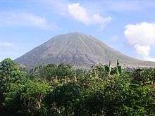    .jpg) 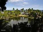 Clockwise, from top left : The view of Mount Tumpa from Malalayang Beach, Lake Tondano, Teluk Buyat Beach, Bentenan Beach, A landscape in North Sulawesi, Bunaken and Manado Tua, Mount Lokon | |||
| |||
|
Motto(s): Si Tou Timou Tumou Tou (Minahasan) (Human purpose in life is to nurture and educate others) | |||
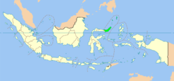 Location of North Sulawesi in Indonesia | |||
| Coordinates: 1°15′N 124°50′E / 1.250°N 124.833°ECoordinates: 1°15′N 124°50′E / 1.250°N 124.833°E | |||
| Country | Indonesia | ||
| Established | 14 August 1959 | ||
| Founded by | Sam Ratulangi | ||
| Capital |
| ||
| Government | |||
| • Body | North Sulawesi Regional Government | ||
| • Governor | Olly Dondokambey (PDI-P) | ||
| • Vice Governor | Steven Kandouw | ||
| Area | |||
| • Total | 13,851.64 km2 (5,348.15 sq mi) | ||
| Area rank | 27th | ||
| Highest elevation | 1,995 m (6,545 ft) | ||
| Population (2014)[1] | |||
| • Total | 4,353,900 | ||
| • Density | 310/km2 (810/sq mi) | ||
| Demographics | |||
| • Ethnic groups | Minahasan, Mongondow, Sangirese, Talaud, Gorontaloan, Chinese, Bugis, Javanese | ||
| • Religion | Protestantism (63.6%), Islam (30.9%), Roman Catholicism (4.4%), Hinduism (0.58%), Buddhism (0.14%), Confucianism (0.02%), Judaism | ||
| • Languages |
Indonesian (official) Manado Malay (lingua franca) Regional languages: Bantik, Bintauna, Mongondow, Ratahan, Sangirese, Talaud, Tombulu, Tondano, Tonsawang, Tonsea, Tontemboan | ||
| Time zone | UTC+8 (Indonesia Central Time) | ||
| Postcodes | 90xxx, 91xxx, 92xxx | ||
| Area codes | (+62) 4xx | ||
| ISO 3166 code | ID-SA | ||
| Vehicle registration | DB, DL (Sangihe & Talaud Islands) | ||
| HDI |
| ||
| HDI rank | 7th (2015) | ||
| Largest city by area | Bitung – 302.89 square kilometres (116.95 sq mi) | ||
| Largest city by population | Manado – (675,411 – 2010) | ||
| Largest regency by area | Bolaang Mongondow Regency – 2,871.65 square kilometres (1,108.75 sq mi) | ||
| Largest regency by population | Minahasa Regency – (1,710,384 – 2010) | ||
| Website | Government official site | ||

North Sulawesi (Indonesian: Sulawesi Utara) is a province of Indonesia. It is located on the northern peninsula of the island of Sulawesi, on the Minahasa Peninsula, lies south of Philippines and southeast of Malaysia. It borders Philippines to the north, the Maluku Sea to the east, Gorontalo to the west and the Gulf of Tomini to the south. The province's capital and largest city is Manado, and its population was 4,135,526 according to the 2010 census;[2] the latest official estimate (for January 2014) is 4,353,540. Manado is also the main gateway and the economic center of the province. Other major towns includes Tomohon and Bitung. There are 41 mountains with an altitude ranging from 1,112–1,995 metres (3,648–6,545 ft). Most geologic conditions are the young volcanic region, a large number of eruptions and the active cone shape of the active volcanoes that adorn the central Minahasa, Bolaang Mongondow and Sangihe Islands.
North Sulawesi in the past was an area of potential spices, rice and gold which became a battleground for the interests of economic hegemony between the Portuguese, Spanish, Dutch and the Kingdoms around this area, which ultimately led to political and military struggles. The past of this region also became the trading route between west and east and the spread of Christianity, Islam and belief or religion brought by Chinese merchants. The Portuguese first landed on the area at the 16th century. Following decades of war between the Portuguese, the Spanish and the Dutch to control the area, the area ultimately fell to the Dutch at the 17th century. The Dutch ruled the area for three centuries, before being ousted by the Japanese on the eve of World War II. Following the Japanese surrender in 1945, the Dutch briefly regained possession of the area, before finally leaving for good in 1949, following the Round Table Conference, in which the Dutch recognized the newly created United States of Indonesia (RIS). Thus, North Sulawesi was incorporated into the territory of the State of East Indonesia (NIT). Because it was not in accordance with the will of the people, NIT was finally dissolved and then merged into the Republic of Indonesia. On 17 August 1950, the RIS was officially disbanded and then re-formed as the Unitary State of the Republic of Indonesia. The island of Sulawesi was governed briefly as a single province, before being separated into several different provinces. Thus, the province of North Sulawesi was created on 14 August 1959.
Etymology
The area in what is now known as North Sulawesi is used to be called Minahasa. The name is still used sometime to refer to the province. The word Minahasa is etymologically derived from the words Mina-Esa (Minaesa) or Maesa which means being one or uniting, meaning hope to unite various sub-ethnic groups of Minahasa consisting of Tontemboan, Tombulu, Tonsea, Tolour (Tondano), Tonsawang, Ponosakan, Pasan, And Bantik. The word "Minahasa" itself was only used during the colonial eta. "Minahasa" is generally interpreted as "having become one". Based on several historical documents, the word "Minahasa" it firstly used by J.D. Schierstein, the Dutch regent of Manado, in his report to the Governor of Maluku on 8 October 1789. The word "Minahasa" in his report is defined as Landraad or "State Council" or "Regional Council".
History
Pre-Colonial Era
Archaeological research has revealed signs of human life in North Sulawesi since 30,000 years ago, based on evidence in the cave Liang Sarru on the island of Salibabu. Other evidence shows life about 6,000 years ago on the Passo Hillside Site in Kakas Sub-district and 4,000 years ago to early AD at the Liang Tuo Mane'e cave in Arangkaa on Karakelang Island.
Colonial Period
At the end of the 16th century, Portuguese and Spanish arrived in North Sulawesi. As Europeans arrived, the Ternate Sultanate had an influence in North Sulawesi, frequented by Bugis traders from South Sulawesi. The wealth of Minahasa's natural resources makes Manado a strategic port for European traders going to and from Maluku. The Portuguese nation was the first western nation to arrive in North Sulawesi, a Portuguese ship anchored on the island of Manado in the Kingdom of Manado in 1521. The Spanish ship docked on the island of Talaud and Siau, on to Ternate. The Portuguese built the fort at Amurang. Spain built the Fort in Manado, since then Minahasa started in control of Spain. The resistance against the Spanish occupation culminated in 1660–1664. The Dutch ship landed in Manado City in 1660 in assisting the struggle of the Minahasa Confederation against Spain. The United Nations republican association of members of the Minahasa Confederation entered into a Trade Agreement with the VOC. This trade cooperation agreement then made the VOC monopolize the trade, which gradually began to impose its will, eventually leading to the 1700s resistance in Ratahan which culminated in the Dutch Minahasa-War in 1809–1811 at Tondano.
The Spanish had colonized the Philippine Islands at the time and Minahasa was made a coffee plantation imported from South America because of its fertile Minahasa land. Manado was further developed by Spain to become a center of coffee trade for Chinese merchants. With the help of Minahasan tribes who became allies, Spain captured the Portuguese fort at Amurang in the 1550s, and the Spanish colonists then built the fort in Manado, so that eventually Spain controlled all Minahasa. In the 16th century one of the first Indo-Eurasian communities in the archipelago appeared in Manado. The first king of Manado, Muntu Untu (1630) is actually a half Spanish ancestry. Spain then handed over Minahasa to the Portuguese in exchange for 350,000 ducats in a treaty. The rulers of Minahasa sent Supit, Pa'at, and Lontoh to ally with the Dutch to expel the Portuguese from Minahasa. In 1655 they finally excelled, built their own fortress in 1658 and drove out the last Portuguese a few years later. By the beginning of the 17th century the Dutch had overthrown the sultanate of Ternate, and began to close the influence of Spain and Portugal in the archipelago. In 1677 the Dutch conquered the Sangir archipelago and, two years later, Robert Padtbrugge, the governor of Maluku, visited Manado. His arrival resulted in an agreement with the Minahasan chiefs who led to Dutch domination for the next 300 years although the direct rule by the Dutch only began in 1870. The Dutch helped unify the Minahasa confederation, and in 1693 the Minahnians obtained an absolute military victory against the Mongondow tribe in the south. Dutch influence flourished with the development of Christianity and European culture in the land of Minahasa. The missionary schools in Manado in 1881 were one of the first attempts of mass education in Indonesia, providing an opportunity for graduates to find employment as civil servants, army, and other high positions in the Dutch East Indies government. Minahasa relations with the Dutch are often poor. There was a war between the Dutch and Tondano in 1807 and 1809, and the Minahasa territory was not under Dutch direct rule until 1870. But eventually the Dutch and Minahasa became very close to Minahasa often referred to as the 12th Dutch province. Even in 1947, Manado formed the political movement of Twapro, short for Twaalfde Profincie (Twelfth Province) who appealed for formal integration of Minahasa into the Kingdom of the Netherlands.
Independence
The Japanese occupation of 1942–45 was a period of deprivation, and the allied forces bombed Manado greatly in 1945. During the period of independence thereafter, there was a split between pro-Indonesian and pro-Dutch Minahasa. The appointment of Sam Ratulangi as the first East Indonesia governor then succeeded in winning Minahasa support to the Republic of Indonesia. After Indonesian independence, Indonesia is divided into 8 Provinces, and Sulawesi is one of these provinces. Sulawesi's first governor was S.G.J.Ratulangi, also known as a national hero. In 1948 in Sulawesi was formed the State of East Indonesia, which later became one of the states within the United States of Indonesia. The State of East Indonesia was dissolved, and merged into the Republic of Indonesia. Based on Law Number 13 Year 1964, formed North Sulawesi Province. 14 August 1959 was designated as the anniversary of the province.
In March 1957, North and South Sulawesi military leaders held a confrontation with Java, with demands for greater regional autonomy. They called for more active development, a fairer distribution of taxes, assistance against Kahar Muzakar's rebellion in South Sulawesi, and a central government cabinet headed by Sukarno and Hatta in balance. At first the movement of the 'Permesta' (Charter of the Struggle of the Universe) was merely a movement of reform rather than a separatist movement.
Negotiations between the central government and Sulawesi military leaders prevented violence in South Sulawesi, but Minahasan leaders were not satisfied with the outcome of the agreement and the movement broke out. Fearful of southern dominance, Minahasan leaders declared their own North Sulawesi autonomous state in June 1957. At that time the central government had controlled South Sulawesi, but in the North there were no strong figures of the central government and there were rumors that the United States was armed with rebellion in Sumatra North, also has links with Minahasan leaders.
The possibility of foreign intervention prompted the central government to request military assistance from southern Sulawesi. The Permesta forces were later removed from Central Sulawesi, Gorontalo, Sangir, and Morotai in Maluku. Permesta planes (supplied by the US and flown by Philippine, Taiwanese, and American Pilots) were destroyed. The US then moved on, and in June 1958 the central government army landed in Minahasa. The Permesta uprising ended in mid-1961.
The effects of the Sumatra and Sulawesi rebellions ultimately increased what the rebels wanted to fight against. Central government authority increased while regional autonomy weakened, radical nationalism strengthened than pragmatic moderation, communist party power and Sukarno increased while Hatta weakened, and Sukarno finally established guided democracy in 1958.
Since the 1998 reforms, the Indonesian government has begun to adopt laws that enhance regional autonomy, the main idea that Permesta fights for.
Environment
Climate
Climate areas of North Sulawesi include tropical ones affected by muzon winds. In the months of November to April the West winds bring rain on the north coast, whereas in May to October a dry south wind changes. Uneven rainfall with annual rates ranging from 2000 to 3000 mm, and the number of rainy days between 90–139 days. Temperatures are at every level up to the height of the cool as the city area Tomohon, Langowan in Minahasa, Modoinding in Minahasa Selatan, Kotamobagu, Modayag and Pasi in Bolaang Mongondow District. The area that receives the most rainfall is the Minahasa area. Temperatures average 25 degrees Celsius. The average maximum air temperature was recorded at 30 degrees Celsius and the minimum average air temperature was 22.1 degrees Celsius.
The air humidity was 73.4%. However, the temperature is also affected by the altitude of the place above sea level. The higher the location, the lower the temperature also, with the calculation of every 100 meters increase can lower the temperature around 0.6 degrees Celsius.
Geography
The province of North Sulawesi is located in the northern peninsula of Sulawesi Island and is one of three provinces in Indonesia which has geoposition, geostrategy and geopolitical advantages and is located on the Pacific Rim. The other two provinces are North Sumatra and Aceh Special Region. Viewed from geographical location, North Sulawesi is located at 0.30–4.30 North Latitude (Lu) and 121–127 East Longitude (BT). The position of the peninsula stretches from east to west with the northernmost regions are the Sangihe and Talaud Islands. The archipelago is adjacent to neighboring Philippines. The area of North Sulawesi has boundaries:
| North | Celebes Sea, Pacific Ocean and the Philippines |
| South | Gulf of Tomini |
| East | Maluku Sea, Maluku and North Maluku |
| West | Gorontalo |
Most of the mainland area of North Sulawesi Province consists of mountains and hills interspersed by the valleys that make up the land. The mountains are located with a height above 1,000 above sea level. Some mountains in North Sulawesi are Mount Klabat (1,895 m) in North Minahasa, Mount Lokon (1,579 m), Mount Mahawu (1,331 m) in Tomohon, Mount Soputan (1,789 m) in Southeast Minahasa, Mount Dua Saudara (1,468 m) in Bitung, Mount Awu (1,784), Mount Space (1,245 m), Mount Karangketang (1,320 m), Mount Dalage (1,165 m), in Sangihe and Talaud, Mount Ambang (1,689 m), Mount Gambula (1954 m) and Mount Batu Balawan (1,970 m).
The lakes in this area potentially have economic value for the development of the field of tourism, irrigation and energy. The lakes are Lake Tondano with an area of 4,278 ha in Minahasa, Lake Moat covering 617 ha in East Bolaang Mongondow. In general, rivers are used for various purposes, among others, for irrigation as well as a source of electricity and drinking water sources. The rivers are Tondano River (40 km), Poigar River (54.2 km), Ranoyapo River (51.9 km), Talawaan River (34.8 km) in Minahasa. Other major rivers are located in Bolmong and Bolmut namely Dumoga River (87.2 km), Sangkub River (53.6 km), Ongkaw River (42.1 km).
Along the coast of North Sulawesi, both on the mainland coast and on the coast of the islands, there are several headlands (Indonesian: Tanjung) and bays (Indonesian: Teluk). Some of the prominent headlands are Tanjun Atep, Tanjung Pulisan, Tanjung Salimburung, Tanjung Kelapa in Minahasa. Tanjung Binta, Tanjung Dulang, Tanjung Flesko and Tanjung Tanango in Bolmong. While in Sangihe and Talaud namely Tanjung Binta, Tanjung Barurita, Tanjung Bulude, Tanjung Bunangkem, Tanjung Buwu and Tanjung Esang. The well-known bays of this region include Amurang Bay, Teluk Belang, Manado Bay, Kema Bay (Minahasa and Manado), Tombolata Bay, Taludaa Bay and Bolaang Telun (Bolmong), Manganitu Bay, Map Bay, Miulu Bay, Dago Bay and Ngalipeang Bay (Sangihe and Talaud). The cape and bay are known as places of trade and tourism.
The structure of the land in North Sulawesi in the form of Latosol covering 531,000 ha spread in several areas, among others: Tagulandang, Tamako, Manganitu, Kendahe, Tabukan Utara, Esang, Pineleng, Tomohon, Tombariri, Airmadidi, Kakas, Eris, Kombi, Tareran, Passi, Modayag, Pinolocian and Bolaang. Alluvial soil structure of 75,000 ha spread over several regions, including the Tabukan Tengah, Lirung, Likupang, Wori, Tombasian, Tenga, New Tompaso, Belang and Tondano.
Regosol soil structure covering 81,000 ha spread across several areas, among others, Klabat, Dua Saudara, Soputan and North Bitung, Dimembe, Airmadidi, Langowan, Tombasian, Tombatu and Tumpaan. Soil structure andosol of 15,000 hectares, spread across several areas between: in Tomohon, Kawangkoan, Tompaso, Langowan, and Modoinding. Apart from the structure of the land mentioned, others including soil types complex covering an area of approximately 76.5 percent of total area of North Sulawesi province so that the area was fertile for agriculture.
Flora and Fauna
In general, the varieties of flora and fauna in North Sulawesi are similar to those in other parts of Indonesia, except for some animals not found in other areas such as Deer, Maleo, Taong, Mini Tarsius Spectrum in Bitung City Nature Reserve And Coelacanth off the coast of Manado. This area there are no wild animals except the type of snake and crocodile that there are not many.
In the sea off North Sulawesi, there are several species of fish, coral, and plankton. Several types of famous marine fish and is one source of foreign exchange, among others: tuna, skipjack, yellow tail, lobsters, and others. The condition of flora can be said that the mainland of North Sulawesi partly dominated by forest. Forest forest cover ranges from 300 meters from sea level to mountain tops with various types of good quality timber, including ebony (wooden) iron wood, linggua wood, cempaka wood, wooden nantu, gopasa wood, meranti wood, There are also rattan, and various types of Dammar. In addition, there are many plantation crops such as coconut, nutmeg, and cloves.
Demographics
North Sulawesi recorded 4,135,526 people in the decennial 2010 Census, with 2,112,635 males and 2,022,890 females, growing at 1.41% over the previous census.[3] The slowest growing regency was that of the Sangihe Islands. In 2010, about 68% were Christian (predominantly Protestant with a sizable Catholic minority), one of the few exceptions in the predominantly Muslim Indonesia, due to the prominent Dutch missionary activity during the colonial era. Also, because the Muslim-majority region of Gorontalo (then comprising a city and two regencies) was split off to form a new province in 2000. There are also Muslim, Hindu, and Buddhist minorities. The largest ethnic groups are the Minahasan in the north of the province and the Mongondow to the south. The province's chief city is Manado with population of 701,390 people in 2014.
Religion
Contrary to other province of Indonesia, most of the people of North Sulawesi adheres to Christianity, the next is Islam and then Hinduism. Christianity is the majority religion in those districts and cities comprised in the Islands and Minahasa sectors shown below, while Islam is the majority religion in those districts and city comprised in the Bolaang Mongondow sector shown below. Most of the Christians in North Sulawesi adhere to Protestantism, while significant Roman Catholicism communities also exist in Manado and Bitung. Chinese folk religions such as Confucianism and Taoism also exist, which is mostly concentrated in Manado, which has a significant Chinese population. Manado also has a significant Judaism community. Currently, the only synagogue in Indonesia is located in Manado. There are around an estimated of 800 people in Manado who adheres to Judaism. As the Indonesian government only recognize six religions, those who adheres to Judaism can only put the officially unsanctioned religion in their ID cards.
Ethnicity
The Minahasan is the dominant ethnic group in the province. They are the most populous ethnic group in the Minahassa Peninsula. They mostly lived in areas covering Bitung City, Manado City, Tomohon City, Minahasa Regency, North Minahasa Regency, South Minahasa Regency and Southeast Minahasa Regency. Other ethinc groups are the Bolaang Mongondow, Sangihe, Talaud and Siau. Ethnicity in North Sulawesi is more heterogeneous then other parts of Indonesia. The Minahasan and Bolaang Mongondow are spread almost throughout the region of North Sulawesi mainland. The Sangihe, Talaud and Siau mostly inhabit the Sangihe Islands, Talaud Island, and Lembeh Island, especially in coastal areas north, east and west of mainland North Sulawesi. The Bajau people are seafaring nomads who has migrated from the Sulu Archipelago in the Philippines, due to the conflict in Mindanao. They inhabits several coastal villages of North Sulawesi in the northern part of North Minahasa Regency.
In addition to the natives, North Sulawesi is also home to migrants. There are a significant Chinese population in North Sulawesi, especially around the city of Manado. The Chinese are also one of the first people to have contact with the local people before the European came. According to the discovery of Chinese ancient letters in the Tompaso area, Minahasa shows the cultural interaction between the Chinese and Minahasa have existed since the Han dynasty. Most of the Chinese population in North Sulawesi are Hakka, while small number of Hokkien and Cantonese population also exist.
Other ethnic groups such as the Javanese and the Sundanese also exist. They are mostly migrated from where they come from due to the Transmigration program enacted by the Dutch during the colonial era until the Suharto era. They generally live in urban areas, such as Manado and Tomohon.
Language
Indonesian is the official language of the province, as well as other parts of Indonesia. Official documents released by the provincial government as well as road signs are all written in Indonesia. However, Manado Malay is the lingua franca of the province. This language resembles Indonesian but with a distinct accent and dialect. Some of the vocabulary are derived from Dutch, Portuguese and other foreign languages. Manado Malay are often used for day-to-day communication between different ethnic groups. Minahasan languages are spoken by the Minahasan people. They are spread around the central and northern part of the province. In the Minahasa, 5 distinct languages are spoken: Tonsawang, Tontemboan, Toulour, Tonsea and Tombulu. To the south, the Mongondow language and the Gorontalo language are spoken. In the islands to the north which borders the Philippines, the Visayan languages are used by the local people.
Other language spoken are Javanese, Sundanese and Balinese. They are mostly spoken by immigrants coming from other parts of Indonesia. As Manado, has a significant Chinese population, Hakka is also spoken by some Chinese people. Some other Chinese dialect are also spoken, such as Hokkien and Cantonese. English and Mandarin are widely understood in areas where there is a large tourism industry, such as the Bunaken National Park. Older generations tend to understand Dutch and Portuguese. People who lived in islands near the borders of the Philippines may understand Tagalog.
Administrative divisions
North Sulawesi is divided into eleven regencies (Indonesian: kabupaten) and four independent cities (Indonesian: kotamadya), listed below with their areas and their populations at the 2010 Census and according to the latest official estimate (for January 2014).
| Name | Area (km2) | Population Census 2010 | Population Estimate 2014 | Capital | HDI[4] 2014 Estimates |
|---|---|---|---|---|---|
| Sangihe Islands Regency (Kepulauan Sangihe) | 461.11 | 126,100 | 132,339 | Tahuna | 0.668 (Medium) |
| Sitaro Islands Regency (Kepulauan Siau Tagulandang Biaro) | 275.96 | 63,801 | 66,958 | Ondong Siau | 0.643 (Medium) |
| Talaud Islands Regency (Kepulauan Talaud) | 1,240.40 | 83,434 | 87,562 | Melonguane | 0.665 (Medium) |
| Northern (islands) sector | 1,977.47 | 273,335 | 286,859 | ||
| Bitung (city) | 302.89 | 387,652 | 396,936 | 0.708 (High) | |
| Manado (city) | 157.27 | 675,411 | 701,390 | 0.772 (High) | |
| Tomohon (city) | 114.20 | 91,553 | 96,083 | 0.735 (High) | |
| Minahasa Regency | 1,114.87 | 1,710,384 | 1,825,741 | Tondano | 0.727 (High) |
| North Minahasa Regency (Minahasa Utara) | 918.49 | 188,904 | 198,251 | Airmadidi | 0.705 (Medium) |
| South Minahasa Regency (Minahasa Selatan) | 1,409.97 | 195,553 | 205,229 | Amurang | 0.683 (Medium) |
| Southeast Minahasa Regency (Minahasa Tenggara) | 710.83 | 100,443 | 105,413 | Ratahan | 0.678 (Medium) |
| Eastern (Minahasa) sector | 4,728.52 | 3,349,900 | 3,529,403 | ||
| Kotamobagu (city) | 68.06 | 107,459 | 112,776 | 0.704 (High) | |
| Bolaang Mongondow Regency | 2,871.65 | 213,484 | 224,047 | Kotamobagu | 0.645 (Medium) |
| East Bolaang Mongondow Regency (Bolaang Mongondow Timur) | 910.18 | 63,654 | 66,803 | Tutuyan | 0.631 (Medium) |
| North Bolaang Mongondow Regency (Bolaang Mongondow Utara) | 1,680.00 | 70,693 | 74,191 | Boroko | 0.642 (Medium) |
| South Bolaang Mongondow Regency (Bolaang Mongondow Selatan) | 1,615.86 | 57,001 | 59,821 | Molibagu | 0.635 (Medium) |
| Western (Bolaang Mongondow) sector | 7,145.75 | 512,291 | 537,638 |
References
- ↑ http://sulut.bps.go.id/terkinipenduduk2.cfm Archived 26 June 2007 at the Wayback Machine.. Retrieved 26 July 2007.
- ↑ Penduduk – BPS Sulut
- ↑ BPS Archived 21 July 2011 at the Wayback Machine.
- ↑ Indeks-Pembangunan-Manusia-2014
External links
| Wikimedia Commons has media related to North Sulawesi. |
- (in Indonesian) Official website

Capital: Jakarta | ||
| Sumatra |  | |
| Java | ||
| Kalimantan | ||
| Lesser Sunda | ||
| Sulawesi | ||
| Maluku | ||
| Papua | ||
| Former | ||
Lists by
| ||