Solor

Solor is a volcanic island located off the eastern tip of Flores island in the Lesser Sunda Islands of Indonesia, in the Solor Archipelago. The island supports a small population that has been whaling for hundreds of years. They speak the languages of Adonara and Lamaholot. There are at least five volcanoes on this island which measures only 40 kilometres (25 miles) by 6 kilometres (3.7 miles). The island's area is 222 square kilometres (86 square miles).[1]
History
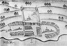
In 1520, the Portuguese established a trading post in the village of Lamakera on the eastern side of the island as a transit harbor between Maluku and Portuguese Malacca. In 1562, Dominican priests built a palm-trunk fortress which Javanese Muslims burned down the following year. The fort was rebuilt from more durable materials and the Dominicans commenced the Christianisation of the local population. By 1590 the Portuguese and Christian population numbered about 25,000. There were, however, repeated displays of resistance against both the Portuguese and their religion; in 1598-1599, for example, the Portuguese required an armada of 90 ships to put down a Solorese uprising.[2]
At this time, there was a conflict between the traders and the priests, so the traders left Solor and settled in Larantuka at Flores island. When the Dutch came in 1613, the priests surrendered at the first attack and were brought to Larantuka, too.
The Dutch kept the fort, but did not make a profit close to the Portuguese port. After two commanders defected to the Portuguese, they gave up Solor. In 1636 the Portuguese were attacked by the Dutch and had to abandon the fort. In 1646 the Dutch occupied the fort again. The first of the new commanders was suspended, because he married an indigenous woman. The second commander challenged the Portuguese commander to a duel and was slain. In 1648 the Dutch left and the Dominican priests returned.[3]
Towns and villages
- Aplame
- Balawelin
- Kelike
- Kukuwerang
- Lamakera, Indonesia
- Lamawolo
- Lewograran
- Liko
- Pamakayo
- Balawelin I - Riangtaliha and Lamalewo
- Balawelin II - Riangmuda and Rianglaka
- Daniwato
- Enatukan
- Sulengwaseng
- Kenere
- Lemanu
- Kelike - Lewolo and lamagohan
- Karawatung
- Ongalereng
- Menanga
- Liwo
- Lebao
- Lamboleng
- Apelame
- Buwu-Atagamu
- Lewograran
- Lewohedo
- Amakebo
- Wulublolong
- Lohayong
References
- ↑ Monk, K.A.; Fretes, Y.; Reksodiharjo-Lilley, G. (1996). The Ecology of Nusa Tenggara and Maluku. Hong Kong: Periplus Editions Ltd. p. 8. ISBN 962-593-076-0.
- ↑ Ricklefs, M.C. (1991). A History of Modern Indonesia Since c.1300, 2nd Edition. London: MacMillan. p. 25. ISBN 0-333-57689-6.
- ↑ Daus, Ronald (1983). Die Erfindung des Kolonialismus. Wuppertal: Hammer. pp. 325–327. ISBN 3-87294-202-6.
External links
Coordinates: 8°29′18″S 122°58′26″E / 8.48833°S 122.97389°E