North Maluku
| North Maluku Maluku Utara | |||
|---|---|---|---|
| Province | |||
   | |||
| |||
|
Motto(s): Marimoi Ngone Futuru (Ternate language: United we are strong) | |||
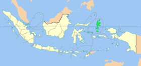 North Maluku as a part of the Maluku Islands | |||
| Coordinates: 0°47′N 127°22′E / 0.783°N 127.367°ECoordinates: 0°47′N 127°22′E / 0.783°N 127.367°E | |||
| Country |
| ||
| Capital | Sofifi | ||
| Largest city |
| ||
| Government | |||
| • Governor | Abdul Ghani Kasuba (PKS) | ||
| • Vice Governor | Muhammad Natsir Thaib | ||
| Area | |||
| • Total | 31,982.50 km2 (12,348.51 sq mi) | ||
| Population (2014)[1] | |||
| • Total | 1,141,561 | ||
| • Density | 36/km2 (92/sq mi) | ||
| Demographics | |||
| • Religion | Islam (74.28%), Protestantism (24.9%), Roman Catholicism (0.52%) | ||
| • Languages | Indonesian, Ternate | ||
| Time zone | WIT (UTC+9) | ||
| Vehicle registration | DG | ||
| HDI |
| ||
| HDI rank | 27th (2015) | ||
| Website |
www | ||
.png)

North Maluku (Indonesian: Maluku Utara) is a province of Indonesia. It covers the northern part of the Maluku Islands. The provincial capital is Sofifi, on Halmahera, and the largest population center is the island of Ternate.
The Maluku Islands was formerly administered as a single province, however, in 1999 it was split into two provinces, with North Maluku being created out of the northern section of the province of Maluku.
History
In the sixteenth and seventeenth century, the islands of North Maluku were the original "Spice Islands". At the time, the region was the sole source of cloves. The Dutch, Portuguese, Spanish, and local sultanates including Ternate and Tidore fought each other for control of the lucrative trade in these spices. Clove trees have since been transported and replanted all around the world, and the demand for cloves from the original spice islands has ceased, greatly reducing North Maluku's international importance.
The population of North Maluku was 1,038,087 at the 2010 Census[1] making it one of the least-populous provinces in Indonesia; at the latest estimate (January 2014) the population had risen to 1,141,561.
Geography
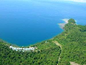
The islands of North Maluku are mostly of volcanic origin, with the volcanoes of Dukono on Halmahera, Gamalama on Ternate still active and the whole of Tidore consisting of a large stratovolcano. The rainforests of Halmahera, Morotai, the Obi Islands, the Bacan islands and other islands of North Maluku have been described by the World Wildlife Fund as the "Halmahera rain forests" ecoregion and are home to a number of plant and animal species unique to the islands, which are in the Wallacea transition zone, containing a mixture of species of Asian and Australasian origin. The predominant trees of the forest are Anisoptera thurifera, Hopea gregaria, Hopea iriana, Shorea assamica, Shorea montigena, Shorea selanica, and Vatica rassak.
The endemic mammals found here include the Obi mosaic-tailed rat (Melomys obiensis), masked flying fox (Pteropus personatus), and three arboreal marsupials, the ornate (Phalanger ornatus), Rothschild's (P. rothschildi), blue-eyed (P. matabiru) and Gebe (P. alexandrae) cuscuses. There are over two hundred different birds on the islands, twenty-six of which are endemic, a large number for this small island group. The endemics include four birds which are the only species in their genera, including the elusive invisible rail (Habroptila wallacii), the white-streaked friarbird (Melitograis gilolensis), and two birds of paradise, the paradise-crow (Lycocorax pyrrhopterus) and Wallace's standardwing (Semioptera wallacii). The islands are also home to the largest bee in the world, Wallace's giant bee (Megachile pluto).[2]
The islands have a tropical rainforest climate.
Most of the natural forest remains on these mountainous islands, although much of the coastal and lowland areas have been cleared for clove-planting since the sixteenth century, especially on the islands of Ternate and Tidore. Logging has occurred more recently on Halmahera and Morotai.
Administrative divisions
North Maluku Province was subdivided into seven regencies and two autonomous cities, listed below with their areas and their populations at the 2010 Census and at the latest (2014) Estimates. An eighth regency, covering Taliabu Island, was formed in 2013 from the westernmost island in the Sula Islands Residency.
| Name | Area (km2) | Population 2010 Census | Population 2014 Estimate | Capital | HDI[3] 2014 Estimates |
|---|---|---|---|---|---|
| Ternate (city) | 111.39 | 185,705 | 204,215 | - | 0.771 (High) |
| Tidore (city) | 1,645.73 | 90,055 | 99,031 | - | 0.667 (Medium) |
| Central Halmahera Regency (Halmahera Tengah) | 2,653.76 | 42,815 | 47,083 | Weda | 0.614 (Medium) |
| East Halmahera Regency (Halmahera Timur) | 6,571.37 | 73,109 | 80,396 | Maba | 0.632 (Medium) |
| Morotai Island Regency (Pulau Morotai) | 2,476.00 | 52,697 | 57,950 | Daruba | 0.583 (Low) |
| North Halmahera Regency (Halmahera Utara) | 3,896.90 | 161,847 | 177,980 | Tobelo | 0.641 (Medium) |
| South Halmahera Regency (Halmahera Selatan) | 8,148.90 | 198,911 | 218,738 | Labuha | 0.603 (Medium) |
| Sula Islands Regency (Kepulauan Sula) | 4,774.25 | 132,524 | 145,734 | Sanana | 0.601 (Medium) |
| Taliabu Island Regency (Pulau Taliabu) | # | # | # | Bobong | 0.573 (Low) |
| West Halmahera Regency (Halmahera Barat) | 1,704.20 | 100,424 | 110,434 | Jailolo | 0.620 (Medium) |
| Total Province | 31,982.50 | 1,038,087 | 1,141,561 | 0.651 (Medium) |
- # The figures for the new Taliabu Island Regency (created in 2013) are included in those for Sula Islands Regency.
Sultanates
The northern part of the Maluku Islands is the location of four major sultanates, locally known as Maluku kie raha (Ternate language: "Four Moluccan mountains"). While they no longer hold official or political power, these sultanates still hold enormous cultural respect.
- Sultanate of Ternate
- Sultanate of Tidore
- Bacan Sultanate
- Jailolo Sultanate
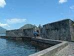
Fortresses
North Maluku has many fortresses:[4][5]
- Tolukko Fortress, is located 3 kilometers (2 miles) from Central Ternate, built by Portuguese in 1540 and renovated in 1610 by Dutch. The construction consists of sea-rock, sand, stone and egg as the adhesive.
- Kotanaka Fortress
- Orange Fortress
- Kalamata Fortress
- Dever Lacting Fortress
- Bernaveld Fortress
Economy
In the 2010s, efforts were undertaken to further develop the province. Governor Abdul Ghani Kasuba designated South Halmahera as a tourism region for the province,[6] inaugurating the Widi International Fishing Tournament for that purpose.[7] Kasuba also successfully negotiated with the China-based Jinchun Group to build a nine-trillion rupiah smelter in the Obi Islands.[8]
Demographics
Religion
See also
References
- 1 2 Central Bureau of Statistics: Census 2010 Archived 2010-11-13 at the Wayback Machine., retrieved 17 January 2011 (in Indonesian)
- ↑ "Halmahera Rain Forests". Terrestrial Ecoregions. World Wildlife Fund.
- ↑ Indeks-Pembangunan-Manusia-2014
- ↑ "Benteng Tolukko Buah Karya Nenek Moyang". September 10, 2012.
- ↑ "Wonderful Indonesia - Memorial Museum of the Sultanate of Ternate". Indonesia.travel. 1970-01-01. Archived from the original on 2016-04-07. Retrieved 2016-05-01.
- ↑ Widi Islands to be the Future of North Maluku Tourism. Tempo, 21 May 2017. Accessed 18 September 2017.
- ↑ Aria Cindyara, N Maluku to boost maritime sector through fishing tourism. Antara, 24 August 2017. Accessed 30 August 2017.
- ↑ China`s Jinchun to in vest Rp9 trillion in North Maluku. Antara, 16 July 2016. Accessed 18 September 2017.
- ↑ "Population by Region and Religion in Indonesia". BPS. 2010.
Regencies and cities of North Maluku | ||
|---|---|---|
Capital: Sofifi | ||
| Regencies | ||
| Cities | ||
Capital: Jakarta | ||
| Sumatra |  | |
| Java | ||
| Kalimantan | ||
| Lesser Sunda | ||
| Sulawesi | ||
| Maluku | ||
| Papua | ||
| Former | ||
Lists by
| ||