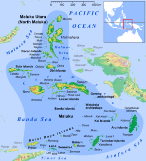
Gorong archipelago
 Gorong archipelago in the east of Maluku Islands | |
| Geography | |
|---|---|
| Location | South East Asia |
| Coordinates | 4°01′22″S 131°25′01″E / 4.02278°S 131.41694°E |
| Total islands | 3 |
| Major islands | Gorom, Panjang and Manawoka |
| Administration | |
|
Indonesia | |
| Provinces | Maluku |
| Demographics | |
| Population | 27285 (2010) |
| Ethnic groups | Melanesian |
Gorong archipelago is a group of islands between Watubela archipelago and Ceram in the Maluku Islands.
History
The Nagarakretagama, an Old Javanese eulogy to king Hayam Wuruk of Majapahit written in 1365, mentions "Gurun" amongst the tributary countries of the kingdom.[1]
The English naturalist Alfred Russel Wallace described the islands, which he called Goram, in chapter 25 of his 1869 book The Malay Archipelago.[2]
Islands
The archipelago has three islands.[3]
- Gorom, the biggest island, with the villages of Miran (Miren) on the east coast, Ondor (Ondur) in the northwest and Hur on its southwestern coast.
- Panjang to the west of Gorong, with Wisalem village in its southern end.
- Manawoka in the south, with the villages of Arbau in the north, Amar and Derra, and Nama in the south.
References
- ↑ Denys Lombard, Le carrefour javanais (1990)
- ↑ Wallace, Alfred Russel (1869). "25: Ceram, Goram, and the Matabello Islands". The Malay Archipelago: The land of the orang-utan, and the bird of paradise. A narrative of travel, with sketches of man and nature (1 ed.). Macmillan.
- ↑ Government of Indonesia Seram Bagian Timur map
This article is issued from
Wikipedia.
The text is licensed under Creative Commons - Attribution - Sharealike.
Additional terms may apply for the media files.