Lampung
| Lampung | |||
|---|---|---|---|
| Province | |||
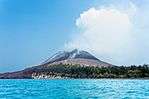 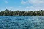  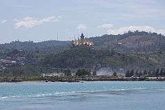 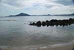  Clockwise, from top left : View of Lampung Bay, Pahawang Islands, Bakauheni Port and Siger Tower, Bandar Lampung, Klara Beach, Bukit Barisan Selatan National Park, Mount Anak Krakatau | |||
| |||
| Motto(s): Sai Bumi Ruwa Jurai ("Two Peoples, One Land") | |||
 Location of Lampung in Indonesia | |||
| Coordinates: 5°27′S 105°16′E / 5.450°S 105.267°ECoordinates: 5°27′S 105°16′E / 5.450°S 105.267°E | |||
| Country |
| ||
| Capital |
| ||
| Established | 18 March 1964 | ||
| Government | |||
| • Body | Lampung Regional Government | ||
| • Governor | Muhammad Ridho Ficardo (Democratic) | ||
| • Vice Governor | Bachtiar Basri | ||
| Area | |||
| • Total | 35,376 km2 (13,659 sq mi) | ||
| Area rank | 22nd | ||
| Highest elevation | 2,262 m (7,421 ft) | ||
| Population (2017)[1][2] | |||
| • Total | 8,289,000 | ||
| • Rank | 8th | ||
| • Density | 230/km2 (610/sq mi) | ||
| Demonym(s) |
Lampungese Warga Lampung (id) | ||
| Demographics | |||
| • Ethnic groups | Javanese (62%), Sundanese (9%), Lampung (25%), Malay (4%), Bantenese (3%)[3] | ||
| • Religion | Muslim (92%), Protestant (1.8%), Catholic (0.8%), Hinduism (1.7%), Buddhist (0.3%) | ||
| • Languages |
Indonesian (official) Lampung (lingua franca) Lampung Nyo (dialect o) Lampung Api (dialect a) Javanese Komering Sundanese | ||
| Time zone | UTC+7 (Indonesia Western Time) | ||
| Postcodes | 30xxx, 31xxx, 32xxx | ||
| Area codes | (62)7xx | ||
| ISO 3166 code | ID-LA | ||
| Vehicle registration | BE | ||
| HDI |
| ||
| HDI rank | 24th (2014) | ||
| Largest city by area | Bandar Lampung – 118.50 square kilometres (45.75 sq mi) | ||
| Largest city by population | Bandar Lampung – (1,166,761 – 2015) | ||
| Largest regency by area | Tulang Bawang Regency – 6,851.32 square kilometres (2,645.31 sq mi) | ||
| Largest regency by population | Central Lampung Regency – (1,170,048 – 2015) | ||
| Website | Government official site | ||
Lampung is a province in Indonesia. It is located in the southern tip of the island of Sumatra and borders the provinces of Bengkulu and South Sumatra to its north. It is the original home of the Lampung people, who speak their own language and possess their own written script. Its capital is Bandar Lampung.
As of January 2014, the province has a population of 7,972,246. Three-quarters of the current population of Lampung are descendants of Javanese, Madurese, and Balinese migrants. These migrants came from more densely populated islands, in search of available land, as well as part of the national government's transmigration program, for which Lampung was one of the earliest and most significant transmigration destinations.
Lampung is geologically unstabile. On 10 May 2005, a 6.4 magnitude earthquake struck the province. The historic volcanic eruption of Krakatau in 1883 had disastrous consequences for the area.
| Historical population | ||
|---|---|---|
| Year | Pop. | ±% |
| 1971 | 2,777,008 | — |
| 1980 | 4,624,785 | +66.5% |
| 1990 | 6,017,573 | +30.1% |
| 1995 | 6,657,759 | +10.6% |
| 2000 | 6,741,439 | +1.3% |
| 2010 | 7,596,115 | +12.7% |
| 2014 | 7,972,246 | +5.0% |
| 2017 | 8,289,000 | +4.0% |
| Source: Badan Pusat Statistik 2017 | ||
History
In the 7th century, word spread throughout China, of a region located in the far south (Namphang) known as "Tolang Pohwang". "To" meaning 'people' in Lampungese while "Lang Pohwang" was the then-popular name for the region that is now Lampung. It is possible that Lampung was part of the Kingdom of Srivijaya, with its regional capital in Jambi, which controlled most parts of Southeast Asia up until the 11th century. The Srivijayans came to Lampung in search of gold and amber, two of the province's natural resources.
This history is substantiated by both unearthed relics and the discovery of the Palas Pasemah inscriptions and the Batu Bedil inscriptions in the Tenggamus region that trace back to Srivijayan times and civilization. Other, smaller kingdoms like Tulang Bawang (name still extant as a regency in the province) and Skala Brak also existed during the 7th to 8th centuries CE. The former was centered around the Tulang Bawang River, hence the name.
The entry of the Banten Sultanate in Lampung in the 16th century marked the beginning of the spread of Islam in the region. Lampung is known for pepper which at that time was in high demand. At that time, the Dutch began pressing for control of the region.[4] In the 1930s Lampung still accounted for 30% of world pepper production.[5]
The control of pepper production exercised by the Banten Sultanate made Lampung one of the most prosperous harbors in the archipelago. Similarly, pepper plants also attracted migrants from Europe as employees of trading companies. It was in 1610 that the Dutch East India Company established a trading post in Banten and later in 17th century began the forceful pepper cultivation in Lampung in order to increase its already existing production.[6] The area was part of the Banten Sultanate until it was annexed by the Dutch in 1752, when it became known as the Residentie Lampoengse Districten.[7] It became part of the Dutch East Indies.
Under the Dutch rule, transmigration programs were implemented. This program involved the migration of people from Java to Lampung. This program was quite well-received and many residents of Java moved to the transmigration sites located in the eastern region of Lampung. The program was expanded after Indonesian independence in the 1960s. Natives of Java brought cultural devices to Lampung, such as the gamelan and wayang. Islanders of Bali then also came to Lampung to follow the transmigration program. The presence of migrants from other regions in Lampung has made this region culturally diverse. Ethnic diversity has become a tourist attraction in itself, with the added potential of nature and cultural tourism. The many art studios in the area act as a preserver of indigenous art and culture.
Geography
Lampung Province has an area of 35,376.50 km2 (13,658.94 sq mi) and is located between the latitudes of 105°45'-103°48 'E and 3°45'-6°45'S. The province borders the Sunda Strait to the southeast and the Java Sea to the east. There are islands within Lampung Province, such as Daro, Legundi, Tegal, Sebuku, Ketagian, Sebesi, Poahawang, Krakatoa, Putus, and Tabuan. These islands are located mostly in the Bay of Lampung. Pisang Island lies at the entrance to the regency of West Lampung.
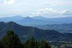
Lampung's natural terrain varies depending on the region. Along the coast in the west and the south is an area of rolling hills connected to the Bukit Barisan range, running throughout Sumatra from north to south. In the center of the province is mostly lowland. Close to the coast in the east, along the shores of the Java Sea, further north, is the great waters.
The mountains that are situated in Lampung by height include:
- Mount Pesagi (2,262 m [7,421 ft]) in Liwa, West Lampung
- Mount Seminung (1,881 m [6,171 ft]) in Sukau, West Lampung
- Mount Tebak (2,115 m [6,939 ft]) in Sumberjaya, West Lampung
- Mount Rindingan (1,506 m [4,941 ft]) on the island stage, Tanggamus
- Mount Pesawaran (1,662 m [5,453 ft]) in Kedondong, Pesawaran
- Mount Betung (1,240 m [4,070 ft]) in Teluk Betung, Bandar Lampung
- Mount Rajabasa (1,261 m [4,137 ft]) at the Trump, South Lampung
- Mount Tanggamus (2,156 m [7,073 ft]) in Kotaagung, Tanggamus
- Mount Krakatau in the Sunda Strait, South Lampung
- Mount Sekincau Liwa, West Lampung
- Mount Ratai in Padang Cermin, Pesawaran
The rivers that flow in Lampung by length and catchment area (CA) are:
- Way Sekampung, length 265 km (165 mi), CA 4,795.52 km2 (1,851.56 sq mi)
- Way Semaka, length of 90 km (56 mi), CA 985 km2 (380 sq mi)
- Way Seputih, length 190 km (120 mi), CA 7,149.26 km2 (2,760.34 sq mi)
- Way Jepara, 50 km (31 mi), CA 1,285 km2 (496 sq mi)
- Way Tulangbawang, length 136 km (85 mi), CA 1,285 km2 (496 sq mi)
- Way Mesuji, length 220 km (140 mi), CA 2,053 km2 (793 sq mi)
- Way Sekampung, flowing in the district Tanggamus, Pringsewu, Pesawaran and South Lampung. Many tributaries, but no longer than 100 km (62 mi). There is only one long river 51 km (32 mi) to CA 106.97 km2 (41.30 sq mi) is in the Trump Way Ketibung.
- Way Putih flows in Central Lampung regency with tributaries that are longer than 50 km (31 mi) are:
- Way Terusan, 175 km (109 mi) long, CA 1,500 km2 (580 sq mi)
- Way Pengubuan, length 165 km (103 mi), CA 1,143.78 km2 (441.62 sq mi)
- Way Pegadungan, a length of 80 km (50 mi), CA 975 km2 (376 sq mi)
- Way Raman, length 55 km (34 mi), CA 200 km2 (77 sq mi)
- Way Tulangbawang flows in the district Tulangbawang with creeks more than 50 km (31 mi) in length, of which:
- Way Kanan, length 51 km (32 mi), CA 1,197 km2 (462 sq mi)
- Way Rarem, length 53.50 km (33.24 mi), CA 870 km2 (340 sq mi)
- Way Umpu, a length of 100 km (62 mi), CA 1,179 km2 (455 sq mi)
- Way Tahmy, a length of 60 km (37 mi), CA 550 km2 (210 sq mi)
- Way Besay also supplies a length of 113 km (70 mi), CA 879 km2 (339 sq mi)
- Way Giham, a length of 80 km (50 mi), CA 506.25 km2 (195.46 sq mi)
- Way Mesuji flows on the border of the provinces of Lampung and South Sumatra and to the north has a tributary named Crocodile River, along the 70 km (43 mi) by CA 347.5 km2 (134.2 sq mi).
Forests in the lowlands have been exhausted after being appropriated for agricultural development, which is needed for the migrants constantly entering this area. Timber forest products are exported abroad. Some forests remain in the area of Bukit Barisan Selatan.
Cities in the province of Lampung with a height of 50 meters over sea level are: Tandjungkarang (96 m [315 ft]), Kedaton (100 m [330 ft]), Metro (53 m [174 ft]), Gisting (480 m [1,570 ft]), State Sakti (100 m [330 ft]), Pringsewu (50 m [160 ft]), Pekalongan (50 m [160 ft]), Batang (65 m [213 ft]), Punggur (50 m [160 ft]), Padang Queen (56 m [184 ft]), Wonosobo (50 m [160 ft]), Kedondong (80 m [260 ft]), Sidomulyo (75 m [246 ft]), Kasui (200 m [660 ft]), Sri Menanti (320 m [1,050 ft]) and Liwa (850 m [2,790 ft]).
Administrative divisions
Lampung Province is subdivided into twelve regencies (kabupaten) and two autonomous cities (kota), listed below with their areas and their populations at the 2010 Census and at the most recent (January 2014) estimates. A thirteenth regency – West Pesisir Regency – was formed on 25 October 2012 from part of the West Lampung Regency, but no separate statistics are yet available.
| Name | Area (km2) | Population Census 2010 | Population Estimate 2014 | Capital | HDI 2014 Estimates |
|---|---|---|---|---|---|
| Bandar Lampung City | 118.50 | 879,651 | 923,970 | Bandar Lampung | 0.743 (High) |
| Metro City | 68.74 | 145,346 | 152,428 | Metro | 0.749 (High) |
| Central Lampung Regency (Lampung Tengah) | 4,789.80 | 1,170,048 | 1,226,702 | Gunung Sugih | 0.670 (Medium) |
| East Lampung Regency (Lampung Timur) | 5,325.03 | 950,574 | 997,147 | Sukadana | 0.664 (Medium) |
| Mesuji Regency | 432.60 | 187,286 | 196,369 | Mesuji | 0.587 (Low) |
| North Lampung Regency (Lampung Utara) | 2,725.63 | 583,925 | 612,218 | Kotabumi | 0.648 (Medium) |
| Pesawaran Regency | 2,243.51 | 397,294 | 417,921 | Gedong Tataan | 0.617 (Medium) |
| Pringsewu Regency | 625.00 | 364,825 | 382,841 | Pringsewu | 0.665 (Medium) |
| South Lampung Regency (Lampung Selatan) | 2,109.74 | 909,989 | 956,126 | Kalianda | 0.637 (Medium) |
| Tanggamus Regency | 3,356.61 | 534,595 | 562,274 | Kota Agung | 0.626 (Medium) |
| Tulang Bawang Regency | 6,851.32 | 397,079 | 416,934 | Menggala | 0.658 (Medium) |
| Way Kanan Regency | 3,921.63 | 406,735 | 425,544 | Blambangan Umpu | 0.643 (Medium) |
| West Lampung Regency (Lampung Barat) | 4,950.40 | 418,560 | 439,076 | Liwa | 0.635 (Medium) |
| West Pesisir Regency (Pesisir Barat) | 2,907.23 | * | 163,321 | Krui | 0.597 (Low) |
| West Tulang Bawang Regency (Tulang Bawang Barat) | 1,201.00 | 250,208 | 262,696 | Panaragan Jaya | 0.624 (Medium) |
| Total Province | 34,623.80 | 7,596,115 | 7,972,246 | Bandar Lampung | 0.664 (Medium) |
- Note
* – The area and population for West Pesisir Regency are included in the figures for West Lampung Residency given above.
Agriculture
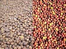
Major crops in the region include robusta coffee beans, cocoa beans, coconuts and cloves. This has resulted in a thriving agricultural sector with companies like Nestlé procuring coffee beans from the region. This agriculture has included illegal growing in Bukit Barisan Selatan National Park.[8] In addition, nata de coco is also manufactured in the region by domestic companies like Wong Coco.
Textiles
_in_adatkostuum_TMnr_10002793.jpg)
Up until the 1920s, Lampung had a rich and varied weaving tradition. Lampung weaving used a supplementary weft technique which enabled coloured silk or cotton threads to be superimposed on a plainer cotton background. The most prominent Lampung textile was the Palepai, ownership of which was restricted to the Lampung aristocracy of the Kalianda Bay area.[9] There were two types of smaller clothes, known as tatibin and tampan, which could be owned and used by all levels of Lampungese society. Weaving technologies were spread throughout Lampung. High-quality weavings were produced by the Paminggir, Krui, Abung and Pesisir peoples. Production was particularly prolific among the people of the Kalianda Bay area in the south and the Krui aristocracy in the north.
Lampung textiles, Palepai, tatebin and tampan were called 'ship cloths' because ships are a common motif.[10] The ship motif represents the transition from one realm of life to the next, for instance from boyhood to manhood or from being single to married and also represents the final transition to the afterlife.[9]
Traditionally, Lampung textiles were used as part of religious ceremonies such as weddings and circumcisions. For instance, Palepai cloths were used as long ceremonial wall-hangings behind the bridal party in aristocratic marriages. The smaller, more humble tampan cloth were exchanged between families at the time of weddings.
Production of fine cloth blossomed in the late nineteenth century as Lampung grew rich on pepper production, but the devastating eruption of Krakatoa in 1883 destroyed many weaving villages in the Kalianda area.[11] By the 1920s the increasing importance of Islam and the collapse of the pepper trade brought production to a halt.[12] Today Lampung textiles are highly prized by collectors.
Tourism
Although tourism is not Lampung Province's main source of income, the administration has attempted to boost tourism through Flamboyant Tanjung Setia. This event seeks to draw tourists to Tanjung Setia Beach, which has a natural panoramic view and challenging waves for surfing. Another tourist attraction is the Way Kambas National Park, which is popular with local tourists. In 2010, four-hundred thousand tourists visited Lampung Province, including ten thousand foreign tourists mainly from Australia and New Zealand.[13]
Way Kambas National Park is a national park and elephant sanctuary in the district of Labuhan Ratu, East Lampung, Indonesia. In addition to Way Kambas, another elephant school (Elephant Training Centre) can also be found in Minas, Riau. The number of Sumatran elephants (Elephas maximus sumatranus) living in the region has decreased. Way Kambas National Park was established in 1985 as the first elephant school in Indonesia and is expected to become a center for elephant conservation in taming, training, breeding and conservation. Until now, this PKG has trained about three hundred elephants that have been deployed to other parts of the country.
In recent years, the province has been largely popular for snorkeling and diving. Many domestic tourists, as well as international ones from various diving communities, have been visiting the different spots the province offers, such as Pantai Ringgung, Pulau Tegal, Pulau Pahawang, Pulau Kelagian, Pulau Balak, Pulau Mahitam, and Tanjung Putus.
Demographics
Lampung is a multi-ethnic province with three major ethnic groups, namely Javanese, Lampungese and Sundanese, where Lampungese are the native ethnicity in the province. The pluralistic society of Lampung uses various languages, including Indonesian, Javanese, Sundanese, Balinese, Minangkabau and Lampung.
Transport
Land
There is no highway in the province of Lampung, but the Bakauheni-Bandar Lampung-Terbanggi Besar tollway has been under construction since April 2015. The tollway will span from Bakauheni in South Lampung to Terbanggi Besar in Central Lampung along 139 kilometres (86 mi). It is planned to be fully operational in 2019.[15]
The regional toll roads Bakauheni-Terbanggi Besar are expected to be completed in four years with funding from the private sector, government, private and government combined. As for the cost of development, is predicted to reach Rp 53 trillion, including land acquisition and construction of approximately Rp 30 trillion.[16] Lampung has a bus terminal at Terminal Rajabasa which is one of the biggest and busiest in Sumatra and Lampung, as well as the Talbot terminal in Bandar Lampung. Rajabasa airport's terminal at close range, intermediate, and far (AKAP) which has bus routes to cities in Sumatra and Java. .
In addition to these two terminals, there are bus terminals located throughout the capital district in Lampung.
Sea
In the province, there are several ports. The Port of Panjang is an import-export harbor and Port Srengsem which serves the traffic coal distribution from South Sumatra to Java. About 92 kilometres (57 mi) south of Bandar Lampung, lies the port city of Bakauheni, precisely at the southern tip of Sumatra. Located at the southern end of the Trans-Sumatran Highway, the Bakauheni port connects Sumatra to the Port of Merak in Java via sea transportation.
Air
Radin Inten II Airport is the only airport in the province. It serves flights to Jakarta, Medan, Bandung, Palembang, and more.
Rail
Lampung Province has a railway line between Bandar Lampung - Palembang, which is part of a railway network in South Sumatra operated by PT Kereta Api (Persero) Divre IV Tanjung Karang, located in Bandar Lampung. Bandar Lampung - Palembang railway line holds forty stations along 387,872 km (241,012 mi) stretches between Tanjungkarang Station in Bandar Lampung to Kertapati Station in Palembang.
See also
References
- ↑ "Statistik Indonesia 2018". Badan Pusat Statistik. Retrieved July 23, 2018.
- ↑ Central Bureau of Statistics: Census 2010 Archived 13 November 2010 at the Wayback Machine., retrieved 17 January 2011 (in Indonesian)
- ↑ Indonesia's Population: Ethnicity and Religion in a Changing Political Landscape. Institute of Southeast Asian Studies. 2003.
- ↑ Changes of Regime And Social Dynamics in West Java: Society, State And the Outer World of Banten, 1750-1830
- ↑ https://openaccess.leidenuniv.nl/bitstream/handle/1887/16242/06.pdf?sequence=12
- ↑ Southeast Asia: A Historical Encyclopedia, from Angkor Wat to East Timor, Volume 1
- ↑ "Lampung Arms". Retrieved 24 July 2016.
- ↑ Claire Leow. Nestlé to scrutinize Indonesia coffee amid wildlife-endangerment fears, International Herald Tribune.
- 1 2 "Ceremonial Hanging (palepai)". Pacific Islands art. Dallas Museum of Art. Archived from the original on 4 October 2006. Retrieved 26 September 2007.
- ↑ Gittinger, M. Splendid Symbols, Textiles and Tradition in Indonesia. Textile Museum, Washington D.C. 1979.Library of Congress No 79-50373 p.88
- ↑ Gittinger, Mattiebelle S, SOUTH SUMATRAN SHIP CLOTHS. 1979 www.cs.arizona.edu/patterns/.../nb74_shp.pdf p.15
- ↑ Sudha Rajagopalan; Navigating Culture: Trade and Transformation in the Island State. The Permanent Exhibition on Indonesia. Museum Volkenkunde, Leiden.
- ↑ "Waspada Online – Pusat Berita dan Informasi Medan Sumut Aceh". Waspada.co.id. Retrieved 2016-07-24.
- ↑ "Population by Region and Religion in Indonesia". BPS. 2010.
- ↑ Presiden Jokowi Hari ini Akan Lakukan Groundbreaking Jalan Tol Bakauheni
- ↑ Pemerintah bangun tol Bakauheni Terbanggi Besar di 2015
Further reading
- Elmhirst, R. (2001). Resource Struggles and the Politics of Place in North Lampung, Indonesia. Singapore Journal of Tropical Geography. 22(3):284–307.
- Pain, Marc (ed). (1989). Transmigration and spontaneous migrations in Indonesia: Propinsi Lampung. Bondy, France: ORSTOM.
External links
- Early Indonesian textiles from three island cultures: Sumba, Toraja, Lampung, an exhibition catalogue from The Metropolitan Museum of Art Libraries (fully available online as PDF), which contains material on Lampung
Regencies and cities of Lampung | ||
|---|---|---|
Capital: Bandar Lampung | ||
| Regencies | ||
| Cities | ||
Capital: Jakarta | ||
| Sumatra |  | |
| Java | ||
| Kalimantan | ||
| Lesser Sunda | ||
| Sulawesi | ||
| Maluku | ||
| Papua | ||
| Former | ||
Lists by
| ||