Togian Islands
| Native name: Kepulauan Togean | |
|---|---|
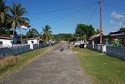 Togian Village | |
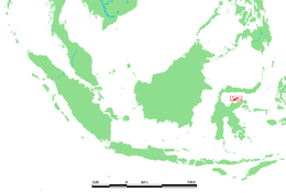 Map showing the Togian Islands highlighted in red. | |
| Geography | |
| Location | South-east Asia |
| Total islands | 56 |
| Major islands | Batudaka, Talatakoh, Togian |
| Administration | |
| Province | Central Sulawesi |
| Demographics | |
| Ethnic groups | Bajau |
| Additional information | |
| Time zone | |

The Togian (or Togean) Islands are an archipelago of 56 islands and islets, in the Gulf of Tomini, off the coast of Central Sulawesi, in Indonesia. The three largest islands are Batudaka, Togean, and Talakatoh. There are 37 villages on the islands, with one settled by the Bajau people, more commonly known as the sea gypsies.[1]
Administration
The islands are a part of the Tojo Una-Una Regency within Central Sulawesi Province. They comprise four districts [kabupaten in Indonesian) within that regency.
| Name | Area in sq.km | Population Census 2010 |
|---|---|---|
| Una-Una | 352.72 | 12,437 |
| Togean | 161.88 | 9,099 |
| Walea Kepulauan (Walea Islands) | 157.34 | 10,293 |
| Walea Besar (Great Walea) | 82.38 | 3,847 |
| Total Togean Islands | 754.32 | 35,676 |
Geology and ecology
Formed by volcanic activity, the islands are covered by rainforest and surrounded by coral reef formations, which provide habitat and breeding areas for hawksbill turtle, green turtle and the dugong. The Tonkean macaque is found in the islands' forests. The Togian hawk-owl, discovered in 1999, is endemic to the islands. The Togian white-eye, another endemic bird species, was described in 2008. Non-venomous jellyfish are also found in Togian Islands, the unique one is jellyfish with red little spots.[2]
National Park
On 2004, the government established a part of Togean Islands as a National Park consists of 292,000 hectares of sea water (includes 132,000 hectares of coral reef which is the largest in Indonesia), 70,000 hectares of land and 10,659 hectares reservation of forests and mangroves.[3]
See also
References
- ↑ Most unique destination in Indonesia - The Togean Islands
- ↑ "Tujuh Danau Ubur-Ubur Unik di Indonesia". Retrieved November 5, 2014.
- ↑ "Keindahan Bawah Luat Terpendam di Kepulauan Togean". September 25, 2011.
External links

- Informative and rare trip report