West Papua (province)
| West Papua Papua Barat | |||
|---|---|---|---|
| Province | |||
.jpg) | |||
| |||
|
Motto(s): Cintaku Negeriku (Indonesian) (My love, my country) | |||
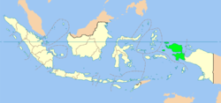 Location of West Papua | |||
| Coordinates (Manokwari): 0°52′S 134°5′E / 0.867°S 134.083°ECoordinates: 0°52′S 134°5′E / 0.867°S 134.083°E | |||
| Country |
| ||
| Capital | Manokwari | ||
| Largest city | Sorong | ||
| Government | |||
| • Governor | Dominggus Mandacan | ||
| • Vice Governor | Mohammad Lakotani | ||
| Area | |||
| • Total | 140,375.62 km2 (54,199.33 sq mi) | ||
| Area rank | 5th | ||
| Population (2014) | |||
| • Total | 877,437 | ||
| • Density | 6.3/km2 (16/sq mi) | ||
| Demographics | |||
| • Ethnic groups | Melanesian, Papuan (51.5%), Javanese (14.8%), Bugis (5.3%), Ambonese (4.4%), Butonese (4.1%), Makassar (2.3%), Kei (2.2%), Toraja (1.8%), Minahasa (1.8%), Seram (1.3%), Flores (1%), Sundanese (1%), Batak (1%), Ternate (0.9%), Chinese (0.3%), Gorontaloan (0.2%), Madurese (0.2%), Betawi (0.1%), Bantenese (0.1%), Lampung (0.1%), Balinese (0.1%), Sasak (0.1%), Dayak (0.1%), Minangkabau (0.1%), Foreign (0.1%), Others (Tobelo, ... etc.) (5.5%) | ||
| • Religion | Protestantism (53.77%), Islam (38.4%), Roman Catholicism (7.03%), Hinduism (0.11%), Buddhism (0.08%) | ||
| • Languages | Indonesian (official) | ||
| Time zone | UTC+09 (EIT) | ||
| Vehicle registration | PB | ||
| HDI |
| ||
| HDI rank | 33rd (2016) | ||
| Website | PapuaBaratProv.go.id | ||
.svg.png)
West Papua (Indonesian: Papua Barat) is a province of Indonesia. It covers the two western peninsulas of the island of New Guinea along with nearby islands. Its capital is Manokwari, although the largest city is Sorong, and the 2010 census recorded a population of 760,855; the latest official estimate (as at January 2014) is 877,437. Most of the province is in the Southern Hemisphere, with a few small northwestern islands such as Sajang Island in the Northern Hemisphere.
West Papua is also the name used by native Melanesians and NGOs to designate a territory which claimed its independence in 1961, and was subsequently annexed by Indonesia and integrated into it after a contested referendum of self-determination in 1969.[1][2] Since 2014, the official name of the political group that represents the Melanesian population of western New Guinea in the Melanesian Spearhead Group is the United Liberation Movement for West Papua (ULMWP).
In brief, Indonesian officials and administrators refer to the province when they say "West Papua"; while native Melanesians, independence activists and non-governmental organizations mean the whole of western New Guinea.[3]
West Papua (here understood as a province of Indonesia) was created from the western portion of Papua in February 2003, initially under the name of West Irian Jaya (Indonesian: Irian Jaya Barat); it received its current name in 2007. The province covers the Bird's Head (Doberai) and Bomberai peninsulas and the surrounding islands of Raja Ampat. With a population of 877,437 in 2014, it is the least populous province of Indonesia except for the newly created province of North Kalimantan.
History
Even after Indonesia's independence in 1945, West Papua (here understood as the western half of the island of New Guinea) was retained by the Dutch for various reasons. However, Indonesia claimed all of the territory of the former Dutch East Indies, including the Dutch New Guinea holdings. Indonesia repeatedly launched military operations against West Papua in 1961 and 1962, but these failed. It was agreed through the New York Agreement in 1962 that the administration of West Papua would be temporarily transferred from the Netherlands to Indonesia and that by 1969 the UN should oversee a referendum of the West Papuan people, in which they would be given two choices: to remain part of Indonesia or to become an independent nation. This vote was referred to as the 'Act of Free Choice'. However, the vote was in fact conducted by consensus decision-making, or consensus of elders, numbering slightly over 1,000. [lower-alpha 1] 1,000 of these men had been selected by the Indonesian military. This body was coerced at gunpoint into unanimously voting to remain part of Indonesia; the territory was named as the province of Irian Jaya, later Papua.
The result of the compromised vote was rejected by West Papuan nationalists, who established the Free Papua Movement (OPM). The independence movement for West Papua has continued, primarily through peaceful protest and international pressure, but also guerrilla warfare against the Indonesian administration.[7]

West Papua (the province) was created from the western portion of Papua province in February 2003, initially under the name of Irian Jaya Barat; it was later renamed Papua Barat (West Papua) on 7 February 2007. In November 2004, an Indonesian court agreed that the split violated Papua's autonomy laws. However, the court ruled that because the new province had already been created, it should remain separate from Papua. The ruling also prohibited the creation of another proposed province, Central Irian Jaya, as that division had not yet been formalised. The split is in line with the general trend of provincial splits that is occurring in all parts of Indonesia in the post-Suharto era. The province changed its name to "West Papua" on 7 February 2007. The new name applies from that date, but a plenary session of the provincial legislative council is required to legalise the change of name, and the government needs to issue an implementing regulation.[8]
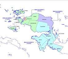
Administrative divisions
In 2000 the areas now forming (since 2003) West Papua province consisted of three regencies (kabupaten) – Manokwari, Sorong and Fakfak. By 2010 the province was administratively divided into ten regencies (kabupaten) and one autonomous city (kota), which together were subdivided into 155 districts (kecamatan) at the 2010 Census.[9] Two new regencies have since been created; all the existing regencies and city are listed below with their populations at the 2010 Census and according to the latest official estimates (for January 2014).
| Name | Area (km2) | Population Census 2010 | Population 2014 estimate | Capital | Number of Districts | HDI[10] 2014 estimate |
|---|---|---|---|---|---|---|
| Sorong (city) | 656.64 | 190,625 | 219,958 | Sorong | 6 | 0.757 (High) |
| Fakfak Regency | 11,036.48 | 66,828 | 77,112 | Fakfak | 9 | 0.647 (Medium) |
| Kaimana Regency | 16,241.84 | 46,249 | 53,366 | Kaimana | 7 | 0.610 (Medium) |
| Manokwari Regency | 11,674.76 | 187,726 | 216,614 | Manokwari | 29 | 0.693 (Medium) |
| Manokwari Selatan Regency (South Manokwari) | 2,812.44 | 18,564 | * | Ransiki | 0.553 (Low) | |
| Maybrat Regency | 5,461.69 | 33,081 | 38,067 | Kumurkek | 11 | 0.553 (Low) |
| Pegunungan Arfak Regency (Arfak Mountains) | 2,773.74 | 23,877 | * | Anggi | 0.536 (Low) | |
| Raja Ampat Regency | 8,034.44 | 42,507 | 49,048 | Waisai | 17 | 0.608 (Medium) |
| Sorong Regency | 7,415.29 | 70,619 | 81,486 | Aimas | 18 | 0.612 (Medium) |
| Sorong Selatan Regency (South Sorong) | 3,946.94 | 37,900 | 43,898 | Teminabuan | 14 | 0.582 (Low) |
| Tambrauw Regency[11] | 5,179.65 | 6,144 | 7,028 | Fef | 7 | 0.494 (Low) |
| Teluk Bintuni Regency (Bintuni Bay) | 20,840.83 | 52,422 | 60,489 | Bintuni | 24 | 0.604 (Medium) |
| Teluk Wondama Regency (Wondama Bay) | 3,959.53 | 26,321 | 30,371 | Rasiei | 13 | 0.562 (Low) |
- * The areas and 2014 population of Arfak Mountains and South Manokwari Regencies are included in the figures for Manokwari Regency, from which they were removed.
Subsequent to the 2010 Census, two new regencies – South Manokwari Regency (Manokwari Selatan) and Arfak Mountains Regency (Pegunungan Arfak) – were created from parts of the Manokwari Regency, while 4 districts of Manokwari Regency were added to Tambrauw Regency. The 2010 Census figures quoted above for all four of these regencies relate to their area as established in 2010.
On 25 October 2013 the Indonesian House of Representatives (DPR) began reviewing draft laws on the establishment of 57 prospective regencies/cities (and 8 new provinces).[12] This included a new province of Southwest Papua to be created out of the existing West Papua province, together with eight new regencies and one city to be formed within the existing West Papua Province – Malamoy and Maibratsau (both taken from Sorong Regency), North Raja Ampat and South Raja Ampat (both from Raja Ampat Regency), Raja Maskona (from Teluk Bintuni Regency), Okas (from Fakfak Regency), West Manokwari (from Manokwari Regency) and Imeo (from South Sorong Regency), while the new city is Manokwari (from Manokwari Regency).
Demographics
| Historical population | ||
|---|---|---|
| Year | Pop. | ±% |
| 1971 | 192,146 | — |
| 1980 | 283,493 | +47.5% |
| 1990 | 385,509 | +36.0% |
| 2000 | 571,107 | +48.1% |
| 2010 | 760,422 | +33.1% |
| Source: Statistics Indonesia 2010. West Papua part of Papua Province until 2004 | ||
Religion
See also
Notes
References
- ↑ Saltford, J. (2003). The United Nations and the Indonesian takeover of West Papua, 1962-1969: The anatomy of betrayal, 1st edn. Routledge, London.
- ↑ Cribb, R.B.; Kahin, Audrey (2004). Historical Dictionary of Indonesia. Scarecrow Press. p. 313.
- ↑ Ver Berkmoes, Ryan (2010). Indonesia. Lonely Planet. p. 775.
- ↑ Brad Simpson, ed. (9 July 2004). "Indonesia's 1969 Takeover of West Papua Not by "Free Choice"". National Security Archive. Retrieved 2013-01-17.
- ↑ "Breaking Free From Betrayal". New International. 5 November 1999. Retrieved 2013-01-17.
- ↑ Richard Samuelson. "About West Papua". International Parliamentarians for West Papua. Retrieved 2013-01-17.
- ↑ Li-ann Thio (2006), "International law and secession in the Asia and Pacific regions", in Marcelo G. Kohen, Secession: International Law Perspectives, Cambridge University Press
- ↑ "Papuan province changes name from West Irian Jaya to West Papua". Radio New Zealand International. 7 February 2007. Retrieved 27 December 2008.
- ↑ Biro Pusat Statistik, Jakarta, 2011.
- ↑ Indeks-Pembangunan-Manusia-2014
- ↑ Undang-Undang Nomor 56 Tahun 2008 tentang Pembentukan Kabupaten Tambrauw di Provinsi Papua Barat (Law Number 56 of 2008 regarding the Formation of Tambrauw Regency in West Papua Province). In Indonesian.
- ↑ Jakarta Post, 14 November 2013
- ↑ "Population by Region and Religion in Indonesia". BPS. 2010.
Bibliography
- 1989, 2003 Monbiot, George. Poisoned Arrows: An investigative journey through the forbidden lands of West Papua. London. Michael Joseph, Green Books. ISBN 1903998271
External links
| Wikimedia Commons has media related to West Papua (province). |
Regencies and cities of West Papua | ||
|---|---|---|
Capital: Manokwari | ||
| Regencies | ||
| Cities | ||
Capital: Jakarta | ||
| Sumatra |  | |
| Java | ||
| Kalimantan | ||
| Lesser Sunda | ||
| Sulawesi | ||
| Maluku | ||
| Papua | ||
| Former | ||
Lists by
| ||