List of volcanoes in Indonesia
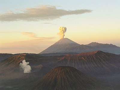

The geography of Indonesia is dominated by volcanoes that are formed due to subduction zones between the Eurasian plate and the Indo-Australian plate. Some of the volcanoes are notable for their eruptions, for instance, Krakatoa for its global effects in 1883,[1] Lake Toba for its supervolcanic eruption estimated to have occurred 74,000 years before present which was responsible for six years of volcanic winter,[2] and Mount Tambora for the most violent eruption in recorded history in 1815.[3]
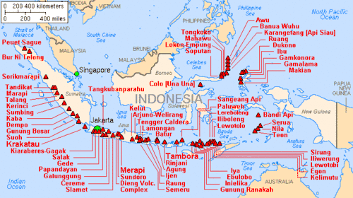
Volcanoes in Indonesia are part of the Pacific Ring of Fire. The 150 entries in the list below are grouped into six geographical regions, four of which belong to the volcanoes of the Sunda Arc trench system. The remaining two groups are volcanoes of Halmahera, including its surrounding volcanic islands, and volcanoes of Sulawesi and the Sangihe Islands. The latter group is in one volcanic arc together with the Philippine volcanoes.
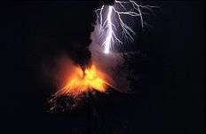
The most active volcanoes are Kelud and Merapi on Java island which have been responsible for thousands of deaths in the region. Since AD 1000, Kelut has erupted more than 30 times, of which the largest eruption was at scale 5 on the Volcanic Explosivity Index (VEI),[4] while Mount Merapi has erupted more than 80 times.[5] The International Association of Volcanology and Chemistry of the Earth's Interior has named Mount Merapi as a Decade Volcano since 1995 because of its high volcanic activity.
As of 2012, Indonesia has 127 active volcanoes and about 5 million people active within the danger zones. It has been conjectured that the earthquake and tsunami event of 26 December 2004 could trigger eruptions, with Mount Sinabung (dormant since the 1600s) erupting in 2010 as a possible example.[6]
The word for Mount in Indonesian and many regional languages of the country is Gunung. Thus, Mount Merapi may be referred to as Gunung Merapi.
Scope
There is no single standard definition for a volcano. It can be defined from individual vents, volcanic edifices or volcanic fields. Interior of ancient volcanoes may have been eroded, creating a new subsurface magma chamber as a separate volcano. Many contemporary active volcanoes rise as young parasitic cones from flank vents or at a central crater. Some volcanic cones are grouped into one volcano name, for instance, the Tengger caldera complex, although individual vents are named by local people. The status of a volcano, either active or dormant, cannot be defined precisely. An indication of a volcano is determined by either its historical records, radiocarbon dating, or geothermal activities.
The primary source of the list below is taken from the Volcanoes of the World book, compiled by two volcanologists Tom Simkin and Lee Siebert,[lower-alpha 1] in which active volcanoes in the past 10,000 years (Holocene) are listed.[7] Particularly for Indonesia, Simkin and Siebert used a catalogue of active volcanoes from the International Association of Volcanology and Chemistry of the Earth's Interior publication series.[lower-alpha 2] The Simkin and Siebert list is the most complete list of volcanoes in Indonesia, but the accuracy of the record varies from one region to another in terms of contemporary activities and fatalities in recent eruptions. Complementary sources for the latest volcanic data are taken from the Volcanological Survey of Indonesia, a governmental institution which is responsible for volcanic activities and geological hazard mitigation in Indonesia,[8] and some academic resources.
Geographical groups
Sumatra
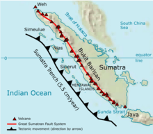
The geography of Sumatra is dominated by a mountain range called Bukit Barisan (lit: "a row of hills"). The mountain range spans nearly 1,700 km (1,100 mi) from the north to the south of the island, and it was formed by movement of the Australian tectonic plate.[9] The plate moves with a convergence rate of 5.5 cm/year which has created major earthquakes on the western side of Sumatra including the 2004 Sumatra–Andaman earthquake.[10][11] The tectonic movement has been responsible not only for earthquakes, but also for the formation of magma chambers beneath the island.[9]
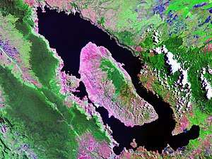
Only one of the 35 active volcanoes, Weh, is separated from the Sumatran mainland. The separation was caused by a large eruption that filled the lowland between Weh and the rest of the mainland with sea water in the Pleistocene epoch. The largest volcano of Sumatra is the supervolcano Toba within the 100 km (62 mi) × 30 km (19 mi) Lake Toba, which was created after a caldera collapse (est. in 74,000 Before Present).[2] The eruption is estimated to have been at level eight on the VEI scale, the largest possible for a volcanic eruption. The highest peak of the mountain range is Mount Kerinci with an elevation of 3,800 m (12,467 ft).
Sunda Strait and Java
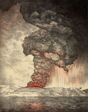
The Sunda Strait separates the islands of Sumatra and Java with the volcanic island Krakatoa lying between them. Krakatau erupted violently in 1883, destroying two-thirds of the island and leaving a large caldera under the sea. This cataclysmic explosion was heard as far away as the island of Rodrigues near Mauritius (approx. 4,800 kilometres (3,000 mi) away).[1] A new parasitic cone, called Anak Krakatau (or the child of Krakatau), rose from the sea at the centre of the caldera in 1930.[12] The other Krakatau islets from the 1883 eruptions are known as Sertung, Panjang and Rakata.
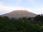
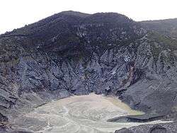
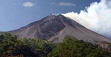
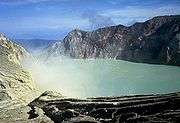
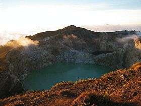
Java is a relatively small island compared to Sumatra, but it has a higher concentration of active volcanoes. There are 45 active volcanoes on the island excluding 20 small craters and cones in the Dieng volcanic complex and the young cones in the Tengger caldera complex. Some volcanoes are grouped together in the list below because of their close location. Mount Merapi, Semeru and Kelud are the most active volcanoes in Java. Mount Semeru has been continuously erupting since 1967.[13] Mount Merapi has been named as one of the Decade Volcanoes since 1995.[14] Ijen has a unique colourful caldera lake which is an extremely acidic natural reservoir (pH<0.3).[15] There are sulphur mining activities at Ijen, where miners collect highly concentrated sulphur rocks by hand.
Note: Height of Krakatau is of Rakata, not of the active Anak Krakatau
Lesser Sunda Islands
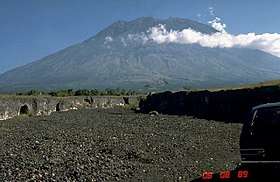
The Lesser Sunda Islands is a small archipelago which, from west to east, consists of Bali, Lombok, Sumbawa, Flores, Sumba and the Timor islands; all are located at the edge of the Australian continental shelf. Volcanoes in the area are formed because of oceanic crusts and the movement of the shelf itself.[17] Some volcanoes completely form an island, for instance, the Sangeang Api island. Mount Tambora, on Sumbawa island, erupted on 5 April 1815, with a scale 7 on the VEI and is considered the most violent eruption in recorded history.[3]
Banda Sea
The Banda Sea in the south of the Molucca archipelago includes a small group of islands. Three major tectonic plates beneath the sea, Eurasian, Pacific and Indo-Australian plates, have been converging since the Mesozoic epoch.[18] Volcanoes in the Banda Sea are mainly islands, but some are submarine volcanoes.
| Name | Shape | Elevation | Last eruption (VEI) | Geolocation |
|---|---|---|---|---|
| Emperor of China | submarine | −2,850 metres (−9,350 ft) | unknown | 6°37′S 124°13′E / 6.62°S 124.22°E |
| Nieuwerkerk | submarine | −2,285 metres (−7,497 ft) | unknown | 6°36′00″S 124°40′30″E / 6.60°S 124.675°E |
| Gunungapi Wetar | stratovolcano | 282 metres (925 ft) | 1699 (3) | 6°38′31″S 126°39′00″E / 6.642°S 126.65°E |
| Wurlali | stratovolcano | 868 metres (2,848 ft) | 3 June 1892 (2) | 7°07′30″S 128°40′30″E / 7.125°S 128.675°E |
| Teon | stratovolcano | 655 metres (2,149 ft) | 3 June 1904 (2) | 6°55′12″S 129°07′30″E / 6.92°S 129.125°E |
| Nila | stratovolcano | 781 metres (2,562 ft) | 7 May 1968 (1) | 6°44′S 129°30′E / 6.73°S 129.50°E |
| Serua | stratovolcano | 641 metres (2,103 ft) | 18 September 1921 (2) | 6°18′S 130°00′E / 6.30°S 130.00°E |
| Manuk | stratovolcano | 282 metres (925 ft) | unknown | 5°31′48″S 130°17′31″E / 5.53°S 130.292°E |
| Banda Api | caldera | 640 metres (2,100 ft) | 9 May 1988 (3) | 4°31′30″S 129°52′16″E / 4.525°S 129.871°E |
Sulawesi and Sangihe Islands
Four peninsulas dominate the shape of Sulawesi island (formerly known as Celebes). The central part is a high mountainous area, but mostly non-volcanic. Active volcanoes are found in the northern peninsula and continuously stretch to the north to Sangihe Islands. The Sangihe Islands mark the border with the Philippines.
Halmahera
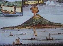
Halmahera island in the north of Molucca archipelago has been formed by the movement of three tectonic plates resulting in two intersecting mountain ranges, which form four rocky peninsulas separated by three deep bays. A volcanic arc stretches from north to south in the west side of Halmahera, some of which are volcanic islands, for instance, Gamalama and Tidore. Gamalama's island name is Ternate and it has been the centre for spice trading since the Portuguese Empire opened a fort in 1512. Due to its location as the centre for spice trading during the Age of Discovery, historical records of volcanic eruptions in Halmahera have been available as far back as the early 16th century.
Major eruptions
Below is a list of selected major eruptions of volcanoes in Indonesia, sorted chronologically by the starting date of the eruption. Only eruptions with scale 3 or above on VEI are given with known sources and fatalities, except if smaller scale eruptions resulted some fatalities.
| Eruption date | Volcano | Cessation date | VEI | Characteristics | Tsunami | Tephra volume | Fatality | Sources |
|---|---|---|---|---|---|---|---|---|
| 3 November 2010 | Merapi | 8 November 2010 | 4 | cv,pf,ld,lm | no | N/A | 353 | [5] |
| 10 February 1990 | Kelut | March 1990 | 4 | cv,cl,pf,ph,ld,lm | no | 0.13 km³ | 35 | [19] |
| 18 July 1983 | Colo | December 1983 | 4 | cv,pf,ph | no | N/A | 0 | [19] |
| 5 April 1982 | Galunggung | 8 January 1983 | 4 | cv,pf,lf,lm | no | 0.37 km³ + | 68 | [20][21] |
| 6 October 1972 | Merapi | March 1985 | 2 | cv,pf,lf,ld,lm | no | 0.021 km³ | 29 | [5] |
| 26 April 1966 | Kelut | 27 April 1966 | 4 | cv,cl,pf,lm | no | 0.089 km³ | 212 | [19] |
| 17 March 1963 | Agung | 27 January 1964 | 5 | cv,pf,lf,lm | no | 1 km³ | 1,148 | [22] |
| 31 August 1951 | Kelut | 31 August 1951 | 4 | cv,cl,pf,lm | no | 0.2 km³ | 7 | [19] |
| 25 November 1930 | Merapi | September 1931 | 3 | cv,rf,pf,lf,ld,lm | no | 0.0017 km³ | 1,369 | [5] |
| 19 May 1919 | Kelut | 20 May 1919 | 4 | cv,cl,pf,lm | no | 0.19 km³ | 5,110 | [19] |
| 7 June 1892 | Awu | 12 June 1892 | 3 | cv,pf,lm | yes | N/A | 1,532 | [23] |
| 26 August 1883 | Krakatoa | February 1884 | 6 | cv,se,pf,fa,lm,cc | 15–42 m | 5–8.5 km³ | 36,600 | [1][22][24] |
| 15 April 1872 | Merapi | 21 April 1872 | 4 | cv,pf | no | 0.33 km³ | 200 | [5] |
| 2 March 1856 | Awu | 17 March 1856 | 3 | cv,pf,lm | yes | 0.51±0.50 km³ | 2,806 | [23] |
| 8 October 1822 | Galunggung | December 1822 | 5 | cv,pf,ld,lm | no | 1 km³ + | 4,011 | [19] |
| 10 April 1815 | Mount Tambora | 15 July 1815 | 7 | cv,pf,cc | 1–2 m | 160 km³ | 71,000+ | [3][25] |
| 6 August 1812 | Awu | 8 August 1812 | 4 | cv,pf,lm | no | 0.55±0.50 km³ | 963 | [23] |
| 12 August 1772 | Papandayan | 12 August 1772 | 3 | cv,ph | no | N/A | 2,957 | [26] |
| 4 August 1672 | Merapi | unknown | 3 | cv,pf,lm | no | N/A | 3,000 | [5] |
| 1586 | Kelut | unknown | 5 | cf,cl,lm | no | 1 km³ + | 10,000 | [19] |
| September 1257 | Samalas | unknown | 7 | [27] | ||||
| ≈ 74,000 BP | Toba | unknown | 8 | pf,lf,cc | likely | 2,800 km³ | Possible near extinction of all the human population | [2] |
See also
References
General references
- ↑ Tom Simkin & Lee Siebert (1994). Volcanoes of the World: A Regional Directory, Gazetteer, and Chronology of Volcanism During the Last 10,000 Years (2nd ed.). Geoscience Press. ISBN 0-945005-12-1.
- ↑ M. Neumann van Padang (1951). "Indonesia". Catalog of Active Volcanoes of the World and Solfatara Fields (1 ed.). Rome: IAVCEI. pp. 1&ndash, 271.
Notes
- 1 2 3 Winchester, Simon (2003). Krakatoa: The Day the World Exploded: August 27, 1883. HarperCollins. ISBN 0-06-621285-5.
- 1 2 3 Oppenheimer, C. (2002). "Limited global change due to the largest known Quaternary eruption, Toba ≈74 kyr BP?". Quaternary Science Reviews. 21 (14&ndash, 15): 1593&ndash, 1609. Bibcode:2002QSRv...21.1593O. doi:10.1016/S0277-3791(01)00154-8.
- 1 2 3 Stothers, Richard B. (1984). "The Great Tambora Eruption in 1815 and Its Aftermath". Science. 224 (4654): 1191–1198. Bibcode:1984Sci...224.1191S. doi:10.1126/science.224.4654.1191. PMID 17819476.
- ↑ "Kelut Eruptive History". Global Volcanism Program. Smithsonian Institution. Retrieved 19 December 2006.
- 1 2 3 4 5 6 "Merapi Eruptive History". Global Volcanism Program. Smithsonian Institution. Retrieved 19 December 2006.
- ↑ "Indonesia Miliki 127 Gunung Api Aktif". 2 May 2012.
- ↑ "Volcano Data Criteria". Global Volcanism Program. Smithsonian Institution. Retrieved 14 June 2015.
- ↑ "Centre of Volcanology & Geological Hazard Mitigation". Volcanological Survey of Indonesia. Archived from the original on 16 December 2006. Retrieved 31 December 2006.
- 1 2 Simoes, M., Avouac, J.P., Cattin, R., Henry, P. (2004). "The Sumatra subduction zone: A case for a locked fault zone extending into the mantle" (PDF). Journal of Geophysical Research. 109: B10402. Bibcode:2004JGRB..10910402S. doi:10.1029/2003JB002958.
- ↑ Subarya, C., Chlieh, M., Prawirodirdjo, L., Avouac, J.P., Bock, Y., Sieh, K., Meltzner, A., Natawidjaja, D.H., McCaffrey, R. (2006). "Plate-boundary deformation associated with the great Sumatra-Andaman earthquake" (PDF). Nature. 440 (7080): 46&ndash, 51. Bibcode:2006Natur.440...46S. doi:10.1038/nature04522. PMID 16511486.
- ↑ Lay, T., Kanamori, H., Ammon, C., Nettles, M., Ward, S., Aster, R., Beck, S., Bilek, S., Brudzinski, M., Butler, R., DeShon, H., Ekstrom, G. (2005). "The Great Sumatra-Andaman Earthquake of 26 December 2004" (PDF). Science. 308 (5725): 1127&ndash, 1133. Bibcode:2005Sci...308.1127L. doi:10.1126/science.1112250. PMID 15905392.
- ↑ Whittaker, R. J.; Bush, M. B. (1993). "Anak Krakatau and old Krakatau: a reply". GeoJournal. 29 (4): 417&ndash, 420. doi:10.1007/BF00807545.
- ↑ "Semeru Weekly Reports". Global Volcanism Program. Smithsonian Institution. Retrieved 7 December 2006.
- ↑ International Association of Volcanology and Chemistry of the Earth's Interior (1995). "Decade Volcano Update". Bulletin of Volcanology. 57 (1): 82&ndash, 83. Bibcode:1995BVol...57...76.. doi:10.1007/BF00298711.
- ↑ Ansje Löhr; Thom Bogaard; Alex Heikens; Martin Hendriks; Sri Sumarti; Manfred van Bergen; Kees C.A.M. van Gestel; Nico van Straalen; Pieter Vroonand & Budi Widianarko (2005). "Natural Pollution Caused by the Extremely Acid Crater Lake Kawah Ijen, East Java, Indonesia". Environmental Science and Pollution Research. 12 (2): 89&ndash, 95. doi:10.1065/espr2004.09.118.
- ↑ "Mount Merapi Erupts". ANTARA. 26 October 2010. Retrieved 19 November 2013.
- ↑ H. A. Brouwer (July 1939). "Exploration in the Lesser Sunda Islands". The Geographical Journal. Blackwell Publishing. 94 (1): 1&ndash, 10. doi:10.2307/1788584. JSTOR 1788584.
- ↑ Christian Honthaasa; Jean-Pierre Réhaulta; René C. Maurya; Hervé Bellona; Christophe Hémonda; Jacques-André Maloda; Jean-Jacques Cornéeb; Michel Villeneuveb; Joseph Cottena; Safri Burhanuddinc; Hervé Guilloud; Nicolas Arnaud (1998). "A Neogene back-arc origin for the Banda Sea basins: geochemical and geochronological constraints from the Banda ridges (East Indonesia)". Tectonophysics. 298 (4): 297&ndash, 317. Bibcode:1998Tectp.298..297H. doi:10.1016/S0040-1951(98)00190-5.
- 1 2 3 4 5 6 7 "Large Holocene Eruptions". Global Volcanism Program. Smithsonian Institution. Retrieved 18 December 2006.
- ↑ Katili, J.A. & Sudradjat, A. (1984). "Galunggung: the 1982-1983 eruption". Volcanology Survei Indonesia: 102.
- ↑ "Galunggung, Java, Indonesia". Volcano World. Department of Geosciences at Oregon State University. Archived from the original on 16 June 2008. Retrieved 30 December 2006.
- 1 2 Michael R. Rampino & Stephen Self (1982). "Historic eruptions of Tambora (1815), Krakatau (1883), and Agung (1963), their stratospheric aerosols, and climatic impact". Quaternary Research. 18 (2): 127&ndash, 143. Bibcode:1982QuRes..18..127R. doi:10.1016/0033-5894(82)90065-5.
- 1 2 3 "Awu's Eruptive History". Global Volcanism Program. Smithsonian Institution. Retrieved 31 December 2006.
- ↑ B.H. Choi; E. Pelinovsky; K.O. Kim; J.S. Lee (2003). "Simulation of the trans-oceanic tsunami propagation due to the 1883 Krakatau volcanic eruption" (PDF). Natural Hazards and Earth System Sciences. 3 (5): 321&ndash, 332. doi:10.5194/nhess-3-321-2003. Archived from the original (PDF) on 12 September 2006.
- ↑ Oppenheimer, Clive (2003). "Climatic, environmental and human consequences of the largest known historic eruption: Tambora volcano (Indonesia) 1815". Progress in Physical Geography. 27 (2): 230–259. doi:10.1191/0309133303pp379ra.
- ↑ "The Deadliest Eruptions". Volcano World. Department of Geosciences at Oregon State University. Archived from the original on 25 January 2009. Retrieved 15 March 2009.
- ↑ Vidal, Céline M.; Komorowski, Jean-Christophe; Métrich, Nicole; Pratomo, Indyo; Kartadinata, Nugraha; Prambada, Oktory; Michel, Agnès; Carazzo, Guillaume; Lavigne, Franck; Rodysill, Jessica; Fontijn, Karen; Surono (8 August 2015). "Dynamics of the major plinian eruption of Samalas in 1257 A.D. (Lombok, Indonesia)". Bulletin of Volcanology. 77 (9): 1–24. Bibcode:2015BVol...77...73V. doi:10.1007/s00445-015-0960-9.
External links
| Wikimedia Commons has media related to Volcanoes of Indonesia. |
| History |  | ||||||
|---|---|---|---|---|---|---|---|
| Geography |
| ||||||
| Politics | |||||||
| Economy | |||||||
| Culture |
| ||||||