Kalimantan
| Kalimantan | |
|---|---|
| Region | |
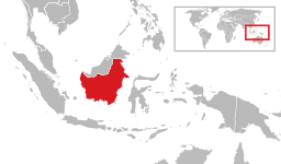 Location of Kalimantan (Indonesia) in Borneo Island | |
| Country |
|
| Province |
|
| Largest Cities |
Balikpapan Banjarmasin Palangkaraya Pontianak Samarinda Tarakan |
| Area | |
| • Total | 544,150.07 km2 (210,097.52 sq mi) |
| Elevation | 2,278 m (7,474 ft) |
| Population (June 2017) | |
| • Total | 15,894,524 |
| • Density | 29/km2 (76/sq mi) |
| Time zones | UTC+7 (Indonesia Western Time) |
| UTC+8 (Indonesia Central Time) | |
| ISO 3166 code | ID-KA |
| Vehicle sign |
DA KB KH KT KU |
| HDI |
|

Kalimantan is the Indonesian portion of the island of Borneo.[1] It comprises 73% of the island's area. The non-Indonesian parts of Borneo are Brunei and East Malaysia. In Indonesia, "Kalimantan" refers to the whole island of Borneo.[1]
Etymology
The name Kalimantan, which is often spelled Klemantan, was derived from the Sanskrit word Kalamanthana, which means "burning weather island", or island with a very hot temperature, to describe its hot and humid tropical climate. It consists of the two words kal[a] (time, season, period) and manthan[a] (boiling, churning, burning). The word Kalamanthana is spelled Kalmantan, and then the indigenous people fixed it into Klemantan.[2]
Area
The Indonesian territory makes up 73% of the island by area, and 69.5% (13,772,543 at the 2010 Census of Indonesia) by population. The non-Indonesian parts of Borneo are of Brunei (400,000) and East Malaysia (5,625,000), the latter comprising the states of Sabah, Sarawak and the federal territory of Labuan. The region within Indonesia is also known as Indonesian Borneo.
Kalimantan's total area is 544,150 square kilometres (210,097 sq mi).[3]
Administration
| Historical population | ||
|---|---|---|
| Year | Pop. | ±% |
| 1971 | 5,154,774 | — |
| 1980 | 6,723,086 | +30.4% |
| 1990 | 9,099,874 | +35.4% |
| 1995 | 10,470,843 | +15.1% |
| 2000 | 11,331,558 | +8.2% |
| 2005 | 12,541,554 | +10.7% |
| 2010 | 14,297,069 | +14.0% |
| 2015 | 15,320,017 | +7.2% |
| sources:BPS[4] | ||
Kalimantan is divided into five provinces. There were four provinces until 25 October 2012, when North Kalimantan was split off from East Kalimantan.
| Province | Area (km2) | Population (2005C) | Pop. (2010C) | Pop. (2015C prelim) | Pop. density/km2 | Provincial capital | Largest metro |
|---|---|---|---|---|---|---|---|
| West Kalimantan (Kalimantan Barat) |
147,307.00 | 4,042,817 | 4,393,239 | 4,783,209 | 32.5 | Pontianak | Pontianak |
| Central Kalimantan (Kalimantan Tengah) |
153,564.50 | 1,913,026 | 2,202,599 | 2,490,178 | 16.2 | Palangkaraya | Palangkaraya |
| South Kalimantan (Kalimantan Selatan) |
38,744.23 | 3,271,413 | 3,626,119 | 3,984,315 | 102.8 | Banjarmasin | Banjarmasin |
| East Kalimantan (Kalimantan Timur) |
129,067 | 2,840,874 | 3,550,586 | 3,422,676* | 26.5 | Samarinda | Balikpapan |
| North Kalimantan (Kalimantan Utara) |
71,176.72 | 473,424 | 524,526 | 639,639 | 8.5 | Tanjung Selor | Tarakan |
| Total | 544,150.07 | 12,541,554 | 14,297,069 | 15,320,017 | 28 | - | Banjarmasin |
* North Kalimantan split off East Kalimantan with resulting population and area loss for 2015 census.
See also
References
- 1 2 "Kalimantan". Britannica. Retrieved 2008-02-26.
- ↑ "Central Kalimantan Province". archipelago fastfact. Retrieved 13 October 2014.
- ↑ "Indonesia General Info". Geohive.com. Archived from the original on 2009-10-15. Retrieved 2009-08-11.
- ↑ "Penduduk Indonesia menurut Provinsi 1971, 1980, 1990, 1995, 2000 dan 2010". Archived from the original on 2013-07-01. Retrieved 2013-07-17.
Further reading
External links

Capital: Jakarta | ||
| Sumatra |  | |
| Java | ||
| Kalimantan | ||
| Lesser Sunda | ||
| Sulawesi | ||
| Maluku | ||
| Papua | ||
| Former | ||
Lists by
| ||