Ernestviller
| Ernestviller | ||
|---|---|---|
| Commune | ||
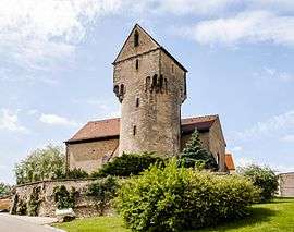 The church in Heckenransbach | ||
| ||
 Ernestviller Location within Grand Est region  Ernestviller | ||
| Coordinates: 49°04′05″N 6°57′54″E / 49.0681°N 6.965°ECoordinates: 49°04′05″N 6°57′54″E / 49.0681°N 6.965°E | ||
| Country | France | |
| Region | Grand Est | |
| Department | Moselle | |
| Arrondissement | Sarreguemines | |
| Canton | Sarralbe | |
| Intercommunality | Communauté d'agglomération Sarreguemines Confluences | |
| Government | ||
| • Mayor (2008–2014) | Roger Heim | |
| Area1 | 4.44 km2 (1.71 sq mi) | |
| Population (1999)2 | 509 | |
| • Density | 110/km2 (300/sq mi) | |
| Time zone | UTC+1 (CET) | |
| • Summer (DST) | UTC+2 (CEST) | |
| INSEE/Postal code | 57197 /57510 | |
| Elevation |
225–276 m (738–906 ft) (avg. 240 m or 790 ft) | |
|
1 French Land Register data, which excludes lakes, ponds, glaciers > 1 km2 (0.386 sq mi or 247 acres) and river estuaries. 2 Population without double counting: residents of multiple communes (e.g., students and military personnel) only counted once. | ||

Ernestviller (German: Ernstweiler) is a commune in the Moselle department in Grand Est in north-eastern France.
See also
| Wikimedia Commons has media related to Ernestviller. |
This article is issued from
Wikipedia.
The text is licensed under Creative Commons - Attribution - Sharealike.
Additional terms may apply for the media files.