White Cloud, Indiana
| White Cloud, Indiana | |
|---|---|
| Unincorporated community | |
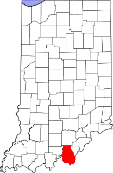 Harrison County's location in Indiana | |
 White Cloud White Cloud's location in Harrison County | |
| Coordinates: 38°13′41″N 86°13′28″W / 38.22806°N 86.22444°WCoordinates: 38°13′41″N 86°13′28″W / 38.22806°N 86.22444°W | |
| Country | United States |
| State | Indiana |
| County | Harrison |
| Township | Harrison |
| Elevation[1] | 456 ft (139 m) |
| ZIP code | 47112 |
| FIPS code | 18-83780[2] |
| GNIS feature ID | 449745 |
White Cloud is an unincorporated community in Harrison Township, Harrison County, Indiana.
History
White Cloud was named for the frequent fog in the area.[3] A post office was established at White Cloud in 1884, and remained in operation until it was discontinued in 1934.[4]
Geography
White Cloud is located at 38°13′41″N 86°13′28″W / 38.22806°N 86.22444°W.
References
- ↑ "US Board on Geographic Names". United States Geological Survey. 2007-10-25. Retrieved 2008-01-31.
- ↑ "American FactFinder". United States Census Bureau. Retrieved 2008-01-31.
- ↑ Baker, Ronald L. (October 1995). From Needmore to Prosperity: Hoosier Place Names in Folklore and History. Indiana University Press. p. 346. ISBN 978-0-253-32866-3.
...the name was suggested by fog that often hangs over the village...
- ↑ "Harrison County". Jim Forte Postal History. Retrieved 17 September 2014.
Municipalities and communities of Harrison County, Indiana, United States | ||
|---|---|---|
| Towns | ||
| Townships | ||
| CDP | ||
| Other unincorporated communities |
| |
| Ghost town | ||
| Footnotes | ‡This populated place also has portions in an adjacent county or counties | |
This article is issued from
Wikipedia.
The text is licensed under Creative Commons - Attribution - Sharealike.
Additional terms may apply for the media files.