Bean Station, Tennessee
| Bean Station, Tennessee | |
|---|---|
| City | |
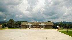 Bean Station Town Hall | |
| Nickname(s): A Historical Crossroad | |
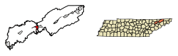 Location of Bean Station in Grainger County, Tennessee | |
 Bean Station Location of Bean Station in Grainger County, Tennessee  Bean Station Bean Station (the US) | |
| Coordinates: 36°20′37″N 83°17′03″W / 36.34361°N 83.28417°W | |
| Country | United States |
| State | Tennessee |
| County | Grainger |
| Settled | 1776 |
| Incorporated | November 1996 |
| Government | |
| • Type | Mayor-Aldermen |
| • Mayor | Terry D. Wolfe |
| • Vice Mayor | Darrel Livesay |
| Area[1] | |
| • Total | 5.387 sq mi (13.95 km2) |
| • Land | 5.386 sq mi (13.95 km2) |
| • Water | 0.001 sq mi (0.003 km2) |
| Elevation | 1,148 ft (350 m) |
| Population (2010)[2] | |
| • Total | 2,826 |
| • Estimate (2016)[3] | 3,109 |
| • Density | 525/sq mi (202.6/km2) |
| Time zone | UTC-5 (Eastern (EST)) |
| • Summer (DST) | UTC-4 (EDT) |
| ZIP code | 37708 |
| Area code(s) | 865 |
| GNIS feature ID | 1276544[4] |
| FIPS code | 47-03760 |
| Website |
www |
Bean Station is a city in Grainger County[5][6] in the U.S. state of Tennessee. As of the 2010 census, the population of Bean Station was 2,826.[2]
Bean Station is located at the junction of U.S. Route 11W and U.S. Route 25E.
The city is a part of the Morristown, Tennessee Metropolitan Statistical Area.
History
Bean Station is rooted in a frontier outpost established in the late 1780s by the sons of William Bean, one of the earliest settlers in Tennessee. The land had likely been observed by Bean while on a long hunting excursion with Daniel Boone several years earlier. The outpost was situated at the intersection of the Old Wilderness Road, a north-south path that roughly followed what is now U.S. Route 25E, and the Old Stage Road, an east-west path that roughly followed modern U.S. Route 11W. This crossroads location made Bean Station an important stopover for early travelers, and at least three taverns and inns were operating at the station by the early 1800s.[7]
During the Civil War, the Battle of Bean's Station took place in December 1863, as Confederate General James Longstreet attempted to capture Bean Station en route to Rogersville after failing to drive Union forces out of Knoxville. Bean Station was held by a contingent of Union soldiers under the command of General James M. Shackelford. After two days of fighting, Union forces were forced to retreat.[7]
Following the war, a businessman named Samuel Tate constructed a large Victorian-style hotel just west of Bean Station that became the focus of a resort known as Tate Springs. In the late 1870s, the hotel was purchased by Captain Thomas Tomlinson, who would transform the property into a vast resort that advertised the healing powers of its mineral springs. At its height, the resort included over three dozen buildings, a 100-acre (40 ha) park, and an 18-hole golf course, and attracted some of the wealthiest people in America. The resort declined during the Great Depression, and the hotel and most of its outbuildings have since been demolished. The Tate Springs Springhouse and its elaborate Victorian gazebo still stand just off Highway 11W, however.[7]
The construction of Cherokee Dam several miles downstream along the Holston River in the early 1940s drastically altered Bean Station's waterfront. A portion of the community was flooded, and at least one historical structure had to be relocated.[7]
On May 13, 1972, 14 people were killed in a head on collision between a Greyhound bus and a tractor-trailer on U.S. Route 11W in Bean Station, which gave U.S. Route 11W the nickname, “Bloody Highway 11W.”[8]
In 2018, Southeastern Provisions, a cattle slaughterhouse near Bean Station[9][10] was raided by U.S. Immigration and Customs Enforcement on April 5, 2018; 11 undocumented migrant workers were arrested and 86 more were detained.[11]
Bean Station was incorporated in 1996.
Geography
Bean Station is located in easternmost Grainger County, where it borders the unincorporated community of Mooresburg at the county line between Grainger and Hawkins counties. The city is situated in the Richland Valley, also knowns as Mooresburg Valley, in a hilly area, with Clinch Mountain to the north and Cherokee Lake to the south. In the western of portion of Bean Station at Tate Springs, two major highways merge, with U.S. Route 25E entering from the northwest, and U.S. Route 11W entering from the southwest. From this point US 25E leads over Clinch Mountain 20 miles (32 km) to Tazewell, while US 11W runs down the Richland Valley 11 miles (18 km) to Rutledge, the Grainger County seat. The highways split again just south of Bean Station's business district, with 11W bypassing the business district and continining northeastward 17 miles (27 km) to Rogersville, and 25E continuing southward across Cherokee Lake 10 miles (16 km) to Morristown. Tennessee State Route 375 also intersects US 25E south of the business district.
According to the U.S. Census Bureau, the city of Bean Station has an area of 5.4 square miles (14.0 km2), of which 0.436 acres (1,763 m2), or 0.01%, are water.[2] The city limits include Wyatt Village, located next to an arm of Cherokee Lake along US 25E south of the original Bean Station. The city limits stretch 8 miles (13 km) along US 25E and 4 miles (6.4 km) along US 11W.
Demographics
| Historical population | |||
|---|---|---|---|
| Census | Pop. | %± | |
| 2010 | 2,826 | — | |
| Est. 2016 | 3,109 | [3] | 10.0% |
| Sources:[12][13] | |||
As of the 2010 United States Census, there were 2,826 people, 1,149 households, and 827 families residing in the city. 96.8% were White, 0.6% Black or African American, 0.5% Native American, 0.1% Asian and 0.7% of two or more races. 2.3% were Hispanic or Latino (of any race).
The average household size was 2.46 and the average family size was 2.88. 25% of households had children under the age of 18 living with them, 51.8% were married couples living together, 6.3% had a male householder with no wife present, and 13.9% were female householders with no husband present. 28% of households were non-families.
The median age in the city was 42.7. 21.7% of residents were under the age of 18, and 16.2% were age 65 years or older.
Education
Bean Station is the site of Bean Station Elementary School, serving Grades PK-6. Rutledge Middle serves those in Grades 7–8. High school students in Bean Station, like all of Grainger County except the Washburn area, attend Grainger High School in nearby Rutledge.
Economy
Holt's IGA Market is the only supermarket in Bean Station. There are a few restaurants in Bean Station, including Subway, a pizza joint, and a small diner. Bean Station's main export is tomatoes and other crops, as it is a rural community.
Bean Station is also home to a golf course,[14] a manufacturing plant,[15] and several fireworks stores. A local rock quarry was closed in 2017.
References
- ↑ "US Gazetteer files: 2010, 2000, and 1990". United States Census Bureau. 2011-02-12. Retrieved 2011-04-23.
- 1 2 3 "Geographic Identifiers: 2010 Demographic Profile Data (G001): Bean Station city, Tennessee". American Factfinder. U.S. Census Bureau. Retrieved February 17, 2017.
- 1 2 "Population and Housing Unit Estimates". Retrieved June 9, 2017.
- ↑ "Bean Station". Geographic Names Information System. United States Geological Survey.
- ↑ "Bean Station, TN – Bean Station, Tennessee Map & Directions – MapQuest". www.mapquest.com. Retrieved 2017-11-14.
- ↑ "Google Maps". Google Maps.
- 1 2 3 4 Ken Coffey, "History of Bean Station," Town of Bean Station official website. Retrieved: 23 July 2015.
- ↑ "Blood on the asphalt: 11W wreck left 14 people dead". Retrieved 2017-11-21.
- ↑ Dorman, Travis; Satterfield, Jamie (April 5, 2018). "ICE raids Grainger County meatpacking plant amid charges owners avoided $2.5M in payroll taxes". Knox News. Retrieved April 7, 2018.
- ↑ Burke, Sheila (April 6, 2018). "Immigration raid takes 97 into custody at Tennessee plant". ABC News. Retrieved April 7, 2018.
- ↑ name="knoxnewsiceraidsgraingercountrymeatpackingplant"
- ↑ "Census of Population and Housing: Decennial Censuses". United States Census Bureau. Archived from the original on 2006-02-08. Retrieved 2012-03-04.
- ↑ "Incorporated Places and Minor Civil Divisions Datasets: Subcounty Resident Population Estimates: April 1, 2010 to July 1, 2012". Population Estimates. U.S. Census Bureau. Archived from the original on 17 June 2013. Retrieved 11 December 2013.
- ↑ ThemeFuse. "Memberships | Clinchview Golf Club". www.clinchviewgolfclub.net. Retrieved 2017-11-14.
- ↑ "Norris Homes in Bean Station, TN with Reviews - YP.com". www.yellowpages.com. Retrieved 2017-11-14.
External links
| Wikimedia Commons has media related to Bean Station, Tennessee. |
Municipalities and communities of Grainger County, Tennessee, United States | ||
|---|---|---|
| City | ||
| Towns | ||
| Unincorporated communities | ||
| Footnotes | ‡This populated place also has portions in an adjacent county or counties | |
Municipalities and communities of Hawkins County, Tennessee, United States | ||
|---|---|---|
| Cities | ||
| Towns | ||
| CDP | ||
| Unincorporated communities | ||
| Ghost town | ||
| Footnotes | ‡This populated place also has portions in an adjacent county or counties | |
Coordinates: 36°20′37″N 83°17′03″W / 36.34361°N 83.28417°W