Ébersviller
| Ébersviller | ||
|---|---|---|
| Commune | ||
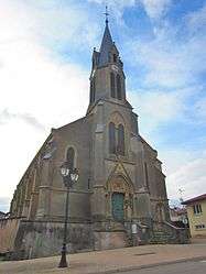 The church in Ébersviller | ||
| ||
 Ébersviller Location within Grand Est region  Ébersviller | ||
| Coordinates: 49°16′39″N 6°24′12″E / 49.2775°N 6.4033°ECoordinates: 49°16′39″N 6°24′12″E / 49.2775°N 6.4033°E | ||
| Country | France | |
| Region | Grand Est | |
| Department | Moselle | |
| Arrondissement | Forbach-Boulay-Moselle | |
| Canton | Bouzonville | |
| Intercommunality | Communauté de communes du Bouzonvillois | |
| Government | ||
| • Mayor (2008–2014) | Edmond Moritz | |
| Area1 | 14.07 km2 (5.43 sq mi) | |
| Population (1999)2 | 660 | |
| • Density | 47/km2 (120/sq mi) | |
| Time zone | UTC+1 (CET) | |
| • Summer (DST) | UTC+2 (CEST) | |
| INSEE/Postal code | 57186 /57320 | |
| Elevation |
210–351 m (689–1,152 ft) (avg. 235 m or 771 ft) | |
|
1 French Land Register data, which excludes lakes, ponds, glaciers > 1 km2 (0.386 sq mi or 247 acres) and river estuaries. 2 Population without double counting: residents of multiple communes (e.g., students and military personnel) only counted once. | ||
.svg.png)
Ébersviller (Lorraine Franconian Ebeschwiller/Ewëschweller, German: Ebersweiler) is a commune in the Moselle department in Grand Est in north-eastern France.
Localities of the commune: Ising (German: Isingen), Férange, Kreschmuhle (German: Kreschmühle), Labrück.
See also
| Wikimedia Commons has media related to Ébersviller. |
This article is issued from
Wikipedia.
The text is licensed under Creative Commons - Attribution - Sharealike.
Additional terms may apply for the media files.