Paragon Estates, Colorado
| Paragon Estates, Colorado | |
|---|---|
| Census-designated place | |
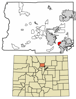 Location of Paragon Estates in Boulder County, Colorado. | |
 Paragon Estates Location of Paragon Estates in Boulder County, Colorado. | |
| Coordinates: 39°58′55″N 105°10′29″W / 39.98194°N 105.17472°WCoordinates: 39°58′55″N 105°10′29″W / 39.98194°N 105.17472°W | |
| Country |
|
| State |
|
| County | Boulder[1] |
| Area | |
| • Total | 1.7 sq mi (4.4 km2) |
| • Land | 1.7 sq mi (4.4 km2) |
| • Water | 0 sq mi (0 km2) |
| Elevation[1] | 5,500 ft (1,700 m) |
| Population (2010) | |
| • Total | 928 |
| • Density | 545/sq mi (210.6/km2) |
| Time zone | UTC-7 (MST) |
| • Summer (DST) | UTC-6 (MDT) |
| GNIS feature ID | 08-57445 |
Paragon Estates is a census-designated place (CDP) in Boulder County, Colorado, United States. The population as of the 2010 Census was 928.[2]
Geography
Paragon Estates is located in southeastern Boulder County on the northwest edge of Louisville and 6 miles (10 km) southeast of Boulder. U.S. Highway 36, the Denver–Boulder Turnpike, forms the southwest edge of the CDP.
According to the U.S. Census Bureau, the Paragon Estates CDP has an area of 1.7 square miles (4.4 km2), of which 0.012 square miles (0.03 km2), or 0.63%, is water.[3]
Demographics
| Historical population | |||
|---|---|---|---|
| Census | Pop. | %± | |
| U.S. Decennial Census[4] | |||
See also
References
- 1 2 "US Board on Geographic Names". United States Geological Survey. 2007-10-25. Retrieved 2008-01-31.
- ↑ Colorado Trend Report 2: State and Complete Places (Sub-state 2010 Census Data). Missouri Census Data Center. Accessed 2011-02-25.
- ↑ "Geographic Identifiers: 2010 Demographic Profile Data (G001): Paragon Estates CDP, Colorado". U.S. Census Bureau, American Factfinder. Retrieved October 18, 2013.
- ↑ "Census of Population and Housing". Census.gov. Retrieved June 4, 2016.
| Wikimedia Commons has media related to Paragon Estates, Colorado. |
Municipalities and communities of Boulder County, Colorado, United States | ||
|---|---|---|
| Cities | 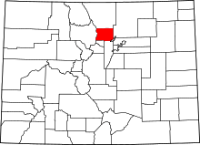 | |
| Towns | ||
| CDPs | ||
| Unincorporated communities | ||
| Ghost town | ||
| Footnotes | ‡This populated place also has portions in an adjacent county or counties | |
This article is issued from
Wikipedia.
The text is licensed under Creative Commons - Attribution - Sharealike.
Additional terms may apply for the media files.