Pinecliffe, Colorado
| Pinecliffe, Colorado | |
|---|---|
| Unincorporated community | |
 Location in Gilpin County and the state of Colorado  Pinecliffe, Colorado (the US) | |
| Coordinates: 39°55′54″N 105°25′44″W / 39.93167°N 105.42889°WCoordinates: 39°55′54″N 105°25′44″W / 39.93167°N 105.42889°W | |
| Country |
|
| State |
|
| Counties | Boulder, Gilpin |
| Elevation[1] | 8,009 ft (2,441 m) |
| Time zone | UTC-7 (MST) |
| • Summer (DST) | UTC-6 (MDT) |
| ZIP code[2] | 80471 |
| GNIS feature ID | 0181137 |
Pinecliffe is a U.S. Post Office and an unincorporated community located in Boulder County and Gilpin County, Colorado, United States. The Pinecliffe Post Office, in Boulder County,[1] has the ZIP Code 80471.[2]
Geography
Pinecliffe is located at 39°55′54″N 105°25′44″W / 39.93167°N 105.42889°W (39.931591,-105.428753).
Gallery
 Train through Pinecliffe
 Pinecliffe, CO
 Pinecliffe, CO
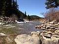 Pinecliffe, CO
 Pinecliffe, CO
 Pinecliffe, CO
 Pinecliffe, CO
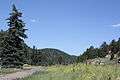 Pinecliffe, CO
 Pinecliffe, CO
 Pinecliffe, CO
 Pinecliffe, CO
 Pinecliffe, CO
 Pinecliffe, CO
 Pinecliffe, CO
 Pinecliffe, CO
 Pinecliffe, CO
 Pinecliffe, CO
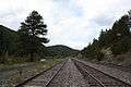 Pinecliffe, CO
 Pinecliffe, CO
 Pinecliffe, CO
 Pinecliffe, CO
References
- 1 2 "US Board on Geographic Names". United States Geological Survey. 2007-10-25. Retrieved 2008-01-31.
- 1 2 "ZIP Code Lookup" (JavaScript/HTML). United States Postal Service. January 2, 2007. Retrieved January 2, 2007.
Municipalities and communities of Boulder County, Colorado, United States | ||
|---|---|---|
| Cities | 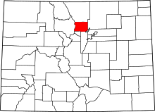 | |
| Towns | ||
| CDPs | ||
| Unincorporated communities | ||
| Ghost town | ||
| Footnotes | ‡This populated place also has portions in an adjacent county or counties | |
Municipalities and communities of Gilpin County, Colorado, United States | ||
|---|---|---|
| Cities |  | |
| CDPs | ||
| Unincorporated communities | ||
| Footnotes | ‡This populated place also has portions in an adjacent county or counties | |

This article is issued from
Wikipedia.
The text is licensed under Creative Commons - Attribution - Sharealike.
Additional terms may apply for the media files.