Firestone, Colorado
| Town of Firestone, Colorado | ||
|---|---|---|
| Statutory Town | ||
 The Firestone Town Hall. | ||
| ||
| Motto(s): “A Community In Motion” | ||
 Location of Firestone in Weld County, Colorado. | ||
| Coordinates: 40°7′53″N 104°56′10″W / 40.13139°N 104.93611°WCoordinates: 40°7′53″N 104°56′10″W / 40.13139°N 104.93611°W | ||
| Country |
| |
| State |
| |
| County[1] | Weld | |
| Incorporated (town) | October 8, 1908[2] | |
| Government | ||
| • Type | Statutory Town[1] | |
| • Body | Firestone Board of Trustees | |
| • Mayor | Bobbi Sindelar | |
| Area[3] | ||
| • Total | 14.15 sq mi (36.64 km2) | |
| • Land | 13.96 sq mi (36.15 km2) | |
| • Water | 0.19 sq mi (0.49 km2) | |
| Elevation[4] | 4,970 ft (1,515 m) | |
| Population (2010) | ||
| • Total | 10,147 | |
| • Estimate (2016)[5] | 12,917 | |
| • Density | 925.42/sq mi (357.31/km2) | |
| Time zone | UTC-7 (MST) | |
| • Summer (DST) | UTC-6 (MDT) | |
| ZIP codes[6] | 80504, 80520 (PO Box) | |
| Area code(s) | 303, 720 | |
| FIPS code | 08-26600 | |
| GNIS feature ID | 0180841 | |
| Website | Town of Firestone website | |
The Town of Firestone is a Statutory Town in Weld County, Colorado, United States. The population was 10,147 at the 2010 census.
History
The town was named for Jacob Firestone, a landowner.[7] The town was incorporated in 1908.[8]
Geography
Firestone is located at 40°7′53″N 104°56′10″W / 40.13139°N 104.93611°W (40.131295, -104.935990),[9] or about 30 miles north of Denver.
According to the United States Census Bureau in 2010, the town has a total area of 10.4 square miles (27 km2).
Demographics
| Historical population | |||
|---|---|---|---|
| Census | Pop. | %± | |
| 1910 | 110 | — | |
| 1920 | 214 | 94.5% | |
| 1930 | 240 | 12.1% | |
| 1940 | 262 | 9.2% | |
| 1950 | 297 | 13.4% | |
| 1960 | 276 | −7.1% | |
| 1970 | 570 | 106.5% | |
| 1980 | 1,204 | 111.2% | |
| 1990 | 1,358 | 12.8% | |
| 2000 | 1,908 | 40.5% | |
| 2010 | 10,147 | 431.8% | |
| Est. 2016 | 12,917 | [5] | 27.3% |
| U.S. Decennial Census[10] | |||
As of the census[11] of 2010, there were 10,147 people and 3,134 households in the town. The population density was 978.5 people per square mile (377.2/km²). There were 3,499 housing units at an average density of 337.4 per square mile (130/km²). The racial makeup of the town was 87.8% White, 0.7% African American, 0.8% Native American, 1.4% Asian, <0.1% Pacific Islander, and 3% from two or more races. Hispanic or Latino of any race were 16.2% of the population.
There were 621 households in 2000 out of which 44.0% had children under the age of 18 living with them, 67.8% were married couples living together, 10.0% had a female householder with no husband present, and 19.0% were non-families. 13.8% of all households were made up of individuals and 2.6% had someone living alone who was 65 years of age or older. The average household size was 3.07 and the average family size was 3.41.
In the town, the population was spread out with 31.7% under the age of 18, 7.8% from 18 to 24, 34.6% from 25 to 44, 21.4% from 45 to 64, and 4.6% who were 65 years of age or older. The median age was 32 years. For every 100 females, there were 96.9 males. For every 100 females age 18 and over, there were 100.3 males.
In 2000, the median income for a household in the town was $55,313, and the median income for a family was $59,219. Males had a median income of $37,230 versus $30,147 for females. The per capita income for the town was $20,428. About 4.7% of families and 7.2% of the population were below the poverty line, including 10.9% of those under age 18 and 9.9% of those age 65 or over.
Points of interest
Firestone has more than thirty-five parks and twelve miles of scenic trail, and the Firestone/Legacy Trail is over twelve miles long located where the old rail road tracks were, that serviced the coal industry, for much of the trail.
Public Schools
Firestone falls within the St. Vrain Valley School District, with three elementary schools (Centennial, Prairie Ridge, and Legacy) and one middle school (Coal Ridge).[12]
Notable People
- Eric Uptagrafft (born 1966), sport shooter
Notable Events
In April 2017, an explosion caused by an untapped gas well destroyed a home on Twilight Avenue, killing two people and seriously injuring a third. This incident prompted a state-wide discussion about fracking and drilling throughout the state. On May 24, 2018, the drilling company responsible for the blast, Anadarko Petroleum Corp., announced it had reached a settlement for an undisclosed sum with the family affected by the blast.[13]
See also
References
- 1 2 "Active Colorado Municipalities". State of Colorado, Department of Local Affairs. Archived from the original on 2010-11-23. Retrieved 2007-09-01.
- ↑ "Colorado Municipal Incorporations". State of Colorado, Department of Personnel & Administration, Colorado State Archives. 2004-12-01. Retrieved 2007-09-02.
- ↑ "2016 U.S. Gazetteer Files". United States Census Bureau. Retrieved Jul 25, 2017.
- ↑ "US Board on Geographic Names". United States Geological Survey. 2007-10-25. Retrieved 2008-01-31.
- 1 2 "Population and Housing Unit Estimates". Retrieved June 9, 2017.
- ↑ "ZIP Code Lookup". United States Postal Service. Archived from the original (JavaScript/HTML) on November 23, 2010. Retrieved September 16, 2007.
- ↑ Dawson, John Frank. Place names in Colorado: why 700 communities were so named, 150 of Spanish or Indian origin. Denver, CO: The J. Frank Dawson Publishing Co. p. 21.
- ↑ "Firestone, Colorado". City-Data.com. Retrieved 2012-11-07.
- ↑ "US Gazetteer files: 2010, 2000, and 1990". United States Census Bureau. 2011-02-12. Retrieved 2011-04-23.
- ↑ "Census of Population and Housing". Census.gov. Archived from the original on May 12, 2015. Retrieved June 4, 2015.
- ↑ "American FactFinder". United States Census Bureau. Archived from the original on 2013-09-11. Retrieved 2008-01-31.
- ↑ St. Vrain Valley School District
- ↑ https://www.denverpost.com/2018/05/23/anadarko-firestone-explosion-lawsuit-settlement/
External links
Municipalities and communities of Weld County, Colorado, United States | ||
|---|---|---|
| Cities | 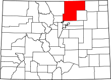 | |
| Towns | ||
| CDP | ||
| Unincorporated communities | ||
| Ghost towns | ||
| Footnotes | ‡This populated place also has portions in an adjacent county or counties | |
