Hidden Lake, Colorado
| Hidden Lake, Colorado | |
|---|---|
| Census-designated place | |
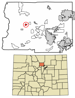 Location of Hidden Lake in Boulder County, Colorado. | |
 Hidden Lake Location of Hidden Lake in Boulder County, Colorado. | |
| Coordinates: 40°6′35″N 105°28′40″W / 40.10972°N 105.47778°WCoordinates: 40°6′35″N 105°28′40″W / 40.10972°N 105.47778°W | |
| Country |
|
| State |
|
| County | Boulder[1] |
| Area | |
| • Total | 0.63 sq mi (1.64 km2) |
| • Land | 0.62 sq mi (1.61 km2) |
| • Water | 0.02 sq mi (0.04 km2) |
| Elevation[1] | 8,740 ft (2,660 m) |
| Population (2010) | |
| • Total | 31 |
| • Density | 50/sq mi (19.3/km2) |
| Time zone | UTC-7 (MST) |
| • Summer (DST) | UTC-6 (MDT) |
| GNIS feature ID | 08-35860 |
Hidden Lake is a census-designated place (CDP) in Boulder County, Colorado, United States. The population as of the 2010 Census was 31.[2]
Geography
Hidden Lake is located in western Boulder County in the Front Range of the Colorado Rocky Mountains. State Highway 72, the Peak to Peak Highway, forms the western edge of the community, leading south 4 miles (6 km) to Ward and 15 miles (24 km) to Nederland, and north 27 miles (43 km) to Estes Park.
According to the U.S. Census Bureau, the Hidden Lake CDP has an area of 0.63 square miles (1.64 km2), of which 0.015 square miles (0.04 km2), or 2.27%, is water.[3]
Demographics
| Historical population | |||
|---|---|---|---|
| Census | Pop. | %± | |
| U.S. Decennial Census[4] | |||
See also
References
- 1 2 "US Board on Geographic Names". United States Geological Survey. 2007-10-25. Retrieved 2008-01-31.
- ↑ Colorado Trend Report 2: State and Complete Places (Sub-state 2010 Census Data). Missouri Census Data Center. Accessed 2011-02-25.
- ↑ "Geographic Identifiers: 2010 Demographic Profile Data (G001): Hidden Lake CDP, Colorado". U.S. Census Bureau, American Factfinder. Retrieved September 27, 2013.
- ↑ "Census of Population and Housing". Census.gov. Retrieved June 4, 2016.
| Wikimedia Commons has media related to Hidden Lake, Colorado. |
Municipalities and communities of Boulder County, Colorado, United States | ||
|---|---|---|
| Cities | 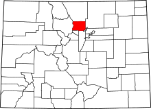 | |
| Towns | ||
| CDPs | ||
| Unincorporated communities | ||
| Ghost town | ||
| Footnotes | ‡This populated place also has portions in an adjacent county or counties | |
This article is issued from
Wikipedia.
The text is licensed under Creative Commons - Attribution - Sharealike.
Additional terms may apply for the media files.