East Staffordshire
| East Staffordshire District | |
|---|---|
| Non-metropolitan district | |
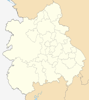
 East Staffordshire shown within Staffordshire | |
| Sovereign state | United Kingdom |
| Constituent country | England |
| Region | West Midlands |
| Non-metropolitan county | Staffordshire |
| Status | Non-metropolitan district |
| Admin HQ | Burton upon Trent |
| Incorporated | 1 April 1974 |
| Government | |
| • Type | Non-metropolitan district council |
| • Body | East Staffordshire Borough Council |
| • Leadership | Leader & Cabinet (Conservative Party) |
| • MPs |
Michael Fabricant Andrew Griffiths |
| Area | |
| • Total | 150.6 sq mi (390.0 km2) |
| Area rank | 104th (of 326) |
| Population (mid-2017 est.) | |
| • Total | 117,600 |
| • Rank | 196th (of 326) |
| • Density | 780/sq mi (300/km2) |
| • Ethnicity |
93.9% White 4.3% S.Asian |
| Time zone | UTC0 (GMT) |
| • Summer (DST) | UTC+1 (BST) |
| ONS code |
41UC (ONS) E07000193 (GSS) |
| OS grid reference | SK2388023478 |
| Website | http://www.eaststaffsbc.gov.uk |
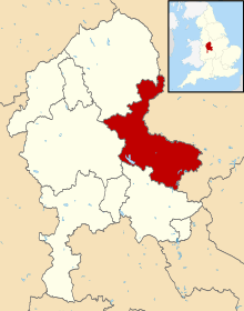
East Staffordshire is a local government district with borough status in Staffordshire in England. It has two main towns: Burton upon Trent, famous for its breweries, and Uttoxeter, renowned for its racecourse.
Villages in the area include Abbots Bromley, Tutbury, Barton-under-Needwood, Rolleston on Dove, Hanbury, Kingstone, Marchington, Mayfield and The Heath.
The borough was formed on 1 April 1974 by the merger of the former county borough of Burton upon Trent with Urban District of Uttoxeter, and Rural Districts of Tutbury and Uttoxeter.
Since 2011, East Staffordshire has formed part of the Greater Birmingham & Solihull Local Enterprise Partnership along with neighbouring authorities Birmingham, Bromsgrove, Cannock Chase, Lichfield, Redditch, Solihull, Tamworth and Wyre Forest.
Wards within East Staffordshire
There are 39 councillors representing 21 wards in East Staffordshire. Most wards have either one or two councillors, but a few have three. The number of councillors is loosely based on the population size in that area.
Political makeup
As of 28 September 2017, East Staffordshire is controlled by the Conservative party with an overall majority of 15 councilors. The Conservative party have 26 councillors, the Labour party have 12 councillors and the Liberal Democrats have one councillor.[1]
Transport
Main roads within the Borough include the A38 through Burton upon Trent and the A50 near Uttoxeter.
There are two railway stations in the Borough, Burton-on-Trent on the Cross Country Route and Uttoxeter on the Crewe to Derby Line, There is also a station serving Tutbury, also on the Crewe to Derby Line called Tutbury and Hatton. This is in the South Derbyshire district.
See also
References
- ↑ http://www.eaststaffsbc.gov.uk/council-democracy/councillors, East Staffordshire Borough Council. Retrieved on 20 October 2017.
External links
- East Staffordshire borough council website
- Enjoy East Staffordshire
- Flickr photos of East Staffordshire
| Unitary authorities | |
|---|---|
| Boroughs or districts | |
| Major settlements | |
| Rivers | |
| Canals | |
| Topics | |