Erewash
| Borough of Erewash | |
|---|---|
| Borough | |
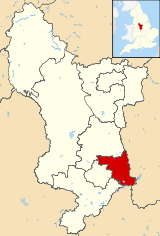 Shown within Derbyshire | |
| Sovereign state | United Kingdom |
| Constituent country | England |
| Region | East Midlands |
| Administrative county | Derbyshire |
| Admin. HQ | Ilkeston |
| Government | |
| • Type | Erewash Borough Council |
| • Leadership: | Leader & Cabinet |
| • Executive: | Conservative |
| • MPs: |
Pauline Latham, Maggie Throup |
| Area | |
| • Total | 42.3 sq mi (109.6 km2) |
| Area rank | 212th |
| Population (mid-2017 est.) | |
| • Total | 115,300 |
| • Rank | Ranked 205th |
| • Density | 2,700/sq mi (1,100/km2) |
| Time zone | UTC+0 (Greenwich Mean Time) |
| • Summer (DST) | UTC+1 (British Summer Time) |
| ONS code |
17UG (ONS) E07000036 (GSS) |
| Ethnicity |
96.7% White 1.3% S.Asian[1] |
| Website | erewash.gov.uk |
Erewash (/ˈɛrəwɒʃ/ (![]()
The borough was formed on 1 April 1974 by the merger of the Borough of Ilkeston, the Long Eaton urban district and part of South East Derbyshire Rural District.
The borough council's headquarters are split between each of the main urban areas at Long Eaton and Ilkeston Town Halls.
Education
The borough is home to the public school, Trent College, The Long Eaton School In Long Eaton, Erewash and its junior / prep school The Elms School.
Broomfield Hall of Derby College is located in Morley.[3]
Derby Japanese School (ダービー日本人補習校 Dābī Nihonjin Hoshūkō), a Japanese weekend school, holds its classes in Broomfield Hall.[3]
External links
| Wikivoyage has a travel guide for Erewash. |
References
- ↑ "Neighbourhood Statistics - Erewash (Local Authority)". Office for National Statistics. 2008-08-29. Retrieved 2008-12-03.
- ↑ "Borough population 2011". Neighbourhood Statistics. Office for National Statistics. Retrieved 23 March 2016.
- 1 2 "ダービー日本人補習校 (Derby Japanese School)." Derby Japanese School. Retrieved on February 14, 2015. " c/o Derby College Broomfield Hall, Morley Ilkeston, Derby DE7 6DN UK"
| Unitary authorities | |
|---|---|
| Boroughs or districts | |
| Major settlements |
|
| Rivers | |
| Topics | |
