Clark County, Indiana
| Clark County, Indiana | |
|---|---|
 Clark County Courthouse in Jeffersonville, Indiana | |
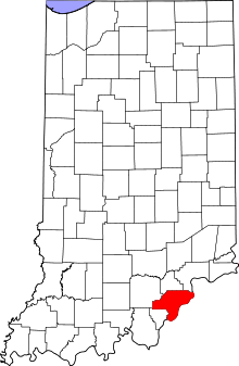 Location in the U.S. state of Indiana | |
 Indiana's location in the U.S. | |
| Founded | February 03, 1801 |
| Named for | General George Rogers Clark |
| Seat | Jeffersonville |
| Largest city | Jeffersonville |
| Area | |
| • Total | 376.45 sq mi (975 km2) |
| • Land | 372.86 sq mi (966 km2) |
| • Water | 3.60 sq mi (9 km2), 0.96% |
| Population | |
| • (2010) | 110,232 |
| • Density | 294/sq mi (113.49/km2) |
| Congressional district | 9th |
| Time zone | Eastern: UTC−5/−4 |
| Website |
www |
|
Footnotes:
Indiana county number 10
| |
Clark County is a county located in the U.S. state of Indiana, located directly across the Ohio River from Louisville, Kentucky. At the 2010 Census, the population was 110,232.[1] The county seat is Jeffersonville.[2]
Clark County is part of the Louisville/Jefferson County, KY–IN Metropolitan Statistical Area.
History
Clark County lies on the north bank of the Ohio River. A significant gateway to the state of Indiana, Clark County's settlement began in 1783. The state of Virginia rewarded General George Rogers Clark and his regiment for their victorious capture of Forts Kaskaskia, Cahokia, and Vincennes from the British by granting them 150,000 acres (610 km2) of land. A small portion of this land, 1,000 acres (4.0 km2), became known as Clarksville, the first authorized American settlement in the Northwest Territory, founded the next year in 1784.[3]
Clark County was formed On February 3, 1801 from Knox County. Counties later formed all or in part from Clark County were: Crawford (1818), Decatur (1822), Fayette (1819), Floyd (1819), Franklin (1811), Harrison (1808), Jackson (1816), Jefferson (1811), Jennings (1817), Randolph (1818), Ripley (1816), Rush (1822), Scott (1820), Switzerland (1814), Union (1821), Washington (1814), and Wayne (1811).[4]
The first county seat and court was established in Springville, Indiana on April 7, 1801.[3] The platting of Jeffersonville occurred a year later and the county seat was fixed to Jeffersonville on June 9, 1802 by order of Governor William Henry Harrison. By December 14, 1810 the county seat changed for the third time to Charlestown and it would remain there until 1873. The county seat changed for one last time on September 23, 1873 and returned to Jeffersonville with then mayor Luther Warder campaigning for the county seat's return.
From its beginning Clark County's history, culture and growth have been linked to the development of the river. The use of the steamboat in the early nineteenth century to transport goods and services provided Clark County opportunities for commercial and industrial growth. In 1832, James Howard founded the Howard shipyards making Clark County a leader in ship building and bringing with it economic growth.[5]
The railroad brought further economic growth. Two railroad lines, the Monon, which spanned from New Albany to Chicago and the Jeffersonville, Madison, and Indianapolis Railroad, provided Clark County and southern Indiana with access to the northern trading centers of Indianapolis and Chicago.
Industries locating to Clark County during the nineteenth century included the Louisville Cement Company in Speed, Indiana and the Ford Plate Glass Company established in Jeffersonville in 1876.
During the 1920s, Clark County attracted the Colgate-Palmolive Company to the Clarksville Riverfront. Colgate purchased the former Indiana Reformatory building in 1923. The company rehabilitated and adapted the building for its dedication in 1924. They stayed in business until early 2008.[5]
Throughout the years of the Second World War, Clark County prospered. The United States began construction on the Indiana Arsenal near Charlestown in 1940.[5] Producing smokeless powder for the conflict overseas, the arsenal, at times, employed as many as 20,000. During the war, Howard shipyards was Commissioned by the Navy to produce landing craft. Later Howard shipyards reorganized as Jeffersonville Boat and Machine Company (Jeffboat) — a current major employer (1991).[5]
After World War II ended, Clark County as well as the United States experienced significant residential and commercial growth. The Interstate Highway System act of 1956 aided this growth. Because of the improved access and efficiency brought by the interstate system, especially Interstate 65, new development in the form of subdivisions and shopping centers located near these roads.
Clark County history has been closely associated with the development of the Ohio River. From its beginnings, Clark County relied on the river for economic opportunities. Clark County has diversified its economic base, lessened its dependency on the river, and continues to develop in new directions. However, the county still looks to the river as one link to its significant pioneer heritage.
Geography
According to the 2010 census, the county has a total area of 376.45 square miles (975.0 km2), of which 372.86 square miles (965.7 km2) (or 99.05%) is land and 3.60 square miles (9.3 km2) (or 0.96%) is water.[6]
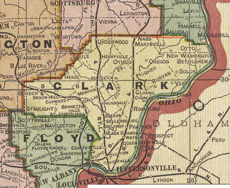
Adjacent counties
- Scott County - north
- Jefferson County - northeast
- Trimble County, Kentucky - east
- Oldham County, Kentucky - southeast
- Jefferson County, Kentucky - south
- Floyd County - west
- Washington County - northwest
Cities
Towns
Census-designated places
Other unincorporated places
- Belknap
- Bennettsville
- Bethlehem
- Black Diamond
- Blue Lick
- Broom Hill
- Carwood
- Cementville
- Clarke
- Dallas
- Dyeton
- Floyd
- Hamburg
- Haussdale
- Henze
- Hibernia
- Hughes
- Marysville
- Nabb
- Oak Park
- Otisco
- Otto
- Owen
- Prather
- Pulltight
- Rockford
- Runyan
- Slatecut
- Solon
- Speed
- St Joseph
- Starlight
- Sunset Village
- Underwood
- Vesta
- Watson
- Wilson
Extinct towns
- Andalusia
- Claysburg
- Oregon
- Port Fulton
- Springville
Townships
Major highways
Airport
- KJVY - Clark Regional Airport
Climate and weather
| Jeffersonville, Indiana | ||||||||||||||||||||||||||||||||||||||||||||||||||||||||||||
|---|---|---|---|---|---|---|---|---|---|---|---|---|---|---|---|---|---|---|---|---|---|---|---|---|---|---|---|---|---|---|---|---|---|---|---|---|---|---|---|---|---|---|---|---|---|---|---|---|---|---|---|---|---|---|---|---|---|---|---|---|
| Climate chart (explanation) | ||||||||||||||||||||||||||||||||||||||||||||||||||||||||||||
| ||||||||||||||||||||||||||||||||||||||||||||||||||||||||||||
| ||||||||||||||||||||||||||||||||||||||||||||||||||||||||||||
In recent years, average temperatures in Jeffersonville have ranged from a low of 25 °F (−4 °C) in January to a high of 87 °F (31 °C) in July, although a record low of −22 °F (−30 °C) was recorded in January 1994 and a record high of 107 °F (42 °C) was recorded in July 1936. Average monthly precipitation ranged from 2.79 inches (71 mm) in October to 4.88 inches (124 mm) in May.[9]
Two towns in Clark County, Marysville and Henryville suffered major damage during the tornado outbreak of March 2–3, 2012.[10]
Government
The county government is a constitutional body, and is granted specific powers by the Constitution of Indiana, and by the Indiana Code.
County Council: The seven member county council is the legislative branch of the county government and controls all the spending and revenue collection in the county. Four representatives are elected from county districts, and three are elected at large. The council members serve four-year terms. They are responsible for setting salaries, the annual budget, and special spending. The council also has limited authority to impose local taxes, in the form of an income and property tax that is subject to state level approval, excise taxes, and service taxes.[11][12]
Board of Commissioners: The executive body of the county is made of a board of commissioners. The commissioners are elected county-wide, in staggered terms, and each serves a four-year term. One of the commissioners, typically the most senior, serves as president. The commissioners are charged with executing the acts legislated by the council, collecting revenue, and managing the day-to-day functions of the county government.[11][12]
Courts: The Clark County Judicial System consists of 8 Courts:
Clark Circuit Court (Judge Daniel Moore) Clark Superior Court #1 (Judge Vicki Carmichael) Clark Superior Court #2 (Judge Jerome Jacobi) Clark Superior Court #3 (Judge Joe P. Weber) Jeffersonville City Court - Office Expired December 31, 2015 Charlestown City Court (Judge George Waters) Clarksville Town Court (Judge Samuel Gwin) Sellersburg Town Court (Judge Thomas Lowe)
By statute, the Circuit and Superior Courts have unlimited jurisdiction with the power to hear all civil and criminal cases. City and Town Courts have jurisdiction to hear Ordinance violations and misdemeanor prosecutions, as well as civil actions where the amount in controversy does not exceed five hundred dollars ($500). Judgments in the City and Town Courts may be appealed de novo to the Clark Circuit Court. In addition, Clark Superior Court #3 maintains a Small Claims Docket. Local Rules of Practice may also limit the ability of a Court to hear certain cases. Judgments in other Courts may be appealed to the Indiana Court of appeals or the Indiana Supreme Court.
The Circuit and Superior Court Judges are assisted by 3 Magistrates, who are appointed and serve at the direction of the elected Judges.
The Circuit and Superior Court Judges are elected on a partisan basis, must reside within the county, and serve six-year terms. The City and Town Court Judges are elected on a partisan basis, must reside within the City/Town, and serve four-year terms.
Felony and Misdemeanor prosecutions are filed by the Prosecuting Attorney, who is elected on a partisan basis, must reside within the county, and serves a term of four years. The current Prosecuting Attorney, Steven D. Stewart, has been in Office since 1989. [12]
County Officials: The county has several other elected offices, including prosecuting attorney, sheriff, coroner, auditor, treasurer, recorder, surveyor, and circuit court clerk. Each of these elected officers serves a term of four years and oversees a different part of county government. Members elected to county government positions are required to declare a party affiliation and to be residents of the county.[12]
Elected county officials
Clark County is part of Indiana's 9th congressional district and is represented in Congress by Republican Trey Hollingsworth.;[13] Indiana Senate districts 45 and 46;[14] and Indiana House of Representatives districts 66, 70, 71, 72 and 73.[15]
The Clark County building is located on Court Avenue in downtown Jeffersonville, and has a council of 7 elected officials. The Clark County Council of 2015 includes:[16]
- Barbara C. Hollis (President)
- Brian Lenfert (Vice President)
- Danny Yost
- Steve Doherty
- Kevin Vissing
- Joe Hubbard
- Kelly Khuri
- Scott Lewis (Attorney)
The three elected Clark County Commissioners are:
- Jack Coffman
- Rick Stephenson
- Bryan Glover
Other county office holders are as follows:
- Prosecutor: Jeremy Mull
- Sheriff: Jamey Noel
- Clerk: Susan Popp
- Auditor: Monty Snelling
- Treasurer: David Reinhardt
- Recorder: Zach Payne
- Assessor: Vicki Kent-Haire
- Surveyor: David Blankenbeker
| Year | Republican | Democratic | Third parties |
|---|---|---|---|
| 2016 | 58.0% 30,035 | 36.3% 18,808 | 5.7% 2,946 |
| 2012 | 53.8% 25,450 | 44.0% 20,807 | 2.2% 1,021 |
| 2008 | 52.9% 25,326 | 45.9% 21,953 | 1.3% 605 |
| 2004 | 57.9% 24,495 | 41.7% 17,648 | 0.5% 194 |
| 2000 | 52.0% 19,417 | 46.5% 17,360 | 1.5% 559 |
| 1996 | 40.1% 14,396 | 49.6% 17,799 | 10.4% 3,721 |
| 1992 | 36.3% 13,333 | 47.6% 17,460 | 16.1% 5,901 |
| 1988 | 53.0% 16,544 | 46.6% 14,528 | 0.4% 120 |
| 1984 | 57.5% 19,419 | 41.9% 14,138 | 0.7% 228 |
| 1980 | 49.7% 15,508 | 45.3% 14,137 | 4.9% 1,536 |
| 1976 | 42.8% 12,732 | 56.1% 16,670 | 1.1% 329 |
| 1972 | 59.4% 16,111 | 40.0% 10,838 | 0.6% 164 |
| 1968 | 38.3% 10,305 | 42.8% 11,493 | 18.9% 5,088 |
| 1964 | 30.6% 7,701 | 68.9% 17,330 | 0.5% 125 |
| 1960 | 46.9% 12,803 | 52.9% 14,431 | 0.3% 70 |
| 1956 | 51.1% 12,483 | 48.6% 11,871 | 0.3% 79 |
| 1952 | 48.6% 11,190 | 50.8% 11,703 | 0.6% 132 |
| 1948 | 38.6% 7,001 | 60.3% 10,953 | 1.1% 199 |
| 1944 | 42.4% 7,241 | 57.2% 9,778 | 0.4% 62 |
| 1940 | 40.0% 6,044 | 59.7% 9,015 | 0.3% 45 |
| 1936 | 34.8% 5,536 | 63.6% 10,116 | 1.5% 244 |
| 1932 | 37.9% 5,881 | 61.2% 9,501 | 0.9% 140 |
| 1928 | 56.4% 8,056 | 43.4% 6,193 | 0.3% 36 |
| 1924 | 51.7% 5,944 | 45.4% 5,218 | 2.9% 336 |
| 1920 | 48.4% 6,466 | 50.4% 6,729 | 1.2% 162 |
| 1916 | 46.2% 3,173 | 52.0% 3,572 | 1.9% 131 |
| 1912 | 11.9% 805 | 48.9% 3,315 | 39.2% 2,655 |
| 1908 | 46.6% 3,706 | 51.3% 4,085 | 2.1% 168 |
| 1904 | 48.8% 3,644 | 48.0% 3,587 | 3.2% 237 |
| 1900 | 47.8% 3,855 | 51.2% 4,134 | 1.0% 79 |
| 1896 | 50.2% 3,897 | 48.8% 3,785 | 1.0% 76 |
| 1892 | 44.2% 3,280 | 54.1% 4,013 | 1.7% 122 |
| 1888 | 45.5% 3,206 | 53.8% 3,788 | 0.7% 49 |
Demographics
| Historical population | |||
|---|---|---|---|
| Census | Pop. | %± | |
| 1810 | 5,670 | — | |
| 1820 | 8,709 | 53.6% | |
| 1830 | 10,686 | 22.7% | |
| 1840 | 14,595 | 36.6% | |
| 1850 | 15,828 | 8.4% | |
| 1860 | 20,502 | 29.5% | |
| 1870 | 24,770 | 20.8% | |
| 1880 | 28,610 | 15.5% | |
| 1890 | 30,259 | 5.8% | |
| 1900 | 31,835 | 5.2% | |
| 1910 | 30,260 | −4.9% | |
| 1920 | 29,381 | −2.9% | |
| 1930 | 30,764 | 4.7% | |
| 1940 | 31,020 | 0.8% | |
| 1950 | 48,330 | 55.8% | |
| 1960 | 62,795 | 29.9% | |
| 1970 | 75,876 | 20.8% | |
| 1980 | 88,838 | 17.1% | |
| 1990 | 87,774 | −1.2% | |
| 2000 | 96,472 | 9.9% | |
| 2010 | 110,232 | 14.3% | |
| Est. 2016 | 116,031 | [20] | 5.3% |
| U.S. Decennial Census[21] 1790-1960[22] 1900-1990[23] 1990-2000[24] 2010-2013[1] | |||
As of the 2010 United States Census, there were 110,232 people, 44,248 households, and 29,474 families residing in the county.[25] The population density was 295.6 inhabitants per square mile (114.1/km2). There were 47,776 housing units at an average density of 128.1 per square mile (49.5/km2).[6] The racial makeup of the county was 87.1% white, 6.9% black or African American, 0.8% Asian, 0.3% American Indian, 2.6% from other races, and 2.2% from two or more races. Those of Hispanic or Latino origin made up 4.9% of the population.[25] In terms of ancestry, 24.3% were German, 15.0% were Irish, 13.0% were American, and 9.8% were English.[26]
Of the 44,248 households, 32.6% had children under the age of 18 living with them, 48.4% were married couples living together, 12.9% had a female householder with no husband present, 33.4% were non-families, and 27.6% of all households were made up of individuals. The average household size was 2.46 and the average family size was 2.98. The median age was 37.9 years.[25]
The median income for a household in the county was $47,697 and the median income for a family was $58,090. Males had a median income of $43,053 versus $32,361 for females. The per capita income for the county was $23,592. About 9.0% of families and 11.8% of the population were below the poverty line, including 17.9% of those under age 18 and 7.5% of those age 65 or over.[27]
Education
There are three separate public school districts and the Archdiocese of Indianapolis that serve the entirety of Clark County. The county is also served by two colleges that offer associates to bachelor's degrees.
Public school districts
|
Clarksville Community School Corp.[28]
West Clark Community School Corp.[29]
|
Greater Clark County Schools[30]
|
Private schools
- Our Lady of Providence Junior-Senior High School[31]
- St. Anthony of Padua Elementary School(K-7) [32]
- Sacred Heart of Jesus (PK-8) [33]
- St. Paul's School(K-6) [34]
Colleges and universities
See also
References
- 1 2 "Clark County QuickFacts". United States Census Bureau. Retrieved 2011-09-17.
- ↑ "Find a County". National Association of Counties. Archived from the original on 2011-05-31. Retrieved 2011-06-07.
- 1 2 "Clark County, Indiana Genealogical Records Information". Archived from the original on 2008-01-21.
- ↑ AniMap County Boundary Historical Atlas. (Gold Bug Software, Alamo, CA)
- 1 2 3 4 "Clark County Government - History". Wayback.archive.org. 2013-03-19. Archived from the original on March 19, 2013. Retrieved 2013-11-19.
- 1 2 "Population, Housing Units, Area, and Density: 2010 - County". United States Census Bureau. Retrieved 2015-07-10.
- ↑ Clark County State Bank. "Clark County 1918 Indiana". historicmapworks.com. Historic Map Works. Retrieved 7 September 2014.
- ↑ Clark County State Bank. "Clark County 1918 Indiana". mygenealogyhound.com. My Genealogy Hound. Retrieved 15 October 2015.
- 1 2 "Monthly Averages for Jeffersonville, Indiana". The Weather Channel. Retrieved 2011-01-27.
- ↑ "The day in pictures - USATODAY.com Photos". Mediagallery.usatoday.com. Retrieved 2012-05-31.
- 1 2 Indiana Code. "Title 36, Article 2, Section 3". IN.gov. Retrieved 2008-09-16.
- 1 2 3 4 Indiana Code. "Title 2, Article 10, Section 2" (PDF). IN.gov. Retrieved 2008-09-16.
- ↑ "Conressman Trey Hollingsworth". House.Gov. Retrieved 2017-11-19.
- ↑ "Indiana Senate Districts". State of Indiana. Retrieved 2011-01-23.
- ↑ "Indiana House Districts". State of Indiana. Retrieved 2011-01-23.
- ↑ "Welcome To Clark County Government". Co.clark.in.us. Archived from the original on 2014-03-19. Retrieved 2014-03-19.
- ↑ "Archived copy". Archived from the original on 2014-03-19. Retrieved 2014-03-19.
- ↑ "Archived copy". Archived from the original on 2015-03-18. Retrieved 2015-03-14.
- ↑ Leip, David. "Dave Leip's Atlas of U.S. Presidential Elections". uselectionatlas.org. Retrieved 4 April 2018.
- ↑ "Population and Housing Unit Estimates". Retrieved June 9, 2017.
- ↑ "U.S. Decennial Census". United States Census Bureau. Archived from the original on May 12, 2015. Retrieved July 10, 2014.
- ↑ "Historical Census Browser". University of Virginia Library. Retrieved July 10, 2014.
- ↑ "Population of Counties by Decennial Census: 1900 to 1990". United States Census Bureau. Retrieved July 10, 2014.
- ↑ "Census 2000 PHC-T-4. Ranking Tables for Counties: 1990 and 2000" (PDF). United States Census Bureau. Retrieved July 10, 2014.
- 1 2 3 "DP-1 Profile of General Population and Housing Characteristics: 2010 Demographic Profile Data". United States Census Bureau. Retrieved 2015-07-10.
- ↑ "DP02 SELECTED SOCIAL CHARACTERISTICS IN THE UNITED STATES – 2006-2010 American Community Survey 5-Year Estimates". United States Census Bureau. Retrieved 2015-07-10.
- ↑ "DP03 SELECTED ECONOMIC CHARACTERISTICS – 2006-2010 American Community Survey 5-Year Estimates". United States Census Bureau. Retrieved 2015-07-10.
- ↑ "Clarksville Community Schools". Ccsc.k12.in.us. 2009-07-16. Archived from the original on 2007-12-16. Retrieved 2009-09-21.
- ↑ "West Clark Community Schools". Wclark.k12.in.us. Retrieved 2009-09-21.
- ↑ "Greater Clark County Schools". Gcs.k12.in.us. Retrieved 2009-09-21.
- ↑ "Welcome | Our Lady of Providence Junior-Senior High School". Providencehigh.net. Retrieved 2009-09-21.
- ↑ "Welcome to St. Anthony of Padua Catholic School in Clarksville, Indiana". Stanthonyschool.us. Retrieved 2009-09-21.
- ↑ "Home". sacredheartschool.us. Archived from the original on 2009-02-23. Retrieved 2009-09-21.
- ↑ "St. Paul's Catholic School". Web.archive.org. 2006-10-12. Archived from the original on 2006-10-12. Retrieved 2009-09-21.
- ↑ "Ivy Tech Community College". Ivytech.edu. Retrieved 2009-09-21.
- ↑ "Mid-America College of Funeral Service Education Mortuary Profession School Jeffersonville, Indiana". Mid-america.edu. Retrieved 2009-09-21.
- ↑ "Ottawa University - Ottawa University". Ottawa.edu. 2009-01-09. Retrieved 2009-09-21.
External links
Places adjacent to Clark County, Indiana | |
|---|---|
Municipalities and communities of Clark County, Indiana, United States | ||
|---|---|---|
| Cities | ||
| Towns | ||
| Townships | ||
| CDPs | ||
| Unincorporated communities |
| |
| Footnotes | ‡This populated place also has portions in an adjacent county or counties | |
