Indiana State Road 3
| ||||
|---|---|---|---|---|
 | ||||
| Route information | ||||
| Maintained by INDOT | ||||
| Length | 225.148 mi[1] (362.341 km) | |||
| Existed | October 1, 1926[2] – present | |||
| Southern segment | ||||
| Length | 180.352 mi (290.248 km) | |||
| South end |
| |||
| Major junctions |
| |||
| North end |
| |||
| Northern segment Lima Road | ||||
| Length | 44.796 mi (72.092 km) | |||
| South end |
| |||
| Major junctions |
| |||
| North end |
| |||
| Location | ||||
| Counties | Clark, Scott, Jennings, Decatur, Rush, Henry, Delaware, Blackford, Wells, Huntington, Allen, DeKalb, Noble, LaGrange | |||
| Highway system | ||||
| ||||

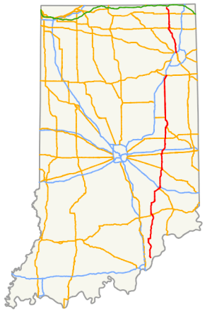
State Road 3 (SR 3) in the U.S. State of Indiana is a discontinuous state highway running through eastern Indiana from near the Ohio River to near the Michigan state line. The southernmost terminus is at State Road 62 in Charlestown, and the northernmost terminus is at State Road 120 near Brighton.
The route was continuous until 1972, when the route was split into two segments that exist today.
Route description
Southern section
SR 3 begins just south of Charlestown at SR 62 and heads north toward downtown Charlestown. When in downtown Charlestown SR 3 has an intersection with State Road 403 (SR 403). SR 3 heads north out of Charlestown. Then 17.17 miles (27.63 km) north of SR 403 there is a wrong-way concurrency with State Road 203 (SR 203) for 1.85 miles (2.98 km), meaning southbound SR 203 and northbound SR 3 are going the same direction. After SR 203, SR 3 heads north toward Vernon and then North Vernon. In North Vernon SR 3 has an intersection with U.S. Route 50 (US 50). After North Vernon SR 3 heads mainly due north for 22.52 miles (36.24 km) until State Road 46 (SR 46) just west of Greensburg. SR 3 joins SR 46 on a four-lane divided highway and then enters Greensburg from the southwest. After entering Greensburg SR 46 leaves SR 3 at Main Street. In downtown Greensburg SR 3 has an intersection with U.S. Route 421 (US 421).[3]

After US 421, SR 3 leaves Greensburg heading northeast, then just north. SR 3 has an interchange with Interstate 74 (I-74), 1.53 miles (2.46 km) from US 421. After I-74, SR 3 becomes a two-lane undivided highway. SR 3 has a concurrency with U.S. Route 52 (US 52) that lasts for 0.42 miles (0.68 km) in Rushville. SR 3 heads due north toward U.S. Route 40 (US 40) and then SR 3 heads east on US 40 for a short concurrency after 0.07 miles (0.11 km). After US 40, SR 3 has an interchange with interstate 70 (I-70), exit number 123 on I-70. Just south of I-70 SR 3 becomes a four-lane divided highway. After I-70, SR 3 passes near New Castle. SR 3 and U.S. Route 36 (US 36) have an interchange near Mount Summit. After US 36, SR 3 head north toward Muncie, where SR 3 has an interchange with State Road 67 (SR 67).[4]
At the interchange with SR 67, SR 3 heads east, then north along the bypass. Interchange includes U.S. Route 35 (US 35) south, State Road 32 (SR 32), and SR 67 north. The bypass is a limited-access highway.[5]
North of the Muncie Bypass, US 35 leaves SR 3 due west to Kokomo. After US 35, SR 3 heads due north to Markle. Passing through Hartford City, where SR 3 meets State Road 26 (SR 26). South of Markle SR 3 turns northeast, then SR 3 meets State Road 116 (SR 116). Then 0.46 miles (0.74 km) after SR 116, SR 3 comes to its northern terminus of the southern section of SR 3, at U.S. Route 224 (US 224).[6]
Northern section
The southern terminus of the northern section of SR 3 begins at Interstate 69 (I-69) and the northern terminus of U.S. Route 27 (US 27). The road heads North from this point, as a six–lane major arterial passing through both commercial and residenteal areas. North of Dupont Road, on the northside of Fort Wayne, the road becomes a rural four–lane divided highway. North of Fort Wayne, the route bypasses Huntertown, 8.20 miles (13.20 km) north of I-69. The road then enters Dekalb County with and traffic light at State Road 205 (SR 205). Very soon after SR 205, the road enters Noble County, bypassing LaOtto and Avilla. In Noble County, the route passes through rural farming land and parallels an abandoned railroad track on its way to Kendallville. In Kendallville the route has a short concurrency with US 6. After the US 6 concurrency SR 3, becomes a two–lane rural highway heading due North, until Mongo where the road turns northwest. Entering into Brighton, SR 3 reaches its northern terminus at SR 120.[7]
History
Between 1972 and 1973, SR 3 was removed between US 224 in Markle and I-69 on the north side of Fort Wayne. The final route through the Fort Wayne metro area followed Indianapolis Road/Baer Road past the city's main airport (then known as Baer Field) to Lower Huntington Road in the Waynedale district of Fort Wayne. SR 3 there turned east onto that road for only a short distance, before turning north again onto Bluffton Road (SR 1). Bluffton Road hugs the bank of the St. Mary's River before curving east and crossing it. SR 1 and SR 3 then immediately turned south onto Broadway for two blocks before turning east onto Rudisill Boulevard. SR 1/SR 3 followed Rudisill Boulevard to Lafayette Street (US 27/US 33 northbound) and Clinton Street (US 27/US 33 southbound) at which points the state routes turned north to join the others heading to/from downtown Fort Wayne. In the heart of the city US 33 departed, then upon leaving downtown Lafayette Street becomes Spy Run Boulevard (still one way northbound) before joining Clinton Street on the north side of the city. Shortly thereafter, US 27/SR 1/SR 3 turned toward the northwest onto Northrop Street and Lima Road until they reached the I-69 interchange, where SR 3 continued north on Lima Road and US 27/SR 1 turned east onto northbound I–69. With SR 3 through traffic easily using the then-recently completed I-69 to bypass Fort Wayne, the route between US 224 and the junction with SR 1 on the southwest side was turned back over to local control and the SR 3 designation was removed along the portions shared with other routes within the city.[8][9]
Until 1980, SR 3 was concurrent with SR 62 until it reached Interstate 65 in Jeffersonville.[10]
In 1990, the four-lane upgrade from the DeKalb/Allen County line north of Huntertown to Kendallville was completed, bypassing the towns of LaOtto and Avilla. This made SR 3 four lanes for the 25 miles (40 km) from I-69 in Fort Wayne to US 6 in Kendallville.[11]
In early 2010, construction began on SR 3 widening for about 3 miles (4.8 km) from Ludwig Road in Fort Wayne to Dupont Road on the north side of Fort Wayne. This section of highway along Lima Road was widened from four lane divided roadway to six lane divided highway and was completed in November 2011.[12][13]
At one point, the northern terminus was at the Michigan State Line.
Major intersections
| County | Location | mi[1] | km | Destinations | Notes | ||
|---|---|---|---|---|---|---|---|
| Clark | Charlestown | 0.000 | 0.000 | Southern terminus of SR 3 | |||
| 1.137 | 1.830 | former SR 403 south | |||||
| Oregon Township | 11.409 | 18.361 | former SR 203 north | ||||
| Clark–Scott county line | Washington–Lexington township line | 12.147 | 19.549 | Western terminus of SR 362 | |||
| Scott | Lexington Township | 15.761 | 25.365 | ||||
| 18.282 | 29.422 | South end of SR 56 / SR 203 overlap | |||||
| 20.112 | 32.367 | North end of SR 203 overlap | |||||
| 21.319– 21.437 | 34.310– 34.500 | North end of SR 56 overlap | |||||
| Jefferson | Graham Township | 23.428 | 37.704 | ||||
| Jennings | Montgomery Township | 29.725 | 47.838 | Southern end of SR 250 concurrency | |||
| 29.970 | 48.232 | Northern end of SR 250 concurrency | |||||
| Vernon Township | 41.031 | 66.033 | Southern end of SR 7 overlap | ||||
| North Vernon | 43.179 | 69.490 | |||||
| Center Township | 45.515 | 73.249 | Northern end of SR 7 overlap; western end of SR 750 overlap | ||||
| 46.441 | 74.740 | Eastern end of SR 750 overlap | |||||
| Decatur | Clay Township | 67.626 | 108.833 | Southern end of SR 46 concurrency | |||
| Craig | 71.029 | 114.310 | Northern end of SR 46 concurrency | ||||
| Greensburg | 72.616 | 116.864 | |||||
| Washington Township | 73.943– 74.408 | 119.000– 119.748 | I-74 exit 134 | ||||
| Rush | Anderson Township | 83.431 | 134.269 | ||||
| Rushville | 91.373 | 147.051 | Southern end of US 52 concurrency | ||||
| 91.767 | 147.685 | ||||||
| 91.809 | 147.752 | Northern end of US 52 concurrency | |||||
| Henry | Spiceland Township | 105.375 | 169.585 | Western end of US 40 concurrency | |||
| Dunreith | 106.108 | 170.764 | Eastern end of US 40 concurrency | ||||
| Spiceland Township | 110.483– 110.665 | 177.805– 178.098 | Exit 123 on I-70 | ||||
| New Castle | 116.495 | 187.481 | |||||
| Prairie Township | 121.610– 121.818 | 195.712– 196.047 | interchange | ||||
| Delaware | Monroe Township | 131.232– 131.300 | 211.197– 211.307 | Southern end of SR 67 concurrency; interchange | |||
| Muncie | 132.805 | 213.729 | interchange; southbound exit and northbound entrance; south end of US 35 overlap | ||||
| Center Township | 134.452 | 216.380 | Memorial Drive | interchange | |||
| Muncie | 135.471 | 218.019 | interchange | ||||
| Hamilton Township | 138.930 | 223.586 | Northern end of SR 67 concurrency; interchange | ||||
| 139.570 | 224.616 | Muncie (Old State Road 3 south) – Ball State University | interchange; southbound exit and northbound entrance | ||||
| 141.800 | 228.205 | Northern end of US 35 concurrency | |||||
| Blackford | Hartford City | 153.857 | 247.609 | ||||
| Washington Township | 160.894 | 258.934 | |||||
| Wells–Huntington county line | Jackson–Salamonie township line | 167.891 | 270.194 | ||||
| Huntington | Salamonie–Rock Creek township line | 173.850 | 279.784 | ||||
| Markle | 179.987 | 289.661 | |||||
| 180.352 | 290.248 | Northern end of southern section | |||||
| Gap in route | |||||||
| Allen | Fort Wayne | 180.352– 180.470 | 290.248– 290.438 | Southern terminus of northern section of SR 3 and northern terminus of US 27 | |||
| DeKalb | Butler Township | 192.283 | 309.449 | ||||
| Noble | Avilla | 197.606 | 318.016 | Southern end of SR 8 concurrency | |||
| Allen Township | 200.243 | 322.260 | Northern end of SR 8 concurrency | ||||
| Kendallville | 204.655 | 329.360 | West end of US 6 concurrency | ||||
| 205.290 | 330.382 | East end of US 6 concurrency | |||||
| LaGrange | Springfield Township | 218.732 | 352.015 | ||||
| Brighton | 225.148 | 362.341 | Northern terminus of SR 3 | ||||
1.000 mi = 1.609 km; 1.000 km = 0.621 mi
| |||||||
References
- 1 2 Indiana Department of Transportation (July 2016). Reference Post Book (PDF). Indianapolis: Indiana Department of Transportation. Retrieved April 10, 2017.
- ↑ "Road Numbers to Be Changed". The Hancock-Democrat. The Indianapolis News. September 30, 1926. Retrieved June 9, 2016 – via Newspapers.com.

- ↑ Google (2010-12-28). "overview map of SR 3 from Charlestown to Greensburg" (Map). Google Maps. Google. Retrieved 2010-12-28.
- ↑
- ↑
- ↑ Google (2010-12-30). "overview map of SR 3 from Muncie to Markle" (Map). Google Maps. Google. Retrieved 2010-12-30.
- ↑ Google (2010-12-30). "overview map of SR 3 from Fort Wayne to Brighton" (Map). Google Maps. Google. Retrieved 2010-12-30.
- ↑ Indiana State Highway Commission (1972). Indiana State Highway System (Map) (1972–1973 ed.). 1:640,000. Indiana State Highway Commission. OCLC 65333830.
- ↑ Indiana State Highway Commission (1973). Indiana State Highway System (Map) (1973–1974 ed.). 1:633,900. Indiana State Highway Commission. OCLC 501330315, 65333444.
- ↑ Indiana Highway Ends Map of SR 3 in Jeffersonville Archived 2012-10-21 at the Wayback Machine.
- ↑ "U.S. 6, Ind. 3: Kendallville's routes to growth". The News-Sun. Archived from the original on 2012-04-29. Retrieved 2007-04-27.
- ↑ "Lima Road done, Governor on hand to mark wrap-up of widening project". The Fort Wayne Journal Gazette. November 3, 2011. Retrieved December 2, 2011.
- ↑ "Governor Daniels Cuts Ribbon for $26 Million Major Moves SR 3/Lima Road Project". Indiana Department of Transportation. November 7, 2011. Retrieved December 2, 2011.
External links
Route map: