Watson, Indiana
| Watson | |
|---|---|
| Unincorporated community | |
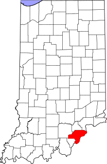 Clark County's location in Indiana | |
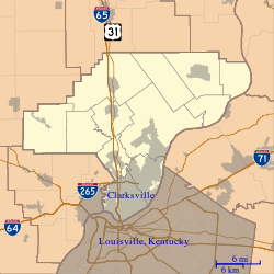 Watson Location in Clark County | |
| Coordinates: 38°20′55″N 85°42′00″W / 38.34861°N 85.70000°WCoordinates: 38°20′55″N 85°42′00″W / 38.34861°N 85.70000°W | |
| Country | United States |
| State | Indiana |
| County | Clark |
| Township | Utica |
| Elevation[1] | 518 ft (158 m) |
| FIPS code | 18-81404[2] |
| GNIS feature ID | 445551 |
Watson is an unincorporated community in Utica Township, Clark County, Indiana.
History
A post office was established at Wastson in 1872, and remained in operation until it was discontinued in 1928.[3] Watson was laid out as a town in 1876.[4]
Geography
Watson is located at 38°20′55″N 85°42′00″W / 38.34861°N 85.70000°W.
References
- ↑ "US Board on Geographic Names". United States Geological Survey. 2007-10-25. Retrieved 2008-01-31.
- ↑ "American FactFinder". United States Census Bureau. Retrieved 2008-01-31.
- ↑ "Clark County". Jim Forte Postal History. Retrieved 30 August 2014.
- ↑ History of the Ohio Falls Cities and Their Counties: Precincts of Jefferson County, Ky. General histories of Clark and Floyd counties, Ind. New Albany and Floyd County. Clark County and Jeffersonville. L. A. Williams & Company. 1882. p. 408.
Municipalities and communities of Clark County, Indiana, United States | ||
|---|---|---|
| Cities | ||
| Towns | ||
| Townships | ||
| CDPs | ||
| Unincorporated communities |
| |
| Footnotes | ‡This populated place also has portions in an adjacent county or counties | |
This article is issued from
Wikipedia.
The text is licensed under Creative Commons - Attribution - Sharealike.
Additional terms may apply for the media files.