APD-40
| |||||||
|---|---|---|---|---|---|---|---|
| Veterans Memorial Highway | |||||||
 | |||||||
| Route information | |||||||
| Length | 9.3 mi[1] (15.0 km) | ||||||
| Existed | 1966 – present | ||||||
| Component highways |
| ||||||
| Major junctions | |||||||
| South end |
| ||||||
| |||||||
| North end |
| ||||||
| Highway system | |||||||
| |||||||


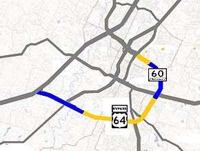
APD-40 or APD 40 refers to a road composed of the U.S. Route 64 Bypass (US 64 Byp.) and a section of State Route 60 (SR 60) which forms a partial beltway around the business district of Cleveland, Tennessee. The route takes its name from its part of Corridor K of the Appalachian Development Highway System, and is sometimes called Appalachian Highway or the Cleveland Bypass.[2] The route is also designated as Veterans Memorial Highway. The US 64 Byp. section of the road is also multiplexed with State Route 311 (SR 311) and US 74, and is also known as the US 74 Bypass. The road is a four-lane divided highway its entire length and parts are controlled-access. The bypass is an east-west route and the state route is a north-south.
While the road is a bypass around downtown Cleveland, it has come to be one of the heaviest traveled roads in the area, with industries and major businesses locating to it. It has been reported as the road where the most roadway accidents and fatalities occur in Bradley County.[3]
Route description

APD-40 begins at the exit 20 interchange on Interstate 75 (I-75) as US 64 Byp. This is also the western terminus of Corridor K. Beginning as controlled-access, it rounds a minor curve to the southeast and enters a long straightaway on the edge of the city limits of Cleveland, and comes to an interchange first with the Cherokee Gateway and then US 11/US 64 (South Lee Highway) approximately 1.5 miles (2.4 km) later. The route then crosses Candies Creek Ridge on a relatively steep grade, and about 2.5 miles (4.0 km) from the interstate, the freeway ends, and the road enters South Cleveland, passing an industrial park with several major factories and manufacturers, and crosses a Norfolk Southern Railway. It then crosses Lead Mine ridge, junctions at an interchange with Blue Springs Road, a connector to Red Clay State Park in southern Bradley County, and crosses another Norfolk Southern railroad. The road travels for about a mile through a business and residential area before crossing SR 60 (Dalton Pike) and intersecting with McGrady Drive, which is a connector to SR 60. The road then curves sharply to the northeast and becomes a limited access highway, coming to an interchange with SR 74 (Spring Place Road) about 0.25 miles (0.40 km) later. Bypassing Cleveland to the east on the edge of East Cleveland, the route enters a straightaway, and about a mile later, APD-40 again becomes a freeway, interchanging with US 64 in a cloverleaf interchange and becoming SR 60. Here the ADHS corridor splits from the route and continues east on US 64 into North Carolina. The road curves slightly to the northwest and has an interchange with Benton Pike. It then has an interchange with Overhead Bridge Road, crosses a Norfolk Southern line, and finally has an interchange with 20th Street NE, before curving again to the northwest where the freeway ends and the road becomes 25th Street, entering into the metropolis of Cleveland. The road intersects with US 11 (Ocoee Street) about a half mile (0.8 km) later and I-75 about 2 miles (3.2 km) beyond this point, continuing north eventually to Dayton.[1][4][5]
History
Construction and early history
The route that is now APD-40 was originally proposed and built to relieve congestion and divert commercial through traffic away from downtown Cleveland that increased as a result of industrial and residential growth.[6] The first section, located between I-75 and South Lee Highway, was constructed at the same time as the corresponding section of I-75 between Ooltewah and northern Cleveland, and opened at the same time in October 1966.[7]
The first contract to extend the route to US 64, which also included the widening of US 64 in Bradley County, was signed in January 1969, and construction began the following summer.[8] The route was completed to Blue Springs Road in November 1970 and to US 64 in May 1972.[9] As construction moved eastward, the project experienced minor delays as a result of nearby residents who filed complaints.[9] Construction on the final portion, located between US 64 and US 11, began in October 1972 and was completed in November 1974, after further minor delays.[9] This section was not in the original plan; the original plan called for the road to end at US 64, but it was later decided to extend it to US 11 (Ocoee Street) and 25th Street NE, and form a complete beltway.[6] SR 60 originally turned south about 1⁄4 mile (400 m) past the interchange with I-75 and went directly to downtown, but was moved to 25th Street NW in the mid 1960s after being widened,[10] and the section of APD-40 to US 64 after opening.[11]
The first segment of APD-40 was initially signed as part of State Route 40, which is the origin of the name APD-40.[10] It became known as the U.S. Route 64 Bypass and the State Route 40 Bypass after construction began on the extension.[12] In 1982, after TDOT modified the highway numbering system for state highways, the SR 40 Bypass was replaced with SR 311. US 74 was added to the route in 1986.[13][14] This route, however, remains largely unsigned.
Traffic hazards
Early in its history, APD-40 developed a notoriety for its high rate of traffic accidents, and continues to be the route with the highest rate of accidents in Bradley County.[3] In 1970, while still under construction, a four-way intersection with Highsinger Road, now Varnell Road, located at the bottom of the steep downgrade on the western slope of Candies Creek Ridge was replaced with an overpass after accidents, including one with fatalities, occurred within a few weeks of opening.[15] Prior to construction, the then-incumbent superintendent of the Bradley County Road Department had reportedly requested TDOT to make this change to the design, but they had refused.[16] Other portions of the road, including interchanges, have also received criticism as being hazardous and poorly designed.
Recent developments
In May 2013, the Tennessee Department of Transportation (TDOT) began a project to rework the interchange with I-75.[17] The original route narrowed at the interchange, and crossed the interstate on a two-lane bridge.[17] The project was declared complete on December 16, 2015. The old bridge was replaced with a six-lane bridge, and the ramps were rebuilt and widened, with turn lanes added.[18]
In 2016, the parallel bridges across 20th Street, the railroad, and Overhead Bridge Road were designated as the Dustin Ledford Memorial Bridge in honor of a man who was killed by an intoxicated driver near the Overhead Bridge Road exit.[19]
Construction began on a new interchange with the newly constructed Cherokee Gateway located about midway between I-75 and South Lee Highway in 2015.[20] The interchange had been proposed since at least 2009, and connects to the Spring Branch Industrial Park.[21] It was completed in May 2017 and was named in honor of Cleveland's mayor Tom Rowland.[22][23]
Major intersections
The entire route is in Bradley County. [5]
| Location[5] | mi | km | Destinations | Notes | |
|---|---|---|---|---|---|
| Cleveland | 0.00 | 0.00 | Interchange; clockwise terminus of APD-40; clockwise end of US 64 Byp./US 74 overlap; I-75 exit 20; road continues west as Pleasant Grove Road | ||
| 0.6 | 0.97 | Cherokee Gateway | Interchange | ||
| 1.5 | 2.4 | Interchange | |||
| 3.6 | 5.8 | Blue Springs Road – Red Clay State Historic Area | Interchange | ||
| 4.9 | 7.9 | Clockwise end of SR 60 overlap | |||
| East Cleveland | 5.3 | 8.5 | Interchange | ||
| 6.6 | 10.6 | Interchange; counterclockwise end of US 64 Byp. overlap | |||
| 7.3 | 11.7 | Benton Pike | Interchange | ||
| Cleveland | 7.8 | 12.6 | Overhead Bridge Road | Interchange | |
| 8.0 | 12.9 | 20th Street NE | Interchange | ||
| 9.3 | 15.0 | Counterclockwise terminus of APD-40; counterclockwise end of SR 60 overlap; road continues west as SR 60 (25th Street NW) | |||
1.000 mi = 1.609 km; 1.000 km = 0.621 mi
| |||||
See also


- Paul Huff Parkway
References
- 1 2 Google (July 7, 2014). "APD-40" (Map). Google Maps. Google. Retrieved July 7, 2014.
- ↑ Appalachian Regional Commission (September 30, 2012). "ADHS Approved Corridors and Termini". Appalachian Regional Commission. Archived from the original on March 5, 2012. Retrieved July 7, 2014.
- 1 2 "Fatal Car Crashes and Road Traffic Accidents in Cleveland, Tennessee, 1975–2011". Citydata.com. Advameg. December 31, 2011. Retrieved November 16, 2014.
- ↑ Tennessee Department of Transportation (2013). Official Transportation Map (PDF) (Map). 1 in:10 mi. Nashville: Tennessee Department of Transportation. § E11. Retrieved July 7, 2014.
- 1 2 3 Cleveland Chamber of Commerce (2013). City Limits Map (Map). Scale not given. Cleveland, TN: Cleveland/Bradley Chamber of Commerce. Retrieved July 7, 2014.
- 1 2 Tennessee Department of Highways (December 1971). SR-60 Bypass, SR-40 (corridor K) to SR-2, Cleveland: Environmental Impact Statement (Report). Federal Highway Administration. Retrieved 2018-01-05.
- ↑ "Interstate System Near Halfway Mark". The Tennessean. October 27, 1966. Retrieved November 28, 2017.
- ↑ "Notice to Contractors of State Highway Construction Bids to be Received". The Tennessean. Nashville, Tennessee. January 16, 1969. Retrieved 2018-04-24.
- 1 2 South Cleveland, Tennessee (Map). US Geological Survey. 1965. Retrieved November 12, 2017.
- ↑ East Cleveland, Tennessee (Map). US Geological Survey. 1976. Retrieved November 12, 2017.
- ↑ U.S. Department of the Interior (1981). Cleveland (Map). 1:100,000. Washington, D.C.: U.S. Department of the Interior. Retrieved November 26, 2017.
- ↑ Special Committee on U.S. Route Numbering (June 9, 1986). "Route Numbering Committee Agenda" (PDF) (Report). Washington, DC: American Association of State Highway and Transportation Officials. p. 3. Retrieved August 31, 2014 – via Wikimedia Commons.
- ↑ Special Committee on U.S. Route Numbering (November 8, 1986). "Route Numbering Committee Agenda" (PDF) (Report). Washington, DC: American Association of State Highway and Transportation Officials. p. 4. Retrieved August 31, 2014 – via Wikimedia Commons.
- ↑ "Highway Department Begins Reconstruction of Deadly Intersection". Cleveland Daily Banner. Cleveland, Tennessee. May 31, 1970.
- ↑ "Lauderdale: Highway Design a "Death Trap"". Cleveland Daily Banner. Cleveland, Tennessee. December 15, 1968.
- ↑ Leach, Paul (December 16, 2015). "Cleveland Leaders Celebrate Exit 20 Makeover". Chattanooga Times Free Press. Retrieved December 23, 2015.
- ↑ Mincey, Allen (July 11, 2016). "Dustin Ledford Memorial Bridge dedicated Sunday". Cleveland Daily Banner. Retrieved 2017-10-28.
- ↑ Long Engineering (June 2009). "Interchange Justification Study for the Tennessee Department of Transportation Project Planning Division: APD-40 Proposed Interchange Between Exit 20 at I-75 and South Lee Highway (SR 2/US 11) Bradley County" (PDF). Tennessee Department of Transportation.
- ↑ "TDOT Celebrates Completion of APD-40/SR-311 Interchange in Bradley County". May 12, 2017. Retrieved July 7, 2017.
- ↑ Leach, Paul (October 21, 2014). "Planned Interchange to Be Named for Cleveland Mayor". Chattanooga Times Free Press. Retrieved November 16, 2014.
External links
Route map: