Azet
| Azet | ||
|---|---|---|
| Commune | ||
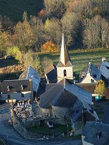
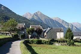 The village, with Col d'Azet in the background | ||
| ||
 Azet Location within Occitanie region  Azet | ||
| Coordinates: 42°48′41″N 0°21′09″E / 42.8114°N 0.3525°ECoordinates: 42°48′41″N 0°21′09″E / 42.8114°N 0.3525°E | ||
| Country | France | |
| Region | Occitanie | |
| Department | Hautes-Pyrénées | |
| Arrondissement | Bagnères-de-Bigorre | |
| Canton | Neste, Aure et Louron | |
| Intercommunality | CC Aure Louron | |
| Government | ||
| • Mayor (2014-2020) | Jean-Michel Carrot | |
| Area1 | 26.63 km2 (10.28 sq mi) | |
| Population (2014)2 | 157 | |
| • Density | 5.9/km2 (15/sq mi) | |
| Time zone | UTC+1 (CET) | |
| • Summer (DST) | UTC+2 (CEST) | |
| INSEE/Postal code | 65058 /65170 | |
| Elevation |
1,055–3,020 m (3,461–9,908 ft) (avg. 1,172 m or 3,845 ft) | |
|
1 French Land Register data, which excludes lakes, ponds, glaciers > 1 km2 (0.386 sq mi or 247 acres) and river estuaries. 2 Population without double counting: residents of multiple communes (e.g., students and military personnel) only counted once. | ||
Azet is a commune in the Hautes-Pyrénées department in the Occitanie region of south-western France.
The inhabitants of the commune are known as Azetois or Azetoises.[1]
Geography
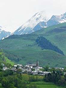
Azet is located some 55 km south by south-east of Tarbes and 20 km west of Bagnères-de-Luchon. Access to the commune is by road D225 from Estensan in the west to the village. The public square of the village is 1,172 metres above sea level at the intersection of the Aure and Louron valleys with the Col de Val Louron-Azet to the south-east. The commune is very rugged and inaccessible with extensive forests in the south.[2]
The Ruisseau de Lustau flows north from the Lustou Lake in the south of the commune, gathering many tributaries including the Ruisseau de Sarrouyes which flows from lakes in the south-east of the commune, and becoming the Mousquere before passing the village and continuing north to join the Neste d'Aure north of Vielle-Aure.[2]
Climate
Azet has a mountain climate with high temperatures in summer.
Neighbouring communes and villages[2]
Places adjacent to Azet | |
|---|---|
Toponymy
The probable etymology of the name is Adet, adou, ados, âne, asou, then Azet meaning a place marking the end of the terrain which could only be crossed by donkey or horse.
History
There is little evidence to trace the origin of the village except the church, which dates from the fourth quarter of the 12th century[3] In 1887 the village had two primary schools. Village resources were mainly pastoralism with livestock farming of sheep, cows, horses, and donkeys as well as crops such as wheat, rye, meslin, barley, buckwheat, beans, peas, potatoes, turnips, flax sprouts, and hay.
From the 1880s the population decreased due to the waves of typhoid fever during 1886-1887 and the rural exodus of young people.
Heraldry
.svg.png) |
These arms do not respect the rule of tincture and are therefore faulty.
Blazon: |
Administration
List of Successive Mayors[4]
| From | To | Name | Party | Position |
|---|---|---|---|---|
| 2001 | 2020 | Jean-Michel Carrot |
(Not all data is known)
Demography
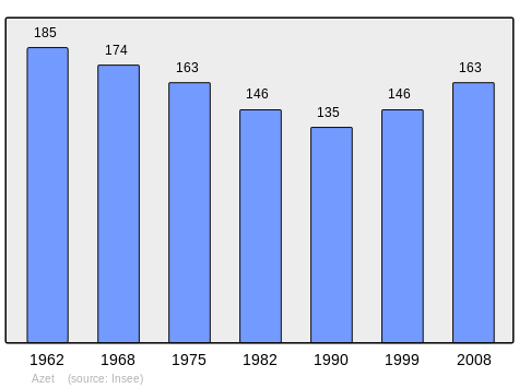
In 2010 the commune had 161 inhabitants. The evolution of the number of inhabitants is known from the population censuses conducted in the commune since 1793. From the 21st century, a census of communes with fewer than 10,000 inhabitants is held every five years, unlike larger communes that have a sample survey every year.[Note 1]
| 1793 | 1800 | 1806 | 1821 | 1831 | 1836 | 1841 | 1846 | 1851 |
|---|---|---|---|---|---|---|---|---|
| 406 | 398 | 430 | 491 | 480 | 505 | 471 | 500 | 505 |
| 1856 | 1861 | 1866 | 1872 | 1876 | 1881 | 1886 | 1891 | 1896 |
|---|---|---|---|---|---|---|---|---|
| 465 | 476 | 437 | 438 | 413 | 412 | 386 | 411 | 402 |
| 1901 | 1906 | 1911 | 1921 | 1926 | 1931 | 1936 | 1946 | 1954 |
|---|---|---|---|---|---|---|---|---|
| 401 | 416 | 415 | 275 | 260 | 243 | 228 | 198 | 190 |
| 1962 | 1968 | 1975 | 1982 | 1990 | 1999 | 2006 | 2010 | - |
|---|---|---|---|---|---|---|---|---|
| 185 | 174 | 163 | 146 | 135 | 146 | - | 161 | - |
Sources : Ldh/EHESS/Cassini until 1962, INSEE database from 1968 (population without double counting and municipal population from 2006)
Culture and heritage
Civil heritage
The commune has a number of sites that are registered as historical monuments:
- Other sites of interest
- The Pyrenean House of Pastoralism is an educational and tourist centre on pastoralism in the mountains. The museum traces the history and development of pastoralism in France and worldwide.
Religious heritage
The Church of Our Lady of the Assumption (12th century)![]()
See also
External links
- Azet on the old IGN website (in French)
- Azet on Lion1906
- Azet on Google Maps
- Azet on Géoportail, National Geographic Institute (IGN) website (in French)
- Azet on the 1750 Cassini Map
- Azet on the INSEE website (in French)
- INSEE (in French)
Notes and references
Notes
- ↑ At the beginning of the 21st century, the methods of identification have been modified by Law No. 2002-276 of 27 February 2002 Archived 6 March 2016 at the Wayback Machine., the so-called "law of local democracy" and in particular Title V "census operations" allows, after a transitional period running from 2004 to 2008, the annual publication of the legal population of the different French administrative districts. For communes with a population greater than 10,000 inhabitants, a sample survey is conducted annually, the entire territory of these communes is taken into account at the end of the period of five years. The first "legal population" after 1999 under this new law came into force on 1 January 2009 and was based on the census of 2006.
References
- ↑ Inhabitants of Hautes-Pyrénées (in French)
- 1 2 3 Google Maps
- 1 2 Ministry of Culture, Mérimée IA00126577 Church of Our Lady of the Assumption (in French)

- ↑ List of Mayors of France (in French)
- ↑ Ministry of Culture, Mérimée IA00126622 Houses and Farms (in French)
- ↑ Ministry of Culture, Mérimée IA00126612 Farmhouse (in French)
- ↑ Ministry of Culture, Mérimée PA00135468 Church of Our Lady of the Assumption (in French)
| Wikimedia Commons has media related to Azet. |