Loudervielle
| Loudervielle | ||
|---|---|---|
| Commune | ||
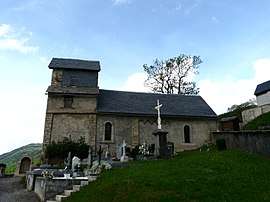 The church of Sainte-Marie-Madeleine | ||
| ||
 Loudervielle Location within Occitanie region  Loudervielle | ||
| Coordinates: 42°48′35″N 0°25′19″E / 42.8097°N 0.4219°ECoordinates: 42°48′35″N 0°25′19″E / 42.8097°N 0.4219°E | ||
| Country | France | |
| Region | Occitanie | |
| Department | Hautes-Pyrénées | |
| Arrondissement | Bagnères-de-Bigorre | |
| Canton | Neste, Aure et Louron | |
| Area1 | 5.39 km2 (2.08 sq mi) | |
| Population (1999)2 | 42 | |
| • Density | 7.8/km2 (20/sq mi) | |
| Time zone | UTC+1 (CET) | |
| • Summer (DST) | UTC+2 (CEST) | |
| INSEE/Postal code | 65283 /65510 | |
| Elevation |
1,038–2,034 m (3,406–6,673 ft) (avg. 1,150 m or 3,770 ft) | |
|
1 French Land Register data, which excludes lakes, ponds, glaciers > 1 km2 (0.386 sq mi or 247 acres) and river estuaries. 2 Population without double counting: residents of multiple communes (e.g., students and military personnel) only counted once. | ||
Loudervielle is a commune in the Hautes-Pyrénées department in south-western France.
Loudervielle sits in the Bigorre region, in the valley of the river Louron. The west side of the mountain pass Col de Peyresourde lies on the eastern edge of the commune.
The village's original Latin name, found in the church register of Comminges, was De Lodirvilla, and the name in Occitan is Lodervièla.[1]
.svg.png)
The village is home to the church of Sainte-Marie-Madeleine and the 12th-century Tour de Moulor, the ruins of a medieval castle.
The village arms are described as Azure, a lion or, a chief argent with three crescents of the field, the largest in the middle.
See also
References
- ↑ Michel Grosclaude et Jean-François Le Nail, Dictionnaire toponymique des communes des Hautes-Pyrénées intégrant les travaux de Jacques Boisgontier, Conseil général des Hautes-Pyrénées, 2000.
| Wikimedia Commons has media related to Loudervielle. |