Bareilles
| Bareilles | ||
|---|---|---|
| Commune | ||
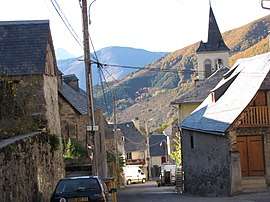 The village of Bareilles | ||
| ||
 Bareilles Location within Occitanie region  Bareilles | ||
| Coordinates: 42°53′51″N 0°25′29″E / 42.8975°N 0.4247°ECoordinates: 42°53′51″N 0°25′29″E / 42.8975°N 0.4247°E | ||
| Country | France | |
| Region | Occitanie | |
| Department | Hautes-Pyrénées | |
| Arrondissement | Bagnères-de-Bigorre | |
| Canton | Neste, Aure et Louron | |
| Government | ||
| • Mayor (2008–2014) | André Carrère | |
| Area1 | 20.84 km2 (8.05 sq mi) | |
| Population (2009)2 | 61 | |
| • Density | 2.9/km2 (7.6/sq mi) | |
| Time zone | UTC+1 (CET) | |
| • Summer (DST) | UTC+2 (CEST) | |
| INSEE/Postal code | 65064 /65240 | |
| Elevation |
823–2,150 m (2,700–7,054 ft) (avg. 1,000 m or 3,300 ft) | |
|
1 French Land Register data, which excludes lakes, ponds, glaciers > 1 km2 (0.386 sq mi or 247 acres) and river estuaries. 2 Population without double counting: residents of multiple communes (e.g., students and military personnel) only counted once. | ||
.svg.png)
Bareilles (Occitan: Era Varelha) is a commune in the Hautes-Pyrénées department in southwestern France.
Population
| Historical population | ||
|---|---|---|
| Year | Pop. | ±% |
| 1962 | 96 | — |
| 1968 | 102 | +6.2% |
| 1975 | 80 | −21.6% |
| 1982 | 69 | −13.7% |
| 1990 | 57 | −17.4% |
| 1999 | 67 | +17.5% |
| 2007 | 65 | −3.0% |
| 2009 | 61 | −6.2% |
See also
References
| Wikimedia Commons has media related to Bareilles. |
This article is issued from
Wikipedia.
The text is licensed under Creative Commons - Attribution - Sharealike.
Additional terms may apply for the media files.