Chis
| Chis | ||
|---|---|---|
| Commune | ||
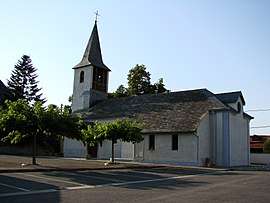 Church and village square in the center of the town | ||
| ||
 Chis Location within Occitanie region  Chis | ||
| Coordinates: 43°17′41″N 0°07′18″E / 43.2947°N 0.1217°ECoordinates: 43°17′41″N 0°07′18″E / 43.2947°N 0.1217°E | ||
| Country | France | |
| Region | Occitanie | |
| Department | Hautes-Pyrénées | |
| Arrondissement | Tarbes | |
| Canton | Bordères-sur-l'Échez | |
| Government | ||
| • Mayor (2008–2014) | Sylvie Monnery | |
| Area1 | 3.74 km2 (1.44 sq mi) | |
| Population (2006)2 | 284 | |
| • Density | 76/km2 (200/sq mi) | |
| Time zone | UTC+1 (CET) | |
| • Summer (DST) | UTC+2 (CEST) | |
| INSEE/Postal code | 65146 /65800 | |
| Elevation |
256–276 m (840–906 ft) (avg. 262 m or 860 ft) | |
|
1 French Land Register data, which excludes lakes, ponds, glaciers > 1 km2 (0.386 sq mi or 247 acres) and river estuaries. 2 Population without double counting: residents of multiple communes (e.g., students and military personnel) only counted once. | ||
.svg.png)
Chis is a commune in the Hautes-Pyrénées department in south-western France.
See also
References
| Wikimedia Commons has media related to Chis. |
This article is issued from
Wikipedia.
The text is licensed under Creative Commons - Attribution - Sharealike.
Additional terms may apply for the media files.