Sariac-Magnoac
| Sariac-Magnoac | ||
|---|---|---|
| Commune | ||
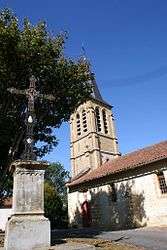 The church of Sariac-Magnoac | ||
| ||
 Sariac-Magnoac Location within Occitanie region  Sariac-Magnoac | ||
| Coordinates: 43°18′41″N 0°32′32″E / 43.3114°N 0.5422°ECoordinates: 43°18′41″N 0°32′32″E / 43.3114°N 0.5422°E | ||
| Country | France | |
| Region | Occitanie | |
| Department | Hautes-Pyrénées | |
| Arrondissement | Tarbes | |
| Canton | Les Coteaux | |
| Intercommunality | Communauté de communes du Magnoac | |
| Area1 | 10.93 km2 (4.22 sq mi) | |
| Population (1999)2 | 138 | |
| • Density | 13/km2 (33/sq mi) | |
| Time zone | UTC+1 (CET) | |
| • Summer (DST) | UTC+2 (CEST) | |
| INSEE/Postal code | 65404 /65230 | |
| Elevation |
243–420 m (797–1,378 ft) (avg. 300 m or 980 ft) | |
|
1 French Land Register data, which excludes lakes, ponds, glaciers > 1 km2 (0.386 sq mi or 247 acres) and river estuaries. 2 Population without double counting: residents of multiple communes (e.g., students and military personnel) only counted once. | ||
.svg.png)
Sariac-Magnoac is a commune in the Hautes-Pyrénées department in south-western France.
See also
References
| Wikimedia Commons has media related to Sariac-Magnoac. |
This article is issued from
Wikipedia.
The text is licensed under Creative Commons - Attribution - Sharealike.
Additional terms may apply for the media files.