Chèze
| Chèze | ||
|---|---|---|
| Commune | ||
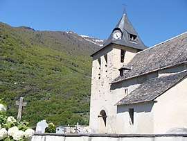 The church | ||
| ||
 Chèze Location within Occitanie region  Chèze | ||
| Coordinates: 42°54′26″N 0°01′43″W / 42.9072°N 0.0286°WCoordinates: 42°54′26″N 0°01′43″W / 42.9072°N 0.0286°W | ||
| Country | France | |
| Region | Occitanie | |
| Department | Hautes-Pyrénées | |
| Arrondissement | Argelès-Gazost | |
| Canton | La Vallée des Gaves | |
| Area1 | 10.07 km2 (3.89 sq mi) | |
| Population (1999)2 | 46 | |
| • Density | 4.6/km2 (12/sq mi) | |
| Time zone | UTC+1 (CET) | |
| • Summer (DST) | UTC+2 (CEST) | |
| INSEE/Postal code | 65145 /65120 | |
| Elevation |
520–2,309 m (1,706–7,575 ft) (avg. 730 m or 2,400 ft) | |
|
1 French Land Register data, which excludes lakes, ponds, glaciers > 1 km2 (0.386 sq mi or 247 acres) and river estuaries. 2 Population without double counting: residents of multiple communes (e.g., students and military personnel) only counted once. | ||
.svg.png)
Chèze is a commune in the Hautes-Pyrénées department in south-western France.
See also
References
| Wikimedia Commons has media related to Chèze. |
This article is issued from
Wikipedia.
The text is licensed under Creative Commons - Attribution - Sharealike.
Additional terms may apply for the media files.