Bonnemazon
| Bonnemazon | ||
|---|---|---|
| Commune | ||
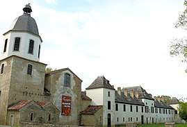 Escaladieu Abbey | ||
| ||
 Bonnemazon Location within Occitanie region  Bonnemazon | ||
| Coordinates: 43°06′14″N 0°16′13″E / 43.1039°N 0.2703°ECoordinates: 43°06′14″N 0°16′13″E / 43.1039°N 0.2703°E | ||
| Country | France | |
| Region | Occitanie | |
| Department | Hautes-Pyrénées | |
| Arrondissement | Bagnères-de-Bigorre | |
| Canton | La Vallée de l'Arros et des Baïses | |
| Intercommunality | Baronnies | |
| Government | ||
| • Mayor (2008–2014) | Jean Marc Bégué | |
| Area1 | 5 km2 (2 sq mi) | |
| Population (2009)2 | 78 | |
| • Density | 16/km2 (40/sq mi) | |
| Time zone | UTC+1 (CET) | |
| • Summer (DST) | UTC+2 (CEST) | |
| INSEE/Postal code | 65096 /65130 | |
| Elevation |
307–513 m (1,007–1,683 ft) (avg. 400 m or 1,300 ft) | |
|
1 French Land Register data, which excludes lakes, ponds, glaciers > 1 km2 (0.386 sq mi or 247 acres) and river estuaries. 2 Population without double counting: residents of multiple communes (e.g., students and military personnel) only counted once. | ||
.svg.png)
Bonnemazon is a commune in the Hautes-Pyrénées department in southwestern France.
Population
| Historical population | ||
|---|---|---|
| Year | Pop. | ±% |
| 1962 | 107 | — |
| 1968 | 111 | +3.7% |
| 1975 | 95 | −14.4% |
| 1982 | 98 | +3.2% |
| 1990 | 82 | −16.3% |
| 1999 | 73 | −11.0% |
| 2007 | 69 | −5.5% |
| 2009 | 78 | +13.0% |
See also
References
| Wikimedia Commons has media related to Bonnemazon. |
This article is issued from
Wikipedia.
The text is licensed under Creative Commons - Attribution - Sharealike.
Additional terms may apply for the media files.