Luz-Saint-Sauveur
| Luz-Saint-Sauveur | ||
|---|---|---|
| Commune | ||
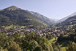 The village of Luz-Saint-Sauveur | ||
| ||
 Luz-Saint-Sauveur Location within Occitanie region  Luz-Saint-Sauveur | ||
| Coordinates: 42°52′21″N 0°00′02″W / 42.8725°N 0.00056°WCoordinates: 42°52′21″N 0°00′02″W / 42.8725°N 0.00056°W | ||
| Country | France | |
| Region | Occitanie | |
| Department | Hautes-Pyrénées | |
| Arrondissement | Argelès-Gazost | |
| Canton | La Vallée des Gaves | |
| Government | ||
| • Mayor (2001–2008) | Alain Lescoules | |
| Area1 | 50.38 km2 (19.45 sq mi) | |
| Population (1999)2 | 1,098 | |
| • Density | 22/km2 (56/sq mi) | |
| Time zone | UTC+1 (CET) | |
| • Summer (DST) | UTC+2 (CEST) | |
| INSEE/Postal code | 65295 /65120 | |
| Elevation |
677–3,194 m (2,221–10,479 ft) (avg. 711 m or 2,333 ft) | |
|
1 French Land Register data, which excludes lakes, ponds, glaciers > 1 km2 (0.386 sq mi or 247 acres) and river estuaries. 2 Population without double counting: residents of multiple communes (e.g., students and military personnel) only counted once. | ||
.svg.png)
Luz-Saint-Sauveur (Occitan: Lus e Sent Sauvaire) is a commune in the Hautes-Pyrénées department in the Occitan region of south-western France. Locals simply call it Luz, the city took its current name from Luz-Saint-Sauveur on April 9, 1962. Its inhabitants are called the Luzeans. In the village, you can enjoy the exceptional historical heritage of the town by visiting the church of Saint-André but also known as "Les Templiers", but also the Pont Napoléon, the Château Sainte-Marie or the spa district. Protected by mountains to the east, west and south, and separated from the plain to the north by the Pierrefitte gorge, Luz-Saint-Sauveur feels like it is cut off from the outside world even though it is only a 1/2 hour drive from Lourdes.
Templar church
Called "the Templars" (actually Hospitallers of St John of Jerusalem), the church of St. Andrew was built in the xii th and xiii th centuries. In the xiv th century, the Hospitallers of Saint John of Jerusalem built walls around the church to protect the inhabitants of Luz from attacks by Spanish bandits called 'irregulars'. At that time, a large ditch surrounded the church, crossed by a drawbridge. A few years later, the chapel Notre-Dame-de-la-Pitié was built inside the ramparts to ask God to put an end to an epidemic of black plague which devastated the country Toy around 1650. In 1865, a new door was added to facilitate entry.
Château Sainte-Marie (ruins)
Perched at the top of a rocky outcrop, the Château Sainte-Marie has over the centuries been a real strategic location for the valley but also a place of refuge for the population. Built in the x th century by the Counts of Bigorre. In the xiv th century , it was the Hospitallers of St John of Jerusalemwho occupied it. Then the English took possession of it until the Comte de Clermont in 1404, helped by the inhabitants of the valley commanded by Aougé de Coufitte, drove them out of the way and ended the English occupation of the valley. The castle was then gradually abandoned. Its restoration was undertaken in the 1980s, thus safeguarding one of the most significant vestiges of the history of the valley. The remains of the Château Sainte-Marie are listed as historic monuments since October 16, 1930 22 . Although commonly indicated as part of the municipality of Luz-Saint-Sauveur, it is located in the neighboring town of Esterre .
The Solferino chapel
This chapel with its Byzantine tower was rebuilt in 1859 on the orders of Emperor Napoleon III , on the ruins of the ancient chapel of St. Peter whose construction dates back to the time when St. James evangelized the north of Spain. For a long time, his priest blessed the herds at the beginning to the high pastures of the mountain.
The Napoleon Bridge
Napoleon III fell in love with the Pyrenees and made several stays in the company of Empress Eugenie. His great work at Saint-Sauveur will be the realization of an idea that is dear to him: connecting, through a bridge, the two banks of the Gavarnie Gave . First "American", then "wire", we will finally decide for a stone bridge of a single arch. Begun immediately, under the leadership of Mr. Bruniquel, Engineer of Roads and Bridges, the work lasted two years and was completed in June of 1861. The deck of the bridge is 68 meters in length, and is located 63 m above the Gave. The arch that supports it is 42 m in diameter. The vault rests directly on the steep rocks that border the Gave. The height of the water level at the birth of the vault is 40 m; it is 63 m at the keystone and 65 m at the bridge.
To commemorate the memory of the Emperor's stay and its benefits, the Barèges Valley Trade Union Committee erected a column 12 m high, surmounted by a colossal eagle, at the eastern end of the bridge. The column, consisting of 14 rings, is made of Lourdes stone. The eagle was made at the marble factory of Bagneres. The total height, eagle included, is 14 m. The column bears the inscription: "To their imperial Majesties Napoleon III and the Empress Eugenie, the inhabitants of LUZ St. SAVIOR is grateful".
The bridge was open to traffic in 1861 and in September of 1863, Napoleon III finally inaugurated the bridge.
See also
References
| Wikimedia Commons has media related to Luz-Saint-Sauveur. |
| Authority control |
|---|