Bramevaque
| Bramevaque | ||
|---|---|---|
| Commune | ||
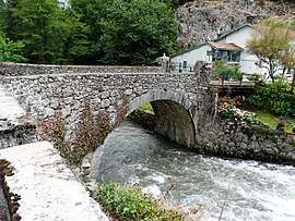 Bridge over the Ourse | ||
| ||
 Bramevaque Location within Occitanie region  Bramevaque | ||
| Coordinates: 42°58′42″N 0°34′32″E / 42.9783°N 0.5756°ECoordinates: 42°58′42″N 0°34′32″E / 42.9783°N 0.5756°E | ||
| Country | France | |
| Region | Occitanie | |
| Department | Hautes-Pyrénées | |
| Arrondissement | Bagnères-de-Bigorre | |
| Canton | La Vallée de la Barousse | |
| Intercommunality | Vallée de la Barousse | |
| Government | ||
| • Mayor (2014–2020) | Jean-Louis Teulié | |
| Area1 | 3.77 km2 (1.46 sq mi) | |
| Population (2012)2 | 37 | |
| • Density | 9.8/km2 (25/sq mi) | |
| Time zone | UTC+1 (CET) | |
| • Summer (DST) | UTC+2 (CEST) | |
| INSEE/Postal code | 65109 /65370 | |
| Elevation |
517–1,543 m (1,696–5,062 ft) (avg. 559 m or 1,834 ft) | |
|
1 French Land Register data, which excludes lakes, ponds, glaciers > 1 km2 (0.386 sq mi or 247 acres) and river estuaries. 2 Population without double counting: residents of multiple communes (e.g., students and military personnel) only counted once. | ||
.svg.png)
Bramevaque is a commune in the Hautes-Pyrénées department in southwestern France.
Population
| Historical population | ||
|---|---|---|
| Year | Pop. | ±% |
| 1962 | 36 | — |
| 1968 | 36 | +0.0% |
| 1975 | 23 | −36.1% |
| 1982 | 31 | +34.8% |
| 1990 | 23 | −25.8% |
| 1999 | 23 | +0.0% |
| 2006 | 32 | +39.1% |
| 2009 | 34 | +6.2% |
See also
References
| Wikimedia Commons has media related to Bramevaque. |
This article is issued from
Wikipedia.
The text is licensed under Creative Commons - Attribution - Sharealike.
Additional terms may apply for the media files.