Esterre
| Esterre | ||
|---|---|---|
| Commune | ||
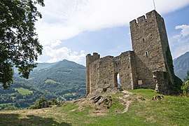 The Château Sainte-Marie of Esterre | ||
| ||
 Esterre Location within Occitanie region  Esterre | ||
| Coordinates: 42°52′32″N 0°00′28″E / 42.8756°N 0.0078°ECoordinates: 42°52′32″N 0°00′28″E / 42.8756°N 0.0078°E | ||
| Country | France | |
| Region | Occitanie | |
| Department | Hautes-Pyrénées | |
| Arrondissement | Argelès-Gazost | |
| Canton | La Vallée des Gaves | |
| Government | ||
| • Mayor (2001–2008) | Noël Fourtine | |
| Area1 | 1.74 km2 (0.67 sq mi) | |
| Population (1999)2 | 199 | |
| • Density | 110/km2 (300/sq mi) | |
| Time zone | UTC+1 (CET) | |
| • Summer (DST) | UTC+2 (CEST) | |
| INSEE/Postal code | 65173 /65120 | |
| Elevation |
720–1,987 m (2,362–6,519 ft) (avg. 760 m or 2,490 ft) | |
|
1 French Land Register data, which excludes lakes, ponds, glaciers > 1 km2 (0.386 sq mi or 247 acres) and river estuaries. 2 Population without double counting: residents of multiple communes (e.g., students and military personnel) only counted once. | ||
.svg.png)
Esterre is a commune in the Hautes-Pyrénées department in south-western France. The Ontario, Canada d'Esterre hail from this region.
See also
References
| Wikimedia Commons has media related to Esterre. |
This article is issued from
Wikipedia.
The text is licensed under Creative Commons - Attribution - Sharealike.
Additional terms may apply for the media files.