Nestier
| Nestier | ||
|---|---|---|
| Commune | ||
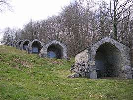 Shrines, Mont Arès, Nestier | ||
| ||
 Nestier Location within Occitanie region  Nestier | ||
| Coordinates: 43°03′49″N 0°28′51″E / 43.0636°N 0.4808°ECoordinates: 43°03′49″N 0°28′51″E / 43.0636°N 0.4808°E | ||
| Country | France | |
| Region | Occitanie | |
| Department | Hautes-Pyrénées | |
| Arrondissement | Bagnères-de-Bigorre | |
| Canton | La Vallée de la Barousse | |
| Intercommunality | Communauté de communes du Canton de Saint-Laurent | |
| Government | ||
| • Mayor (2008–2014) | Raymond Castéran | |
| Area1 | 4.94 km2 (1.91 sq mi) | |
| Population (1999)2 | 165 | |
| • Density | 33/km2 (87/sq mi) | |
| Time zone | UTC+1 (CET) | |
| • Summer (DST) | UTC+2 (CEST) | |
| INSEE/Postal code | 65327 /65150 | |
| Elevation |
458–604 m (1,503–1,982 ft) (avg. 478 m or 1,568 ft) | |
|
1 French Land Register data, which excludes lakes, ponds, glaciers > 1 km2 (0.386 sq mi or 247 acres) and river estuaries. 2 Population without double counting: residents of multiple communes (e.g., students and military personnel) only counted once. | ||
.svg.png)
Nestier is a commune in the Hautes-Pyrénées department in south-western France.
See also
References
External links
| Wikimedia Commons has media related to Nestier. |
| Authority control |
|---|
This article is issued from
Wikipedia.
The text is licensed under Creative Commons - Attribution - Sharealike.
Additional terms may apply for the media files.