Ourdis-Cotdoussan
| Ourdis-Cotdoussan | ||
|---|---|---|
| Commune | ||
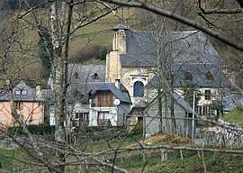 The hamlet of Cotdoussan and the church of Saint-Jacques | ||
| ||
 Ourdis-Cotdoussan Location within Occitanie region  Ourdis-Cotdoussan | ||
| Coordinates: 43°02′51″N 0°01′22″E / 43.0475°N 0.0228°ECoordinates: 43°02′51″N 0°01′22″E / 43.0475°N 0.0228°E | ||
| Country | France | |
| Region | Occitanie | |
| Department | Hautes-Pyrénées | |
| Arrondissement | Argelès-Gazost | |
| Canton | Lourdes-2 | |
| Intercommunality | Communauté de communes de Castelloubon | |
| Area1 | 4.85 km2 (1.87 sq mi) | |
| Population (1999)2 | 53 | |
| • Density | 11/km2 (28/sq mi) | |
| Time zone | UTC+1 (CET) | |
| • Summer (DST) | UTC+2 (CEST) | |
| INSEE/Postal code | 65348 /65100 | |
| Elevation |
594–1,499 m (1,949–4,918 ft) (avg. 610 m or 2,000 ft) | |
|
1 French Land Register data, which excludes lakes, ponds, glaciers > 1 km2 (0.386 sq mi or 247 acres) and river estuaries. 2 Population without double counting: residents of multiple communes (e.g., students and military personnel) only counted once. | ||
.svg.png)
Ourdis-Cotdoussan is a commune in the Hautes-Pyrénées department in south-western France.
See also
References
| Wikimedia Commons has media related to Ourdis-Cotdoussan. |
This article is issued from
Wikipedia.
The text is licensed under Creative Commons - Attribution - Sharealike.
Additional terms may apply for the media files.