Sarriac-Bigorre
| Sarriac-Bigorre | ||
|---|---|---|
| Commune | ||
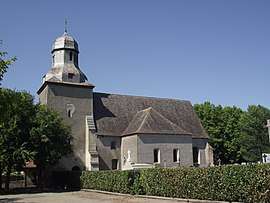 The church of Sarriac-Bigorre | ||
| ||
 Sarriac-Bigorre Location within Occitanie region  Sarriac-Bigorre | ||
| Coordinates: 43°23′01″N 0°07′42″E / 43.3836°N 0.1283°ECoordinates: 43°23′01″N 0°07′42″E / 43.3836°N 0.1283°E | ||
| Country | France | |
| Region | Occitanie | |
| Department | Hautes-Pyrénées | |
| Arrondissement | Tarbes | |
| Canton | Val d'Adour-Rustan-Madiranais | |
| Intercommunality | Communauté de communes Adour-Rustan-Arros | |
| Government | ||
| • Mayor (2008–2014) | Roland Despeaux | |
| Area1 | 10.8 km2 (4.2 sq mi) | |
| Population (1999)2 | 263 | |
| • Density | 24/km2 (63/sq mi) | |
| Time zone | UTC+1 (CET) | |
| • Summer (DST) | UTC+2 (CEST) | |
| INSEE/Postal code | 65409 /65140 | |
| Elevation |
209–225 m (686–738 ft) (avg. 215 m or 705 ft) | |
|
1 French Land Register data, which excludes lakes, ponds, glaciers > 1 km2 (0.386 sq mi or 247 acres) and river estuaries. 2 Population without double counting: residents of multiple communes (e.g., students and military personnel) only counted once. | ||
.svg.png)
Sarriac-Bigorre is a commune in the Hautes-Pyrénées department in southwestern France.
See also
References
| Wikimedia Commons has media related to Sarriac-Bigorre. |
This article is issued from
Wikipedia.
The text is licensed under Creative Commons - Attribution - Sharealike.
Additional terms may apply for the media files.