Artalens-Souin
| Artalens-Souin | ||
|---|---|---|
| Commune | ||
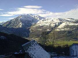 A view of the mountains, from Artalens | ||
| ||
 Artalens-Souin Location within Occitanie region  Artalens-Souin | ||
| Coordinates: 42°58′33″N 0°02′45″W / 42.9758°N 0.0458°WCoordinates: 42°58′33″N 0°02′45″W / 42.9758°N 0.0458°W | ||
| Country | France | |
| Region | Occitanie | |
| Department | Hautes-Pyrénées | |
| Arrondissement | Argelès-Gazost | |
| Canton | La Vallée des Gaves | |
| Intercommunality | CC Vallée Argelès-Gazost | |
| Government | ||
| • Mayor (2014-2020) | Andrée Dulout-Gleize | |
| Area1 | 3.9 km2 (1.5 sq mi) | |
| Population (2015)2 | 142 | |
| • Density | 36/km2 (94/sq mi) | |
| Time zone | UTC+1 (CET) | |
| • Summer (DST) | UTC+2 (CEST) | |
| INSEE/Postal code | 65036 /65400 | |
| Elevation |
634–1,350 m (2,080–4,429 ft) (avg. 186 m or 610 ft) | |
|
1 French Land Register data, which excludes lakes, ponds, glaciers > 1 km2 (0.386 sq mi or 247 acres) and river estuaries. 2 Population without double counting: residents of multiple communes (e.g., students and military personnel) only counted once. | ||
.svg.png)
Artalens-Souin is a commune in the Hautes-Pyrénées department in southwestern France.
Population
| Historical population | ||
|---|---|---|
| Year | Pop. | ±% |
| 1962 | 132 | — |
| 1968 | 135 | +2.3% |
| 1975 | 122 | −9.6% |
| 1982 | 115 | −5.7% |
| 1990 | 120 | +4.3% |
| 1999 | 110 | −8.3% |
| 2007 | 110 | +0.0% |
| 2009 | 103 | −6.4% |
| 2015 | 142 | +37.9% |
See also
References
| Wikimedia Commons has media related to Artalens-Souin. |
This article is issued from
Wikipedia.
The text is licensed under Creative Commons - Attribution - Sharealike.
Additional terms may apply for the media files.