Bhor State
| Bhor State भोर संस्थान | |||||
| Princely State of British India | |||||
| |||||
 | |||||
 | |||||
| History | |||||
| • | Established | 1697 | |||
| • | Independence of India | 1948 | |||
| Area | |||||
| • | 1901 | 2,396 km2 (925 sq mi) | |||
| Population | |||||
| • | 1901 | 137,268 | |||
| Density | 57.3 /km2 (148.4 /sq mi) | ||||
| Today part of | Maharashtra, India | ||||
Bhor State was one of the 9-gun salute Maratha princely states of British India. It was the only state belonging to the Poona Agency under the Bombay Presidency, which became later part of the Deccan States Agency. Along with Akkalkot State, Aundh State, Phaltan State and Jath State, it was one of the Satara Jagirs.
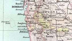
Situated among the eastern slopes of the Western Ghats, the state covered an area of 2,396 square kilometres, and had a population of 137,268 in 1901.[1]
The town of Bhor, once the capital of the princely state, is located about 51 kilometres south of Pune, adjacent to Bhatghar Dam. The royal palace is still present.Also present in the vicinity is the temple of Bhoreshwar, dedicated to Lord Shiva. A temple dedicated to goddesses Janubai and Khiloba is located in Mhalawadi, a village close to the Bhatghar Dam.
History
| Princely state |
|---|
| Individual residencies |
| Agencies |
|
| Lists |
The Jagir (fiefdom), which was the forerunner of the state, was granted to Shankarji Narayan for his services as the Pant Sachiv, one of the eight hereditary Maratha ministers, by Rajaram Chhatrapati in 1697.The jagir remained part of the Maratha empire until the 1818 when Peshwa rule came to an end.The jagir then became part of the shortly lived Satara state with an agreement signed with the British East India Company in 1820.[2] In 1838-39,the state experienced uprising by the Ramoshi against the British.It is believed that personalities associated with the deposed Bajirao II instigated the troubles.[3]
The ruling family of Bhor were Hindus of the Deshastha Brahmin caste.They continued using the Maratha title Pant Sachiv, only later assuming the royal style of Raja, and were entitled, under British rule, to a hereditary 9-gun salute. The Family deity of the rulers was the goddess Bhorai whose temple is located on Sudhagad. The state also controlled other historic forts such as Rajgad, Rohida and Sarasgad.[4]
Raja Shrimant Sir Raghunathrao Shankarrao Babasaheb Pandit Pant Sachiv was the last ruler of the state.During his reign,he implemented many reforms such as abolition of untouchability,freedom of association and introduction of representative government.[5] He signed the accession to the Indian Union on 8 March 1948 which ended the separate existence of Bhor state.[6]
Rulers
Bhor Hindu rulers used the titles of "Pant Sachiv" and "Raja".
Pant Sachivs
- 1697 - death 1707 Shankaraji Narayan Sacheev
- 1707 - death March 1737 Naro Shankaraji
- 1737 - death 1757 Chimnaji I
- 1757 - death 1787 Sadasiv Rao
- 1787 - death 1791 Raghunath Rao
- 1797 - death 1798 Shankr Rao I
- 1798 - death 1827 Pantsachiv Chimnaji Rao II
- 1827 – death 1837 Pantsachiv Raghunath Rao I Chimnaji Rao
- 1837 - death 12 February 1871 Pantsachiv Chimnaji Rao III Raghunath Rao
- 12 February 1871 - death 17 July 1922 Pantsachiv Shankr Rao II Chimnaji Rao (born 1854)
Rajas
- (18 July 1922 -15 August 1947) Raja Shrimant Sir Raghunathrao Shankarrao Pandit Pant Sachiv (titles - Pant Sachiv and Raja)
- With title Pant Sachiv - (18 July 1922 - 3 June 1935) - Pantsachiv Raghunathrao Shankarrao Babasaheb "Baba Sahib" (born 1878)
- With title Raja - (3 June 1935 – 15 August 1947)[7] - Raja Shrimant Sir Raghunathrao Shankarrao Babasaheb Pandit Pantsachiv "Baba Sahib" ; (died 1951), last ruler
The line is nominally continued
- Raja Shrimant Sadashivrao Babasaheb Pandit Pantsachiv (1951-1978)
- Raja Shrimant Chintamanrao Abasaheb Pandit Pantsachiv (1978– ... )
See also
References
- ↑ Bhor Princely State (9 gun salute)
- ↑ Kulkarni, Sumitra (1995). The Satara raj, 1818-1848 : a study in history, administration, and culture (1st ed.). New Delhi: Mittal Publications. pp. 42–43. ISBN 9788170995814. Retrieved 18 December 2016.
- ↑ Desai, S. P. (1970). "A LITTLE KNOWN RISING INSTIGATED BY THE EX-PESHWA (1838-1839)". Proceedings of the Indian History Congress. 32: 63–68. JSTOR 44138506.
- ↑ Milind Gunaji (2010). Offbeat Tracks in Maharashtra. Popular Prakashan. pp. 11–. ISBN 978-81-7991-578-3.
- ↑ Ganesh Vasudeo Tagare (1948). Historical Grammar of Apabhraṁśa. Motilal Banarsidass Publ. ISBN 978-81-208-0290-2.
- ↑ WorldStatesmen - India - Princely States A-J
- ↑ McClenaghan 1996, p. 80.